Julier Pass to Fuorcla Grevasalvas to Maloja 
Distance: 5.2 - 8.4 miles (one way)
near St Moritz in Eastern Switzerland
By: Diane Greer
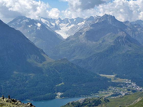
Peaks towering above the southwest side of Maloja
Two pretty lakes, a panoramic pass and lovely views of the Albula and Bernina Alps are the scenic rewards of this hike crossing the rugged range between Julier Pass and the Upper Engadine Lakes plateau.
See Trail Detail/Full Description
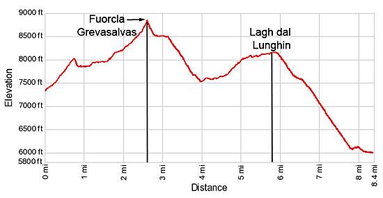
- Distance: 2.6 miles (one way) to Fuorcla Grevasalvas
8.4 miles (one way) to Maloja (Complete Hike) - Elevation: 7,330-ft. at Trailhead
8,819-ft. at Fuorcla Grevasalvas
5,950-ft. at Maloja (Complete Hike) - Elevation Gain: 1,490-ft. to Fuorcla Grevasalvas
-3,542-ft. to Maloja (Complete Hike) - Difficulty: moderate-strenuous
- More Hikes in:
St Moritz / Eastern Switzerland
Why Hike Julier Pass to Fuorcla Grevasalvas to Maloja
This great hike travels up a beautiful valley, crosses the scenic Fuorcla Grevasalvas (Grevasalvas Pass) and then traverses high above the north side of the Upper Engadine valley before dropping down to Maloja. Along the way the hike visits two idyllic lakes and enjoys splendid views of the Albula and Bernina Alps.
The day starts with a postbus ride to a stop just west of Julier Pass. From the bus stop head south on a trail climbing steeply to a hanging valley cradling pretty Lake Grevasalvas beneath the rugged slopes of Piz Lagrev. Beyond the lake the trail travels through lovely meadows, crosses a boulder field and then climbs talus slopes to Fuorcla Grevasalvas. Here panoramic views encompass the peaks of the Albula range, located to the north of the Engadine Lakes plateau, and the Bernina peaks to the south. The glacier-clad slopes of Piz Gluschaint to Piz Fora dominate the views to the south of Lake Sils (Silsersee/Lej da Segl) while the Monte Sissone massif fills the skyline above Maloja to the southwest.
From the pass a rocky trail descends along the south facing slopes of Piz d’Emmat Dadaint and then turns south, dropping steeply to the pretty pastures of the Plaun Grand were it turns west toward Lake Lunghin. A climb through rocky meadows and along talus slopes leads to the hanging valley where Lake Lunghin lies nestled in a rocky bowl.
From the lake a trail descends steeply to Maloja, with grand views of the Bernina Range and the Upper Engadine Lakes. In Maloja, hikers can catch a postbus back to St. Moritz.
Note: This hike travels through several boulder fields and includes a steep descent to Maloja. Alternatively, the hike can be shortened and made easier by dropping down from the pass to Plaun de Lej, for a 6.25 mile hike, or traversing above Lake Sils to Sils/Segl Baselgia, for a 6.9 mile hike.
Elevation Profile
| Support our Site |
Trail Resources
Trail Detail/Full Description / Trail Photo Gallery / Trail Map
Basecamp(s) Information:
St Moritz
Region Information:
Eastern Switzerland
Other Hiking Regions in:
Switzerland