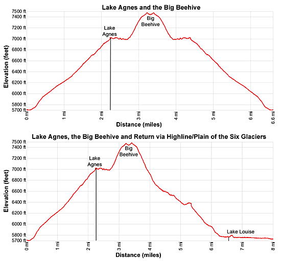
Details: Lake Agnes and the Big Beehive 
Distance: 4.5 - 8.0 miles (round trip)
Banff National Park, near Banff in The Canadian Rockies
By: Diane Greer
Hike Facts
- Distance: 4.5 - 8.0 miles (round trip)
- Elevation: 5,720-ft. - 7,480-ft.
- Elevation Gain: 1,283-ft. - 1,760-ft.
- Difficulty: moderate
- Trail Highlights: See Trail Intro
- Basecamp(s): Banff / Lake Louise
- Region: The Canadian Rockies
This popular hike leads to lovely Lake Agnes set at the foot of a scenic cirque. Extend the hike by climbing to panoramic viewpoints atop the Big and/or Little Beehives. Optional return via the Highline features fabulous views of Mount Victoria and the Victoria Glacier.
To Lake Agnes
Distance from Trailhead: 4.4 miles (round trip)
Ending/Highest Elevation: 7,003-ft.
Elevation Gain: 1,283-ft.
To reach the trailhead for Lake Agnes, walk northwest along the east shore of Lake Louise (5,680-ft.) past the Chateau Lake Louise. The lakeshore offers breathtaking views down the length of the lake to Mount Victoria (11,364-ft.), Mount Collier (10,603-ft.) and Popes Peak (10,370-ft.). On a calm morning the high peaks adorned with glaciers are perfectly reflected in the lake’s turquoise waters.
Follow the broad walkway as it curves to the left (west) along the lake’s northwestern shore. After walking 0.2 miles reach a junction and a trailhead sign. Turn right (northwest) on the trail marked for Lake Agnes Tea House and the Big Beehive.
The broad trails climbs on moderate to moderately steep grades through spruce-fir forest up the northwestern slopes of the Lake Louise Valley. At 1.75 miles reach a trail junction and Mirror Lake, a small pond set beneath the sheer cliffs of the Big Beehive.
Turn right at the junction toward Lake Agnes and the Beehives. Beyond Mirror Lake the trail continues its ascent up a series of switchbacks. Openings in the trees offer glimpses of the high peaks rising to the west.
At 2.0 miles pass a trail branching right (north) that ascends to the Little Beehive (7,250-ft.). The 0.75 mile round-trip detour climbs to an overlook with fine views that extend northwest toward the head of the Bow Valley, southeast to the summits rising above the Banff area and east to Mount Richardson (10,122-ft.) and the high peaks of the Slate Range.
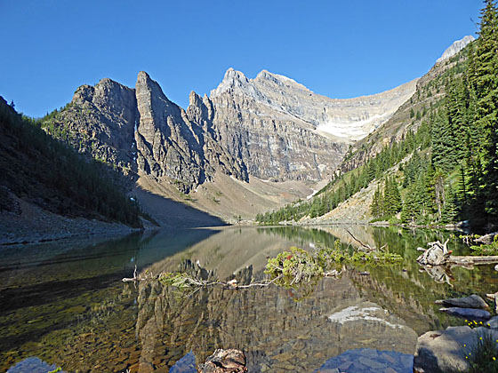
Soon the trail ascends two steep wood staircases that climb over a cliff with a waterfall on Lake Agnes’ outlet stream. At the top of the stairs is a narrow opening where the outlet stream flows out of the basin. Ahead views open to Lake Agnes nestled at the foot of a pretty cirque anchored by Mount Whyte (9,809-ft.) and Mount Nublock (9,703-ft.) to the west. The Devils Thumbs, an interesting rock formation, rises to the east of Mount Whyte.
The popular Lake Agnes Teahouse, at 2.2 miles, offers sublime views of the lake. Unfortunately the place is typically a mob scene. My advice is to walk past the tea house and find a quieter spot along Lake Agnes’ north shore to take a short break.
Returning to Lake Louise from the Teahouse is a 4.4 miles round-trip hike. If time and energy allow, I highly recommend a side trip to the Big Beehive or the Little Beehive.
To the Big Beehive
Distance from Trailhead: 6.5 miles (round trip)
Ending/Highest Elevation: 7,450-ft.
Elevation Gain: 447-ft.
To continue to the Big Beehive and/or the Plain of the Six Glaciers, follow the trail traversing the north shore of the Lake Agnes. At 2.6 miles the trail curves around the head of the lake and then climbs short switchbacks up scree cover slopes to a saddle between the Big Beehive and the Devils Thumb at 3.0 miles.
To visit the Big Beehive (7,450-ft.), turn left at the saddle and follow an undulating trail east along the ridge crest for 0.25 miles to an overlook with a gazebo at the end of the ridge. Here views extend east to Slate Range. Lake Louise lays 1,770-ft. below on the valley floor. Numerous overlooks along the ridge offer views of Mount Victoria, Mount Lefroy, Mount Aberdeen and Haddo Peak towering above the south side of the Lake Louise Valley. Retrace your steps back to the saddle after enjoying the views.
At this point you have a choice of return routes. The shortest option is to return the way you came, via the Lake Agnes Trail. Total round-trip from Lake Louise to the Big Beehive and back is 6.6 miles.
As an alternative, I recommend turning the hike into a loop by returning to Lake Louise via the Highline and Plain of the Six Glaciers trails. This option offers terrific views of Mount Victoria and the Victoria Glacier. Total distance for the loop is 8.0 miles.
To the Little Beehive
The 0.75 mile round-trip detour to the Little Beehive climbs to an overlook on a ridge with fine views extending northwest toward the head of the Bow Valley, southeast to the summits rising above the Banff area and east to Mount Richardson (10,122-ft.) and the high peaks of the Slate Range. A short-cut on the return descends to Lake Agnes near the teahouse.
It is also possible to hike to Lake Agnes and then climb to the Little Beehive. After reaching Lake Agnes, go pass the teahouse and look for a trail to the right (north) that climbs the wooded hillside behind the teahouse. This trail soon joins the main Little Beehive Trail coming up from the Lake Agnes Trail.
Return to Lake Louise via Highline/Plain of Six Glaciers
Distance from Trailhead: 8.0 miles (loop)
Ending/Highest Elevation: 7,480-ft.
Elevation Gain: -1,760-ft.
From the junction on the saddle between the Big Beehive and the Devils Thumb, walk uphill (south) on a trail that climbs through trees to a shoulder on the ridge extending from Mount Whyte at 3.6 miles.
From the ridge the trail descends steep switchback through viewless forest to a junction with the Highline Trail at 4.2 miles. Turn right (west) on the Highline Trail toward the Plain of the Six Glaciers. The trail to the left climbs back to Mirror Lake in 0.6 miles and returns to Lake Louise in 2.4 miles.
The Highline Trail travels through forest for 0.3 miles and then breaks from the trees. In the open meadows great views open to Fairview Mountain (9.000-ft.), Haddo Peak (10,070-ft.), Mount Aberdeen (10,335-ft.) and Mount Lefroy towering above the south side of the valley. Mount Victoria fills the skyline at the head of the valley (to the west). These peaks are part of the massive cirque ringing the Lake Louise valley. Remnants of the glaciers that once filled the valley cling to the peak’s steep slopes and summits. Below the trail the remains of ancient moraines and a glacial outwash plain, the glacial sediments deposited by the retreating glacier, fill the valley floor.
At 5.3 miles reach the junction with the Plain of the Six Glaciers trail coming up from the valley floor. We make a hard left (east/northeast) on the trail heading back down the valley. Straight ahead the trail leads to an overlook below Mount Victoria’s sheer cliffs, adding 3.3 miles and about 950-ft. in elevation gain to the hike. See the Lake Agnes – Plain of the Six Glaciers Loop for more information.
The trail back to Lake Louise descends on moderate grades through meadows and forest along the northwest side of the valley. At 6.3 miles the grade abates as the trail skirts the northwestern side of a delta where the glaciers’ meltwater stream has deposited gravel and other debris as it flows into Lake Louise.
At 6.6 miles the trail curves around the head (southwest end) of Lake Louise. Here great views open down the length of the lake to the Chateau Lake Louise. The remainder of the hike traverses a broad trail along the northwestern shore of Lake Louise. You are now sharing the walk with many tourists strolling along the shore.
At 7.6 miles the trail starts curving to the right (east/southeast) around the foot of the lake, past the Chateau to the trailhead at 8.0 miles.
Elevation Profile
Driving Directions
From Lake Louise Village, AB, Canada The Lake Louise Village is located along the Trans-Canada Highway (AB-1). Take the Bow Valley parkway exit toward Lake Louise to reach the hotels and services area.
Head west on the Bow Valley Parkway which turns into Lake Louis Drive for 2.5 miles and turn left into the Lake Louise Parking area access road. Drive along the road to the reach the lower and upper lot. The walk to the lake is shorter from the lower lot.
During the height of the summer the parking lot near the lake fills early. To reach the lake, park in the Lake Louise Overflow Parking area along the Trans-Canada Highway, located 6 miles south of Lake Louise Village. Regularly scheduled shuttle buses run between the overflow parking are and the lake.
If you are staying in the Lake Louise Village, regularly scheduled shuttle buses run from the Sampson Mall in Lake Louise Village to the lake.
Check the Banff National Park website for the latest information on public transit routes and schedule for more information . ( Link: https://www.banfflakelouise.com/explorethepark/transit-and-shuttles ).
From Field, BC Canada, AB, Canada: Head east on the Trans-Canada Highway (BC-1 E), which turns into AB-1 when it crosses the border into Alberta, for 15.7 miles and then take the Bow Valley exit toward Lake Louise. Turn right onto Lake Louise Drive and follow the road for 2.5 miles. Turn left into the Lake Louise Parking area access road. Drive along the road to the reach the lower and upper lot. The walk to the lake is shorter from the lower lot.
During the height of the summer the parking lot near the lake fills early. If the parking lot is full you will be directed to the Lake Louise Overflow Parking area, location along the Trans-Canada Highway 6 miles south of Lake Louise Village. Regularly scheduled shuttle buses run between the overflow parking are and the lake.
Check the Banff National Park website for the latest information on public transit routes and schedule for more information . ( Link: https://www.banfflakelouise.com/explorethepark/transit-and-shuttles ).
From Banff, AB, Canada: Head southwest on the Trans-Canada Highway (AB-1 W) for 33.9 miles and then take the Bow Valley Parkway exit toward Lake Louise. Turn left onto the Bow Valley Parkway that turns into Lake Louise Drive. Follow this road for 2.5 miles and turn left into the Lake Louise Parking area access road. Drive along the road to the reach the lower and upper lot. The walk to the lake is shorter from the lower lot.
During the height of the summer the parking lot near the lake fills early. When the lot is full, billboards along the Trans-Canada Highway will direct you to the Lake Louise Overflow Parking area, located 6 miles south of Lake Louise Village. Regularly scheduled shuttle buses run between the overflow parking are and the lake.
Check the Banff National Park website for the latest information on public transit routes and schedule for more information . ( Link: https://www.banfflakelouise.com/explorethepark/transit-and-shuttles ).
Trail Resources
Trail Intro / Trail Photo Gallery / Trail Map
Basecamp(s) Information:
Banff / Lake Louise
Region Information:
The Canadian Rockies
Other Hiking Regions in:
Alberta / British Columbia