Details: Sentinel Pass 
Distance: 7.0 miles (round trip)
Banff National Park, near Banff in The Canadian Rockies
By: Diane Greer
Hike Facts
- Distance: 7.0 miles (round trip)
- Elevation: 6,183-ft. - 8,566-ft.
- Elevation Gain: 2,383-ft.
- Difficulty: moderate-strenuous
- Trail Highlights: See Trail Intro
- Basecamp(s): Banff / Lake Louise
- Region: The Canadian Rockies
The trail to Sentinel Pass features exceptional views of the jagged summits of the Valley of the Ten Peaks, set against an ever evolving foreground of larches, meadows and rugged slopes. At the pass the views expand, extending north to stunning Paradise Valley.
Trailhead to Sentinel Pass
Moraine Lake sits at the foot of a huge cirque formed by the summit of the Valley of the Ten Peaks to the south and Wenkchemna Peak (10,407-ft.), Eiffel Peak (10,116-ft.), Pinnacle Mountain (10,060-ft.) and Mount Temple (11,621-ft.) to the west/northwest. The rock pile at the foot of the lake, part of an ancient moraine, is a favorite spot for photographers to snap photos of this gorgeous turquoise lake set against the stunning backdrop of the Ten Peaks.
After enjoy the views, walk south along Moraine Lake’s northwest shore. Near the boat dock you will see a trailhead kiosk. Here you will find the Larch Valley trail, branching right (southwest) toward Sentinel Pass and the Minnestimma Lakes. The Moraine Lakeshore trail, continuing straight ahead, is a 1.8 miles round-trip stroll along the lake’s northwest shore.
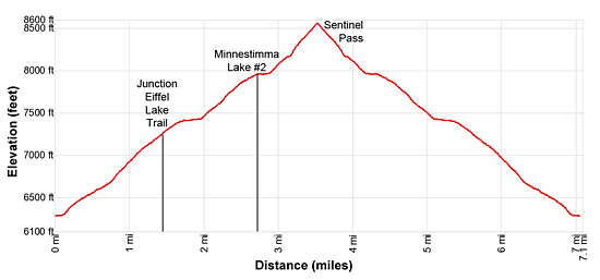
Follow the broad Larch Valley trail as it ascends on moderate grades through spruce-fir forest. After 0.7 miles the trail turns northwest and climbs a series of moderately-steep switchbacks. On the last switchback the grade abates and the trail reaches a “Y” intersection at 1.4 miles. Bear right (northwest) on the Larch Valley trail toward Sentinel Pass. The trail to the left (west) heads toward Eiffel Lake and Wenkchemna Pass.
At 1.7 miles views open as the trail traverses the north side of a long meadow. Here panoramic vistas encompass the ten peaks; Mount Babel (10,171-ft.), Mount Fay (10,607-ft.), Mount Little (10,300-ft.), Mount Bowlen (10,076-ft.), Mount Yonsa (10,017-ft.), Mount Perren (10,007-ft.), Mount Aleen (10,857-ft.), Mount Tuzo (10,656-ft.), Deltaform Mountains (11,230-ft.) and Neptuak Mountain (10,617-ft.). The Fay Glacier extends along the slopes of Mount Fay, Mount Little and Mount Bowen. Eiffel and Pinnacle Mountain rise above the trees to the northwest. Around the meadows larch trees are now mixed in the Englemann Spruce and alpine firs.
At 1.9 miles the trail briefly reenters the trees. Soon the trees give way to the Larch Valley’s lovely meadows sprinkled with wildflowers. Ahead Eiffel Peak and Pinnacle Mountain tower above the west side of the Larch Valley. Mount Temple (11,621-ft.) rises to the east. Sentinel Pass is now visible on the ridge between Mount Temple and Pinnacle Mountain.
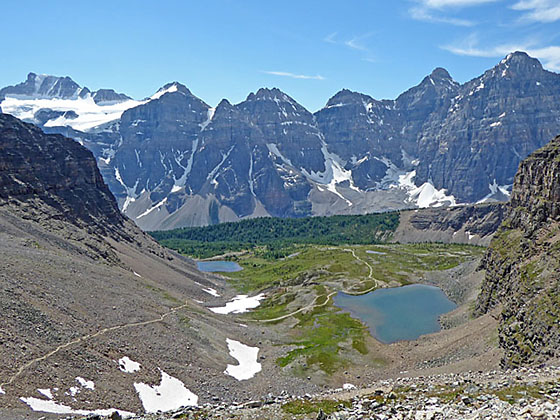
Behind you, to the south, are breathtaking, ever-evolving views of the alpine meadows set against a stunning backdrop of the high peaks. Soon you will see the first of the two Minnestimma Lakes, to the right (east), nestled along the base of Mount Temple.
At 2.7 miles reach south end of the second and largest of the two lakes. The lake, set amid meadows and talus slopes, is the perfect place to take a break. From the lakeshore enjoy fine views of the Sentinel Pass trail climbing through talus slopes to the saddle between Mount Temple and Pinnacle Peak. Behind you are panoramic views of the Valley of the Ten Peaks.
Beyond the last lake the trail climbs steeply up scree covered slopes, gaining over 560-ft. to the pass. A few switchbacks facilitate the climbs near the top of the pass.
As you crest Sentinel Pass (8,566-ft.) at 3.5 miles, terrific views open to Mount Lefroy (11,227-ft.), the Mitre (9,476-ft.), Mount Aberdeen (10,335-ft.) and Haddo Peak (10,070-ft.) in Paradise Valley to the north. In the distance, Collier Peak (10,545-ft.) and Popes Peak (10,372-ft.) in the Lake Louise Valley are seen through the gap to the right (east) of the The Mitre. The view of Paradise Valley is limited due to ridges projecting from Pinnacle Peak and Mount Temple.
The jagged profiles of eight summits in the Valley of the Ten Peaks fill the skyline to the south. Below the pass are the magnificent meadows, small lakes and rugged slopes of the Larch Valley. The sheer cliffs of Pinnacle Peak arc along the southwest side of the pass while the castellated slopes of Mount Temple rise to the northeast.
The pass, gained after climbing almost 2,400-ft. from Moraine Lake, is named after the largest obelisk (rock spire) on the north side of Pinnacle Mountain called the Grand Sentinel. Look down the steep scree valley beneath the north side of the pass to see the Grand Sentinel formation.
When you are done enjoying the views from the windswept pass, retrace your steps back to Moraine Lake.
For hikers looking for a more challenging day, an extremely steep trail descends the steep talus slopes on the north side of the pass to Paradise Valley. The trail/route is only recommended for parties with route finding skills and experiences on very steep scree covered slopes with shifting rock. It is easy to lose the trail as you descend. The route is not recommended when covered with ice and snow. The point-to-point hike requires a second vehicle positioned at the Paradise Valley trailhead. See the Paradise to Moraine Lake via Sentinel Pass for more information.
Elevation Profile
Driving Directions
From Lake Louise Village, AB, Canada to the Moraine Lake Trailhead: The Lake Louise Village is located along the Trans-Canada Highway (AB-1). Take the Bow Valley parkway exit toward Lake Louise to reach the hotels and services area.
To reach the trailhead, head west on the Bow Valley Parkway which turns into Lake Louis Drive for 1.4 miles and turn left onto the Moraine Lake Road. Follow the road for 7.6 miles to the Moraine Lake parking area, located on the end of the road. Note: This is a relatively small parking lot for extremely popular area that fills early in the morning.
From Banff, AB, Canada to the Moraine Lake Trailhead: Head southwest on the Trans-Canada Highway (AB-1 W) for 33.9 miles and then take the Bow Valley Parkway exit toward Lake Louise. Turn left onto the Bow Valley Parkway which turns into Lake Louise Drive for 1.4 miles and then turn left onto the Moraine Lake Road. Follow the road for 7.6 miles to the Moraine Lake parking area, located on the end of the road. Note: This is a relatively small parking lot for extremely popular area that fills early in the morning.
From Field, BC Canada to the Moraine Lake Trailhead: Head east on the Trans-Canada Highway (BC-1 E), which turns into AB-1 when it crosses the border into Alberta, for 15.7 miles and then take the Bow Valley exit toward Lake Louise. Turn right (west) on the Bow Valley Parkway which turns into Lake Louis Drive for 1.4 miles and then turn left onto the Moraine Lake Road. Follow the road for 7.6 miles to the Moraine Lake parking area, located on the end of the road. Note: This is a relatively small parking lot for extremely popular area that fills early in the morning.
Trail Resources
Trail Intro / Trail Photo Gallery / Trail Map
Basecamp(s) Information:
Banff / Lake Louise
Region Information:
The Canadian Rockies
Other Hiking Regions in:
Alberta / British Columbia