Details: Piute Pass 
Distance: 7.0 - 9.6 miles (round trip)
John Muir Wilderness Area, Inyo National Forest, near Bishop in California's Southeastern Sierra
By: Diane Greer
Hike Facts
- Distance: 7.0 - 9.6 miles (round trip)
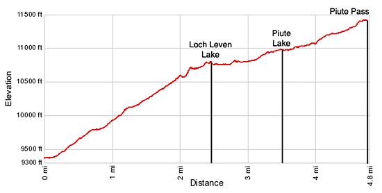
- Elevation: 9,345-ft. - 11,423-ft.
- Elevation Gain: 1,613-ft. - 2,078-ft.
- Difficulty: moderate-strenuous
- Trail Highlights: See Trail Intro
- Basecamp(s): Bishop / Mammoth Lakes
- Region: California's Southeastern Sierra
This great hike to scenic Piute Pass ascends beneath the multi-hued Piute Crags to a beautiful lakes basin tucked beneath Mt. Emerson and Peak 12691. The trail is popular with day hikers and backpackers on multi-day trips to Humphreys Basin, Evolution Valley and beyond.
Trailhead to Piute Lake
Distance from Trailhead: 7.0 miles (round trip)
Ending/Highest Elevation: 10,958-ft.
Elevation Gain: 1,631-ft.
From the trailhead parking area walk 0.6 miles up the North Lake Road to the trailhead bulletin board at the southwest end of the North Lake Campground. There is a single track trail that takes off to the right of the bulletin board. There is also a wide trail to the right of the bathrooms just beyond the bulletin board. The two trails meet just beyond the last walk-in campsite.
I suggest taking the wide trail to the right of the bathrooms. Follow the trail as it curves south. Just beyond the last of the walk-in campsites the trail splits. The trail to the left (south) leads to Lamarck Lakes. Continue straight ahead on the Piute Pass trail, following the trail as heads northwest up the valley. In a short distance pass the boundary of the John Muir Wilderness.
The trail climbs on easy to moderate grades through forest of lodgepole pine and quaking aspens, following the course of the North Fork of Bishop Creek. At 0.75 miles cross to the south side of the creek and at 0.85 miles cross back to the north side. After the spring runoff you should be able to rock hop across the first crossing. A log spanning the creek will keep your feet dry on the second crossing.
Beyond the second crossing the trail ascends on a moderate grades. Openings in the tree provide good views of the jagged granite peaks rising to the south of the trail. To the north, the tops of the orange and brown hued Piute Crags contrast nicely with the greens of the quaking aspen and lodgepole pines.
At 1.1 miles the trail begins a moderate ascending traverse along the valley’s south wall beneath the Piute Crags and Mt. Emerson (13,204-ft.). Paintbrush, columbine and penstemmon flank the trail as you climb higher beneath the rusty cliffs of the Piute Crags. As you ascend, trees give way to open slopes with excellent views of the valley and Peak 12691 rising to the south.
At 1.6 miles a series of well engineered switchbacks climb the headwall of the Loch Leven Lake Basin. Near the top of the wall the trail swings southwest, crossing talus slopes and climbing along granite ledges.
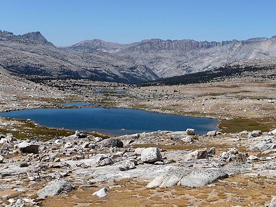
At 2.3 miles the trail reaches the basin, curves to the northwest and shortly arrives at the northeast end of Loch Leven Lake (10,743-ft.). The pretty lake is cradle in a granite basin. The jagged crags of Peak 12691 tower over the lake to the south and the steep granite slopes of Mt. Emerson rise to the north. Looking to the northwest, the saddle on the ridge at the end of the valley is Piute Pass.
The trail now contours along the north shore of the lake through scattered lodgepole pines. Beyond the lake follow the trail as it ascends on gentle to moderate grades through a rocky landscape scatter with trees, passing to the north of a few small lakes.
At 3.1 miles a brief ascent on moderate grades leads to the next bench up the valley. The trail traverses the bench on gentle grades, passing above and to the north of a small lake before arriving at the northeast shore of Piute Lake (10,958-ft.), 3.5 miles from the trailhead. In my opinion the best campsites are located among the trees along the northwestern shore toward the head of the lake. Keep in mind that its gets quite windy at Piute Lake, so pick a sheltered campsite.
To Piute Pass
Distance from Trailhead: 9.6 miles (round trip)
Ending/Highest Elevation: 11,423-ft.
Elevation Gain: 2,078-ft.
To continue to Piute Pass follow the trails as it ascends the valley, climbing granite slopes interspersed with meadows and stunted trees high above the Piute Lake’s northwestern shore. Past the end of the lake the trail continues to climb on moderate grades through a rocky landscape. Below the trail to the south, streams meander through lovely meadows interspersed with small tarns.
Soon you leave the last of the trees behind and ascend through a rocky landscape on moderate grade to Piute Pass (11,423-ft.), 4.8 miles from the trailhead. From the pass panoramic views extend west across Humphrey Basin to the distant peaks rising above the western side of the South Fork of the San Joaquin Valley. To the south is Muriel Peak (12,937-ft.), Mt. Goethe (13,264-ft.) and the summits along Glacier Divide. To the north the distinctively shaped Mt. Humphrey (13,986-ft.) looms over the other peaks. On the eastern side of the pass Mt. Emerson and Peak 12691 tower above the upper end of the North Fork valley. Piute Lake and Loch Leven Lake shimmer on the valley floor, set amid a backdrop of peaks rising to the southeast.
The pass is a good turnaround point for day hikers. Backpackers cross the pass, setting up base camps in lovely Humphreys Basin or descend to Hutchinson Meadow and the John Muir Trail. I use the pass as the first leg of an extended backpack that heads south along the John Muir Trail, climbing to Evolution Valley and then crossing Muir Pass. Exit points to the south of Muir Pass include Bishop Pass, Kearsarge Pass, Mt. Whitney (if you are lucky enough to get a permit) and New Army/Cottonwood Pass. The options are limited only by your vacation time.
Elevation Profile
Driving Directions
From Hwy 395 in Bishop: Turn west on Line Street / Highway 168. Follow Hwy 168 toward Lake Sabrina for 18 miles. Shortly after Aspendell turn right onto the steep, narrow, mostly dirt North Lake Road. Drive 1.6 miles and turn right to park in the hiker parking lot near the Bishop Outfitters pack station. (The sign for the turn is beyond North Lake and somewhat obscured by brush growing along the side of the road.) The parking lot is 0.2 miles up the road.
To reach the trailhead walk back to the North Lake Road and turn right (west). Walk 0.4 miles up the road to the trailhead at the southwest end of the North Lake Campground. Parking in the campground is limited to people registered for campsites.
From Mammoth Lakes: Drive 3.1 miles southeast on Main Street / CA 203 E and turn right onto the entrance ramp for US 395 S. Follow US 395 south for 39.1 miles to Bishop and turn right (west) on Line Street /Highway 168. Follow Hwy 168 toward Lake Sabrina for 18 miles. Shortly after Aspendell turn right onto the steep, narrow, mostly dirt North Lake Road. Drive 1.6 miles and turn right to park in the hiker parking lot near the Bishop Outfitters pack station. (The sign for the turn is beyond North Lake and somewhat obscured by brush growing along the side of the road.) The parking lot is 0.2 miles up the road.
To reach the trailhead walk back to the North Lake Road and turn right (west). Walk 0.4 miles up the road to the trailhead at the southwest end of the North Lake Campground. Parking in the campground is limited to people registered for campsites.
Trail Resources
Trail Intro / Trail Photo Gallery / Trail Map
Basecamp(s) Information:
Bishop / Mammoth Lakes
Region Information:
California's Southeastern Sierra
Other Hiking Regions in:
California