Details: Virginia Lakes 
Distance: 3.2 - 10.0 miles (round trip)
Hoover Wilderness Area, Humboldt-Toiyabe National Forest, near Lee Vining in California's Southeastern Sierra
By: Diane Greer
Hike Facts
- Distance: 3.2 - 10.0 miles (round trip)
- Elevation: 9,800-ft. - 11,120-ft.
- Elevation Gain: 571-ft. - 2,510-ft.
- Difficulty: moderate
- Trail Highlights: See Trail Intro
- Basecamp(s): Lee Vining / Bridgeport
- Region: California's Southeastern Sierra
This great little hike visits five beautiful lakes framed by rugged peaks and then climbs to a scenic pass with panoramic views of the surrounding peaks. Extend the hike with a visit to Summit Lake cradled in a saddle along the Pacific Crest.
Trailhead to the Frog Lakes
Distance from Trailhead: 3.2 miles (round trip)
Ending/Highest Elevation: 10,371-ft.
Elevation Gain: 571-ft.
The Virginia Lakes trail starts from the northwest end of the trailhead parking area (see driving directions). Follow the trail as it travels through scrub covered slopes along the northern shore of Virginia Lake. The multi-hued slopes of Black Mountain (11,797-ft.) tower above the lake to the southwest while massive Dunderberg Peak (12,374-ft.) rises to the north. On nice summer days fishermen bob about the lake in float tubes.
Toward the head of the lake the trail turn north, climbs the hillside above the lake and then veers northwest, ascending on easy grades along a drainage scattered with pines. Pass the boundary for the Hoover Wilderness at 0.3 miles and shortly thereafter reach the eastern shore of Blue Lake (9,886-ft.), tucked in a narrow basin beneath the talus covered slopes of Dunderberg’s southeast ridge.
The trail traverses the talus slopes along Blue Lake’s northern shore and then climbs steeply up the headwall at the western end of the lake. Views from the top of the headwall extend south to the crags and scree-covered slopes of Black Mountain.
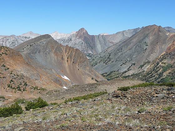
The ascent up the valley continues on moderately steep switchbacks that climb a forested hillside past the ruins of an old mining cabin and then over granite humps to the northeastern shore of pretty Cooney Lake (10,244-ft.) at 1.2 miles. Scattered whitebark pines grow amid the talus slopes and granite ledges rimming the azure blue lake. Scree fields spill down from the avalanche scarred slopes of Black Mountain to the south. The saddle on the distant ridge to the west is Burro Pass (11,110-ft.).
The grade eases as the trail ascends the rocky hillside above the north side of the lake, climbing to the bench harboring a collection of shallow tarns and small lakes known as the Frog Lakes. Right before reaching the first tarn rock hop across Virginia Creek, a gentle stream flowing through a shallow, meadow clad draw at 1.4 miles.
Follow the trail as it wanders through pretty meadows scattered with scrub willows, whiteback pines and granite outcrops along the south side of the first tarn and then curves around the eastern shore of the largest of the Frog Lakes (10,371-ft.) at 1.6 miles. Photogenic granite crags form the backdrop to the north of the lakes. Dunderberg Peak fills the skyline to the northeast. Ahead are views of the peaks and ridges rimming the head of the valley.
To Burro Pass
Distance from Trailhead: 5.6 miles (round trip)
Ending/Highest Elevation: 11,120-ft.
Elevation Gain: 1,320-ft.
Rock hop across the outlet stream and then contour around the lake’s northern shore. About two-thirds of the way around the lake the trail starts climbing toward Burro Pass, following an ascending traverse on moderately steep grades along the north side of the valley. Meadows soon give way to a dry rocky slopes scattered with stunted, windswept whitebark pines. As you ascend enjoy ever improving views of the jagged peaks and crags lining the valley’s southern wall.
At 2.2 miles the path passes above the northern shore of the last of the Frog Lakes. Rugged peaks frame this scenic jewel, set amid a stark landscape at the head of the valley.
Soon we leave the last of the trees behind and climb through a barren, rock strewn landscape toward the saddle on the ridge at the head of the basin. Be sure to take a break from the climb and enjoy the panoramic views of the shimmering blue lakes spread along the valley floor, framed by multi-hued slopes of Dunderberg Peak and the austere rugged gray profile of Black Mountain. A series of switchback facilitate the final stiff climb to Burro Pass (11,120-ft.), located 2.8 miles from the trailhead.
After enjoying the views of Virginia Lakes basin cross to the west side of the pass where a faint use trail leads to a nice lunch spot with wonderful views to the northwest. Summit Lake (10,183-ft.) lies nestled in a saddle below the steep southern flanks of Camiaca Peak (11,739-ft.). Beyond a sea of summits, punctuated by Virginia Peak (12,001-ft.), fill the skyline.
The pass is a good turn around point if you are looking for a short hike and want to spend the afternoon lazing around one of the scenic Virginia Lakes. For hikers with the time and energy I recommend extending the trip to Summit Lake.
To Summit Lake
Distance from Trailhead: 10.0 miles (round trip)
Ending/Highest Elevation: 10,183-ft.
Elevation Gain: 2,510-ft.
To reach Summit Lake follow the trail as it descends on switchbacks down the northeast side of a rocky canyon with mineral tinted walls in shades of brown, orange and gray. As you descend views open to the beautiful Green Creek Basin and the Hoover Lakes. Ahead the colorful slopes of Camiaca Peak frame the skyline.
After dropping over 1,000-ft in 1.7 miles the trail reaches a three-way junction, 4.5 miles from the trailhead. Take the trail to the left (northwest), heading to Summit Lake. The trail branching right (northeast) leads to the Hoover Lakes. The trail climbs through meadows along the lake’s outlet stream, reaching Summit Lake (10,183-ft.) 5.0 miles from the trailhead.
The aptly named Summit Lake is nestled in a saddle along the Pacific Crest. Camiaca Peak (11,739-ft.) rises to the north. The southern shore is flanked by a minor peak on a ridge extending from Excelsior Mountain (12,446-ft) to the south. Past Summit Lake the trail drops into the backcountry of Yosemite National Park.
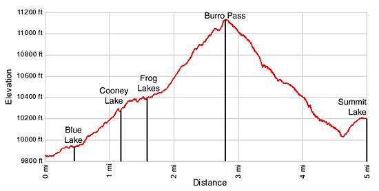
Elevation Profile
Driving Directions
From Lee Vining: Drive 12 miles north on Highway 395 and turn left (west) on the Virginia Creek Road. Follow the road for 6.1 miles to the trailhead parking lot at the end of the road.
From Bridgeport: Drive 13.2 miles south on Highway 395 and turn right (west) on the Virginia Creek Road. Follow the road for 6.1 miles to the trailhead parking lot at the end of the road.
Trail Resources
Trail Intro / Trail Photo Gallery / Trail Map
Basecamp(s) Information:
Lee Vining / Bridgeport
Region Information:
California's Southeastern Sierra
Other Hiking Regions in:
California