Details: Cottonwood Pass & Chicken Spring Lake 
Distance: 7.4 - 9.0 miles (round trip)
Golden Trout Wilderness, Inyo National Forest, near Lone Pine in California's Southeastern Sierra
By: Diane Greer
Hike Facts
- Distance: 7.4 - 9.0 miles (round trip)
- Elevation: 9,940-ft. - 11,242-ft.
- Elevation Gain: 1,200-ft. - 1,302-ft.
- Difficulty: moderate
- Trail Highlights: See Trail Intro
- Basecamp(s): Lone Pine / Bishop
- Region: California's Southeastern Sierra
Fine views of Horseshoe Meadows and the Great Western Divide greet hikers at the top of Cottonwood Pass. Scenic Chicken Spring Lake is less than a mile beyond and makes for a nice day hike or first night destination for backpacking trips into Sequoia-Kings Canyon National Park.
Trailhead to Cottonwood Pass
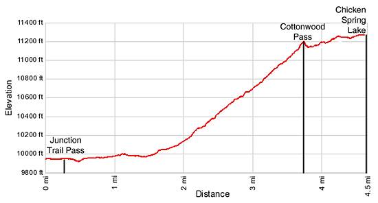
Distance from Trailhead: 7.4 miles (round trip)
Ending/Highest Elevation: 11,140-ft.
Elevation Gain: 1,200-ft.
The broad, sandy trail to Cottonwood Pass heads east, traveling on easy grades through scattered pine trees, skirting the north side of Horseshoe Meadow. In a short distance the trail enters the Golden Trout Wilderness and at 0.3 miles reaches a signed trail junction. The path to Trail Pass branches to the left. To the right is the trail leading to the pack station. Continue straight ahead on the trail to Cottonwood Pass.
Openings along the way provide nice views of Horseshoe Meadow. To the west Trailmaster Peak rises to the north of Cottonwood Pass. After a mile of hiking the trees thicken, restricting the views of the surrounding area.
At the western end of Horseshoe Meadow, 1.4 miles from the trailhead, the path crosses two streams cascading down a pretty draw. Just beyond the streams the trail begins climbing, initially on an easy grade that becomes steeper as the path climbs a series of moderately steep switchbacks to Cottonwood Pass, gaining over 1,170-ft. in 2.3 miles.
As you climb the trees thin and views open to the rocky ridge to the south of Cottonwood Pass. At 2.8 miles the trail ascends around and above a willow choked draw. The open terrain offers nice views of Horseshoe Meadow. To the east are the peaks and ridges lining the upper end of the Cottonwood Creek drainage and, in the distance, the Inyo Mountains rising above the Owens Valley.
Arrive at Cottonwood Pass (11,140-ft.) 3.7 miles from the trailhead. To the east are great views of the scenery you’ve been enjoying on the climb to the pass. After soaking in the views to the east cross to the west side of the pass and take a short detour south for about 0.1 miles for far reaching views of the southern end of the Great Western Divide. Trailmaster Peak rises above the pass to the north.
To Chicken Spring Lake
Distance from Trailhead: 9.0 miles (round trip)
Ending/Highest Elevation: 11,242-ft.
Elevation Gain: 1,302-ft.
To proceed to Chicken Spring Lake continue on the trail over the pass. Just below the west side of the pass is a signed trail junction. The trail straight ahead leads to Big Whitney Meadows. To the left is the southbound Pacific Crest Trail (PCT). Turn right and follow the north bound PCT heading toward Rock Creek.
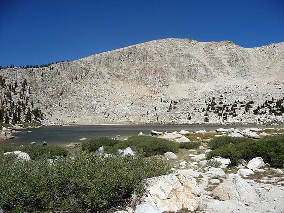
The trail now skirts the north side of a meadow and then climbs a rocky hillside scattered with gnarled foxtail pines. At 4.3 miles reach a junction with the spur trail to Chicken Spring Lake. The junction is located just before the trail crosses the lake’s outlet stream. Turn right (north) on the Chicken Spring Lake trail and follow the trail as it climbs through pretty meadows to the south shore of Chicken Spring Lake (11,242-ft.), 4.5 miles from the trailhead.
Scenic Chicken Spring Lake is nestled in a small cirque. The southern side of the lake is clad in rocky meadows scattered with scrub willows and gnarled foxtail pines. Sheer granite cliffs rise above the northern and eastern shores. Campsites are located to the south of the lake and in the meadows along the outlet stream.
The trail to the lake is popular with day hikers, fishermen and backpackers. Backpackers use the lake as an overnight stop on the way to Rock Creek, Lower Soldier Lake, Mt. Whitney and other destinations in Sequoia National Park.
I recommend that day hikers with the time and energy continue along the northbound PCT for another half mile to a great viewpoint above the western side of the lake. Return to the PCT via the spur trail and turn right (northeast). The trail crosses the outlet stream for Chicken Spring Lake and then climbs steeply up the rocky slope to the west of the lake on long switchback, gaining 300-ft in just over a half mile.
At the top of the hill enjoy great views to the west of Big Whitney Meadows. In the distance are the peaks and ridges lining the southern end of the Great Western Divide. After enjoying the scenic setting retrace your steps to the trailhead.
Elevation Profile
Driving Directions
From Lone Pine: From US Highway 395 in Lone Pine, CA, turn west on Whitney Portal Road. Travel along the road for 3 miles and turn left (south) on Horseshoe Meadow Road. Follow the paved road for 19.6 miles, climbing a series of switchbacks to the end of the road at the Horseshoe Meadows parking area. The Cottonwood Pass trailhead is located at the west end of the parking area.
From Bishop: Drive south on Highway 395 for 57.4 miles to Lone Pine, CA, and turn west on the Whitney Portal Road. Travel along the road for 3 miles and turn left (south) on Horseshoe Meadow Road. Follow the paved road for 19.6 miles, climbing a series of switchbacks to the end of the road at the Horseshoe Meadows parking area. The Cottonwood Pass trailhead is located at the west end of the parking area.
Trail Resources
Trail Intro / Trail Photo Gallery / Trail Map
Basecamp(s) Information:
Lone Pine / Bishop
Region Information:
California's Southeastern Sierra
Other Hiking Regions in:
California