Tamarack Lakes 
Distance: 9.6 miles (round trip)
John Muir Wilderness Area, Inyo National Forest, near Mammoth Lakes in California's Southeastern Sierra
By: Diane Greer
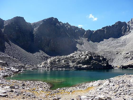
Tamarack Lake
The hike to Tamarack Lakes provides an opportunity to get off the beaten path in the popular Rock Creek drainage. The trail traverses a series of low ridges along the south side of a broad valley before climbing the East Fork of Rock Creek to a stark lakes basin in a rugged cirque.
See Trail Detail/Full Description
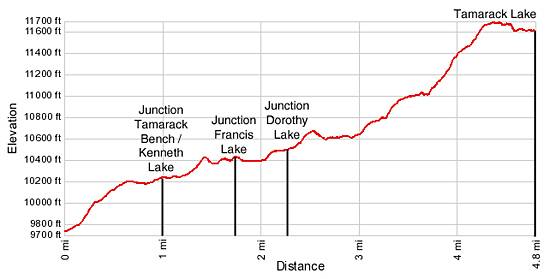
- Distance: 9.6 miles (round trip) to Tamarack Lakes
- Elevation: 9,743-ft. at Trailhead
11,605-ft. at Tamarack Lakes - Elevation Gain: 1,862-ft. to Tamarack Lakes
- Difficulty: moderate-strenuous
- More Hikes in:
Mammoth Lakes / Bishop / California's Southeastern Sierra
Why Hike Tamarack Lakes
Tamarack Lake (11,605-ft.) lies in a stark, barren basin framed by a cirque of serrated granite peaks and craggy ridges anchored by Broken Finger Peak (13,080-ft.). To reach the basin the trail climbs above the eastern shore of Rock Creek Lake, travels up a broad valley with access to a trio of lakes and then steeply ascends the scenic East Fork of Rock Creek valley to a high granite bench situated at the head of the Wheeler Ridge.
While not the most scenic trail in the Rock Creek valley it is certainly is the least traveled, offering a degree of solitude not found along the Little Lakes or Mono Pass trails. So if you are looking to get away from the crowds and get a good workout, lace up your boots and take a hike to the Tamarack Lakes.
Elevation Profile
Trail Resources
Trail Detail/Full Description / Trail Photo Gallery / Trail Map
Basecamp(s) Information:
Mammoth Lakes / Bishop
Region Information:
California's Southeastern Sierra
Other Hiking Regions in:
California