Details: Eagle Lake 
Distance: 6.4 miles (round trip)
Sequoia-Kings Canyon National Park, near Mineral King in California's Southwestern Sierra
By: Diane Greer
Hike Facts
- Distance: 6.4 miles (round trip)
- Elevation: 7,830-ft. - 10,010-ft.
- Elevation Gain: 2,180-ft.
- Difficulty: moderate-strenuous
- Trail Highlights: See Trail Intro
- Basecamp(s): Mineral King
- Region: California's Southwestern Sierra
This short, strenuous hike climbs to a pretty lake nestled in a rugged cirque, with great views of the East Fork Kaweah River valley and the Great Western Divide en route.
Trailhead to Eagle Lake
The Eagle Lake trail starts at the south end of the Eagle / Mosquito parking area. Follow the trail as it heads south, ascending along the west side of the beautiful East Fork Kaweah River valley on easy grades through scrub covered hillsides, sprinkled with scattered fir and junipers. A profusion of willows grow along the river banks and in the marshy areas of the meadows lining the valley floor. Vandever Mountain (11,947-ft.) and Farewell Gap, the saddle to the east of the peak, frame the head of the valley.
Cross a small wood bridge over Spring Creek at 0.3 miles. Tufa Falls, a small waterfall on the creek, is hidden by the thick foliage above the trail. Water flowing in the creek is believed to travel underground along fractured marble bands that surface on the hillside high above the trail.
Beyond the creek the trail continues it steady ascent, passing through scatter stands of firs and junipers. Across the valley Crystal Creek tumbles down a rocky cleft carved in the steep hillside.
Eagle Creek cascades over the trail at 0.9 miles and is easily crossed on rocks. Past the creek the trail steepens and reaches a junction at 1.2 miles. The trail branching to the left leads to White Chief Canyon. Turn right on the Eagle Lake trail and follow the moderately steep trail as it climbs switchbacks traversing the forested hillside toward the Eagle Creek basin. Openings in the trees offer views of Crystal Creek and the peaks rising above the northeast side of the valley.
The grade abates as the trail skirts the edge of a pretty meadow and turns southwest into the forested lower basin. At 1.8 miles reach Eagle Creek where it drops into and is swallowed by a large sink hole.
Past the sink hole the trail crosses to west side of the basin and continues its ascent on easy grades through forest and small meadows. Reach the junction with the trail to Mosquito Lakes trail, which turns right (northeast), at 2.1 mile. Continue straight ahead on the trail signed for Eagle Lake.
At the head of the lower basin the trail veers right (southwest) and ascends steep switchbacks up the rocky hillside leading to the upper basin. A pretty waterfall on Eagle Creek is seen through the trees to the left (east) of the trail. Soon the trees give way to scrub and views open to the boulder covered slopes and rugged ridge lining the western side of the basin. To the east Tulare Peak (11,654-ft.) towers above the Franklin Creek drainage. In the distance are the peaks forming the Great Western Divide.
At 2.6 miles the trail begins a steep ascent through a boulder field. Take occasional breaks from the stiff climb to enjoy the ever improving scenery. To the northeast Empire Mountain (11,550-ft.), Sawtooth Peak (12,343-ft) and Mineral Peak (11,615-ft.) fill skyline. To the east the Great Western Divide rises above the Franklin Creek drainage while ahead the jagged peaks and ridge lining the eastern side of the Eagle Lake basin pop into view.
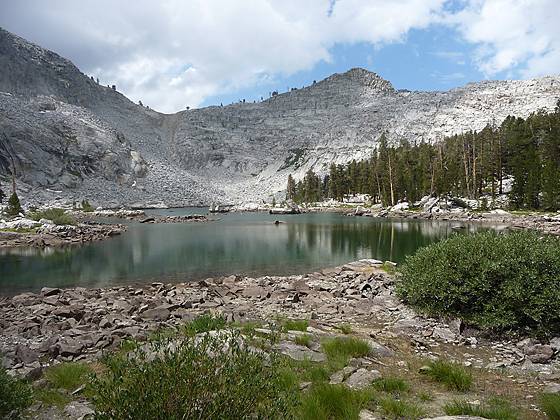
At the top of the boulder field the trail swings south and ascends the granite headwall to the upper basin. In the upper basin the grade abates as the trail travels through a landscape littered with boulders and scattered pine trees. Soon the concrete dam at the end of the Eagle Lake, maintained by Southern California Edison, comes into view and a short distance later the trail arrives at the northern end of Eagle Lake, 3.4 miles from the trailhead.
Eagle Lake (10,010-ft.) is an emerald green jewel tucked in a glacial basin surrounded by rugged granite crags and sheer ridges. Views north from the end of the lake extend to a sea of peaks rising beyond Timber Gap.
The trail continues around the lake’s western shore, where campsites are located amid scatter granite outcroppings and pine trees. A very steep cross-country route to the Mosquito lakes climbs over the ridge to the west of the lake. Another route crosses the gap at the south end of the lake.
Do not expect solitude at the lake. The relatively short distance, scenic beauty of the lake basin and good fishing make it a popular destination for hikers, backpackers and anglers.
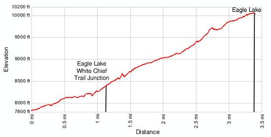
Elevation Profile
Driving Directions
From Visalia: Follow Highway 198 East for 31.5 miles to the Mineral King Road. (There is a small green sign by the side of the road that read “Mineral King 25 miles”.) Turn right onto the Mineral King Road and follow the narrow, winding road for 23.5 miles to the Eagle/Mosquito parking lot at the end of the road.
Trail Resources
Trail Intro / Trail Photo Gallery / Trail Map
Basecamp(s) Information:
Mineral King
Region Information:
California's Southwestern Sierra
Other Hiking Regions in:
California