Details: Avalanche Pass 
Distance: 7.4 miles (round trip)
Maroon Bells-Snowmass Wilderness, White River National Forest, near Aspen in Central Colorado
By: Diane Greer
Hike Facts
- Distance: 7.4 miles (round trip)
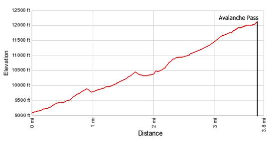
- Elevation: 9,080-ft. - 12,100-ft.
- Elevation Gain: 3,020-ft.
- Difficulty: strenuous
- Trail Highlights: See Trail Intro
- Basecamp(s): Aspen / Marble
- Region: Central Colorado
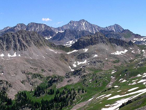
This lightly used trail ascends beautiful Buckskin Basin to a stunning pass with wonderful views of Capitol Peak, Snowmass Mountain and Mount Daly.
Trailhead to Avalanche Pass
From the trailhead the path to Avalanche Pass heads north, ascending along the west side of the North Fork Lost Trail Creek on moderately steep grades through a forest of aspen, spruce and pine trees and intermittent meadows, to a creek crossing at 0.5 miles. Cross the creek. On the east side of the creek the path climbs and then traverses a hillside above the drainage, making a wide arc to the east before dropping down to meet and to cross to the west side of the creek at 1.3 miles. Openings along this section of the trail provide views of Sheep and Treasure Mountains to the south.
Beyond the second crossing the trail follows a low, narrow ridge separating the creek from a small stream. Pretty waterfalls tumble down the hillsides along both sides of the trail. At 1.75 miles the trail arrives at a junction with the Carbonate Creek Trail. Turn left (west) toward Avalanche Pass. Follow the trail for a short distance as it crosses a creek and reaches a second junction in 0.2 miles.
At the second junction turn right (north) toward Avalanche Pass. The trail now climbs a pretty valley on switchbacks and then turns northwest into Buckskin Basin. Buckskin Basin is a real gem. The steep narrow basin is clad in emerald green meadows filled with wildflowers and decorated with rock outcroppings and small copses of stunted evergreens.
Reach an unnamed pass (11,930-ft.) separating the Carbonate Creek Valley and Buckskin Basin at 3.4 miles. Avalanche Pass is now visible on the long ridge to the northeast. Mount Daly (12,610-ft.) rises to the southwest. Be sure to turnaround for views extending southeast to Treasure Mountain.
Slightly beyond the top of the pass is an unmarked trail junction. Turn right at the junction and follow the trail as it ascends through alpine tundra for 0.3 miles to Avalanche Pass (12,100-ft.) at 3.7 miles. (The trail straight ahead descends Carbonate Creek to Marble.)
As you crest the pass a breathtaking panorama unfolds. To the northeast the impressive south face of Capitol Peak (14,130-ft.) towers above the surrounding mountains. Snowmass Mountain (14,092-ft.) and Hagerman Peak (13,841-ft.) rises to the southeast of Capitol Peak. In between are an impressive sea of peaks and ridges. To the south are wonderful views of Mount Daly (12,610-ft) and the peaks and ridges lining Buckskin Basin and Carbonate Creek.
After soaking in the views and taking a lot of pictures return to the trailhead, enjoying great views of Treasure Mountain on the descent. With a car shuttle the hike can be turned into a 9.0 mile semi-loop with the return leg heading down Carbonate Creek to Marble, losing 3,970-ft in 5.3 miles.
Elevation Profile
Buy the BookThis opinionated guide includes all the hikes in the Aspen, Buena Vista, Crested Butte, Marble and Leadville sections of the website plus info on local services and nearby attractions. | |
Driving Directions
From Aspen: From Aspen follow CO-82 West for 28 miles to CO-133. Turn left (south) on CO-133 toward Carbondale and follow the road for 22 miles to County Road 3. Turn left (east) on County Road 3 and drive 2.8 miles to the town of Marble. Drive through the town and continue past Beaver Lake on the now unpaved road to an intersection (2 miles past Marble and 1-mile beyond the lake). If you have a 4WD/high clearance vehicle take the left fork, Road #315 / Lead King Basin Road. (The right fork is Road #314 to Crystal.) Follow this steep, rough road, which stays to the left (north) of Lost Trail Creek, for 0.8 miles to the trailhead. The trailhead is located to the west of a stream crossing.
Passenger cars should find a good place to park off the road in the vicinity of the intersection of Road #315 and at #314 and walk the final 0.8 miles to the trailhead.
From Marble: Drive through the Marble on County Road 3 and continue past Beaver Lake on the now unpaved road to an intersection (2 miles past Marble and 1-mile beyond the lake) If you have a 4WD/high clearance vehicle take the left fork, Road #315 / Lead King Basin Road. (The right fork is Road #314 to Crystal.) Follow this steep, rough road, which stays to the left (north) of Lost Trail Creek, for 0.8 miles to the trailhead. The trailhead is located to the west of a stream crossing.
Passenger cars should find a good place to park off the road in the vicinity of the intersection of Road #315 and at #314 and walk the final 0.8 miles to the trailhead.
Trail Resources
Trail Intro / Trail Photo Gallery / Trail Map
Basecamp(s) Information:
Aspen / Marble
Region Information:
Central Colorado
Other Hiking Regions in:
Colorado