Details: East Snowmass Creek 
Distance: 14.0 - 17.2 miles (round trip)
Maroon Bells-Snowmass, White River, near Aspen in Central Colorado
By: Diane Greer
Hike Facts
- Distance: 14.0 - 17.2 miles (round trip)
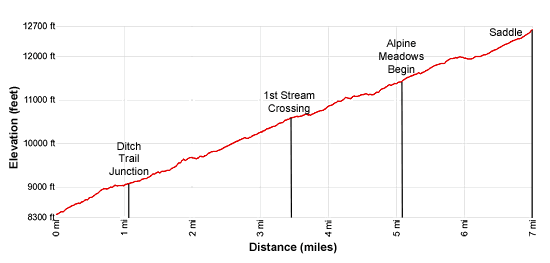
- Elevation: 8,368-ft. - 12,686-ft.
- Elevation Gain: 4,318-ft.
- Difficulty: strenuous
- Trail Highlights: See Trail Intro
- Basecamp(s): Aspen
- Region: Central Colorado
A long sustained climb gaining over 4,300-ft. in 7.0 miles leads to a scenic pass with fine views of the Willow Lake Basin and beyond. The upper section of the trail passes through huge meadows rimmed by red-cliffs and multi-hued peaks.
East Snowmass Pass
The East Snowmass Creek trail initially ascends steep to moderately steep switchbacks through mixed conifers and copses of aspen. Along the way pass a viewpoint overlooking a waterfall on East Snowmass Creek. At 0.6 miles the switchbacks end and the grade moderates a bit.
At 0.7 miles the trail passes into the Maroon Bells-Snowmass Wilderness and heads south, climbing along the west side of the valley. East Snowmass Creek tumbles unseen down the valley floor below the trail.
At 1.1 miles pass the Snowmass Ditch Trail, branching to the left (east). We continue the steady ascent up the valley through evergreens with some nice stands of Aspen.
A short steep climb up a few switchbacks at 1.7 miles leads to a short, almost level section at 1.0 mile. The respite is short lived. Soon the trail again ascends on moderate to moderately-steep grades with a few short, steep segments.
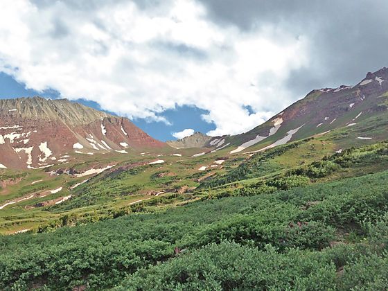
At 2.25 miles the trees give way to meadows interspersed with small clusters of trees. The open terrain offers nice views of the red cliffs rising along the east side of the valley. The hillsides to the west are clad in groves of aspen and evergreens. Thickets of willows thrive along the creek.
At 3.5 miles the trail crosses a creek and enters a spruce-fir forest. Here the ascent briefly moderates only to steepen again at 3.7 miles as the trail crosses a second stream. Small meadows and openings in the trees offer tantalizing glimpses of the red-hued cliffs to the east.
At 4.2 miles the grade moderates. A short distance beyond the trail breaks from the trees and crosses the broad base of an avalanche chute. Here fine views open to the cirque of unnamed 13,000-ft. peaks ringing the head of the valley. Willoughby Mountain (13,142-ft.) rises to the west. The rugged red cliffs lining the east side of the valley tower overhead.
At 4.6 miles the trail starts ascending steeply through scattered trees. The path now curves to the southwest as it climbs away from the creek and up the valley’s western wall. Soon the grade moderates and the trees thin, giving way to beautiful alpine meadows at 5.1 miles.
This area is a great place to stop if you don’t have the time or energy to make it to the pass. The views are lovely and you are likely to have the valley to yourself.
Otherwise, follow the trail as it ascends on moderate grades through rolling alpine meadows sprinkled with thickets of willows and a few clusters of stunted trees. Red and gray hued peaks tower above the head of the valley. The meadows are sprinkled with lovely wildflowers in season.
At 5.8 miles the grade becomes easy as the trail swings to the southeast toward the center of the valley. After crossing a creek at 6.3 miles the trail turns to the south and starts the final moderately-steep to steep climb to the pass, aided by a few switchbacks.
Reach the pass (12,686-ft.), a notch on the ridge, at 7.0 miles. Below you Willow Lake (11,795-ft.) lies nestled in emerald green meadows flanked by the Sievers Mountain to the east and Buckskin Point (13,370-ft.) to the west. Pyramid Peak (14,018-ft.) and the summits rising above the East Maroon Creek valley dominate the view to the south. On a clear day you should be able to pick out the top of Castle Peak (14,265-ft.) rising in the distance to the south. Behind you are fine views down the length of the East Snowmass Creek valley.
On the south side of the pass the trail drops down to a junction with the Willow Lake Trail in 1.0 mile. At the junction turn left to reach Willow Lake in 0.6 miles. Total elevation loss from the saddle to the lake is 880-ft. Alternatively turn right at the junction and climb Willow Pass and then follow the reverse the directions for the Willow Pass hike to reach the Maroon Lake trailhead.
The East Snowmass pass is the turnaround point for most day hikers. Parties with a prearranged car shuttle can continue over the pass to the Maroon Lake trailhead. Backpackers will find nice campsites around the stunted trees in the Willow Lake Basin. A popular 2-3 day backpack climbs the Maroon-Snowmass trail up Snowmass Creek, crosses Buckskin Pass, Willow Pass and East Snowmass Pass and then drops down the East Snowmass trail to the road. Complete the loop with a 0.2 miles walk along the road back to the Maroon-Snowmass trailhead.
Prior to starting out on a backpack, be sure to read the Maroon Bells-Snowmass Wilderness Regulation section found at the bottom of the Four Pass Loop Trail description. Also, check the White River Forest website Wilderness Regulations page for current regulations to insure that there are not any temporary closures or other restrictions not listed on this website.
Elevation Profile
Buy the BookThis opinionated guide includes all the hikes in the Aspen, Buena Vista, Crested Butte, Marble and Leadville sections of the website plus info on local services and nearby attractions. | |
Driving Directions
From Aspen:
Option 1 (Rough, steep and narrow road for part of the drive – 4WD recommended): Drive 6 miles west of Aspen on Highway 82 and turn left on the Brush Creek Road (the main road to Snowmass Village). Continue on Brush Creek Road for 5.5 miles through Snowmass Village and then turn right on Divide Road. Divide Road turns into a gravel road and passes the Krabloonik Restaurant and Kennels. The rough road descends steeply to the bottom of the Snowmass Creek valley where it forks. Take the left fork. The East Snowmass trailhead is just beyond the wooden bridge on the left side of the road. (Continue another 0.2 miles to the Maroon-Snowmass Trailhead, which is also the starting point for the West Snowmass Trail, at the end of the road.)
Option 2 (Better option for 2WD vehicles): Drive 14 miles west of Aspen on Highway 82 to Old Snowmass and turn left on the Capitol Creek/Snowmass Creek Road (next to the Conoco Gas station on the south side of the highway). Continue 2 miles to a "T" intersection. Turn left and follow Snowmass Creek Road (CO Rd. 11) for 5.8 miles to a fork in the road. Take the left fork, staying on Snowmass Creek Road (CO Rd. 11) for 3.4 miles to a “T” intersection. Take a right. The East Snowmass trailhead is just beyond the wooden bridge on the left side of the road. (Continue another 0.2 miles to the Maroon-Snowmass Trailhead, which is also the starting point for the West Snowmass Trail, at the end of the road.)
Trail Resources
Trail Intro / Trail Photo Gallery / Trail Map
Basecamp(s) Information:
Aspen
Region Information:
Central Colorado
Other Hiking Regions in:
Colorado