Details: Lost Man 
Distance: 4.6 - 8.8 miles (one way)
Hunter-Fryingpan Wilderness, White River National Forest, near Aspen in Central Colorado
By: Diane Greer
Hike Facts
- Distance: 4.6 - 8.8 miles (one way)
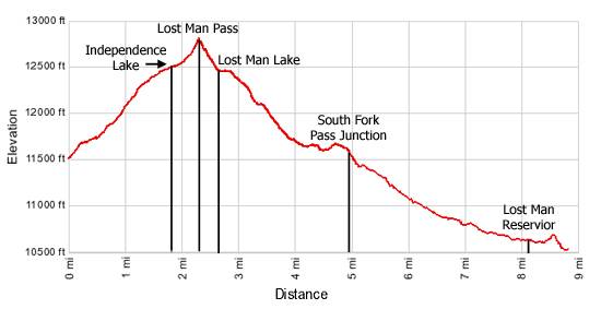
- Elevation: 11,520-ft. - 12,810-ft.
- Elevation Gain: 1,290-ft.
- Difficulty: moderate
- Trail Highlights: See Trail Intro
- Basecamp(s): Aspen
- Region: Central Colorado
This hike traverses two scenic valleys with pretty lakes separated by a panoramic pass. From the pass wonderful views extend to the peaks and ridges along Continental Divide, the Hunter-Fryingpan Wilderness and the Collegiate Peaks Wilderness.
Trailhead to Lost Man Pass
Distance from Trailhead: 4.6 miles (round trip)
Ending/Highest Elevation: 12,810-ft.
Elevation Gain: 1,290-ft.
The Linkins Lake/Upper Lost Man trailhead starts just below timberline to the west of where the Roaring Fork River, really just a creek at this point, drops through a culvert channeling the river beneath Highway 82 near Independence Pass (12,095-ft.). (See driving directions.)
Follow the trail as it ascends on moderate grades through scrub willows up the left (west) side of the Roaring Fork, passing the last few pockets of spruce trees along the way. In less than 0.2 miles come to the junction with the Linkins Lake trail heading left (northwest). Stay right. Just beyond the junction enter the Hunter-Fryingpan Wilderness.
At 0.5 miles cross to the east side of the river on a log bridge. Soon you leave the last of the willows behind as the trail continues its steady ascent through emerald green meadows sprinkled with wildflowers. Geissler Mountain rise above the basin to the northwest while Twining Peak dominates the ridge to the east.
As you climb be sure to turn around and enjoy ever improving views of Independence Mountain (12,703-ft.) and a sea of jagged ridges and summits in the Collegiate Peaks Wilderness to the south.
After walking just over a mile the grade steepens as the trail curves east away from the Roaring Fork and climbs to a bench to circumvent boggy meadows around the river. Once on the bench the trail again heads north, crossing rivulets fed by snowfields from the slopes to the east.
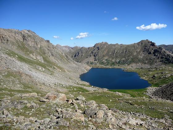
Just before arriving at the southwest end of Independence Lake the trail crosses the lake’s outlet stream. Reach the lake, nestled amid wildflower-filled meadows at the base of 13,000-ft peaks at 1.75 miles. The trail now climbs through meadows along the left (west) side of the lake and heads towards Lost Man Pass, the obvious saddle on the ridge to the north.
Beyond the lake ascend rock strewn meadows on a moderately steep trail to the top of the pass (12,815-ft.) at 2.3 miles. Lost Man is a good example of why hiking to pass is so enjoyable. As you crest the ridge the view to the north unfolds all at once. Lost Man Lake lies cradled in a rocky bowl edged with talus slopes and meadows. Panoramic views extend north to the craggy peaks and ridges of the Continental Divide and Hunter-Fryingpan Wilderness.
To the south, the emerald green expanse of the Roaring Fork drainage is rimmed by the Geissler Mountain and Twining Peak. Across the highway views extend south to a sea of summits in the Collegiate Peaks Wilderness.
Lost Man Pass to Junction with South Fork Pass
Distance from Trailhead: 9.8 miles (round trip)
Ending/Highest Elevation: 11,610-ft.
Elevation Gain: -1,200-ft.
If you are looking for a shorter hike Lost Man Pass is a good turnaround point. Otherwise to complete the semi-loop or do a longer out-and-back day hike, descend the north side of the pass on steep switchbacks through a boulder field to the head of Lost Man Lake, losing 330-ft. in 0.3 miles. At the base of the pass follow the trail as it traverses the right (east) side of the lake through rocky meadows dotted with wildflowers.
At the foot of the lake the path starts its descent of the Lost Man drainage, making a wide arc to the north and then west through a large meadow with scenic views of the Williams Mountains rising to the west. The trail briefly crosses to the west side of Lost Man Creek as it drops through a boggy area filled with wildflowers and small pockets of scrub willows.
As you lose elevation the scrub growth thickens. Soon the trail crosses back to the west side of the creek and plots a course slightly above the valley floor, skirting the marshy areas along the creek. Trees start to appear on the southwest side of the valley as you drop below the timberline.
At 4.6 miles the trail ascends a small knoll and reaches the junction with the South Fork Pass trail at 4.9 miles. If you have the time and energy a side trip to the pass, gaining 140-ft. in 0.3 miles, is a pleasant diversion. Be forewarned that the views, while nice, are hardly panoramic. The junction is a good point to turn around if you are doing a long out-and-back hike from the upper trailhead.
South Fork Junction to Lower Lost Man Trailhead
Distance from Trailhead: 8.8 miles (one way)
Ending/Highest Elevation: 10,540-ft.
Elevation Gain: -2,270-ft.
From the South Fork junction the path follows the arc of the valley as it curves to the south, descending along the west side of the creek. Along the way the path travels through meadows and then scrub growth, skirting the edge of spruce-fir forest growing on the slopes above trail. At 7.5 miles the trail enters a large meadow with nice views down valley.
Reach the head of Lost Man Reservoir at 8.2 miles. The path now wanders along the lake’s western shore to a junction with an old jeep road heading left (east) at the foot of the lake. To reach the lower Lost Man trailhead stay right. The path climbs about 70-feet up a hillside to meet the Midway Pass trail, which switchbacks steeply up the hillside to the right (northwest). Bear left, following the trail as it drops to a wooden bridge crossing the creek. The parking area by Highway 82 is located a short distance beyond the bridge.
Please note that walking along the highway to return to your car at the upper trailhead parking area is NOT recommended. Highway 82 is a very narrow road with little or no shoulder.
Optional Side Trip to Linkins Lake
Distance from Trailhead: 1.2 miles (round trip)
Ending/Highest Elevation: 12,008-ft.
Elevation Gain: 488-ft.
From the Linkins Lake / Upper Lost Man trailhead, follow the trail for 0.2 miles to a signed junction and turn left (northwest) toward Linkins Lake. (The trail to the right leads to Independence Lake and Lost Man Pass.) Follow the trail as it ascends steeply up the hillside to the glacial cirque holding Linkins Lake (12,008-ft.) at 0.6 miles. From the lake enjoy magnificent views of the high alpine meadows and summits surrounding the Continental Divide.
Elevation Profile
Buy the BookThis opinionated guide includes all the hikes in the Aspen, Buena Vista, Crested Butte, Marble and Leadville sections of the website plus info on local services and nearby attractions. | |
Driving Directions
Driving Directions from Aspen:
There are 2 ways to access the Lost Man Trail:
1) Linkins Lake / Upper Lost Man trailhead: Drive 18.5 miles east of Aspen on Highway 82 to the parking lot on the left (north) side of the road at the last switchback before Independence Pass. The trailhead is just to the left of where the Roaring Fork River drops through a culvert channeling the river beneath Highway 82.
2) Lower Lost Man / Midway Pass trailhead: Drive 14 miles east of Aspen on Highway 82 to a large trailhead parking lot on the left (north) side of the road, directly across from Lost Man Campground.
Trail Resources
Trail Intro / Trail Photo Gallery / Trail Map
Basecamp(s) Information:
Aspen
Region Information:
Central Colorado
Other Hiking Regions in:
Colorado