Details: New York Creek 
Distance: 8.2 miles (round trip)
Collegiate Peaks Wilderness, White River National Forest, near Aspen in Central Colorado
By: Diane Greer
Hike Facts
- Distance: 8.2 miles (round trip)
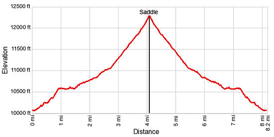
- Elevation: 10,070-ft. - 12,290-ft.
- Elevation Gain: 2,220-ft.
- Difficulty: moderate-strenuous
- Trail Highlights: See Trail Intro
- Basecamp(s): Aspen
- Region: Central Colorado
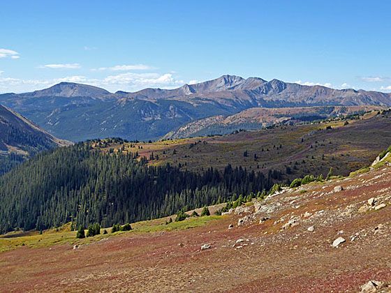
This nice hike climbs to a 12,290-ft. saddle on the divide separating the Bowman Creek and New York Creek valleys. At the divide enjoy great views of American Flag and Italian Mountains and nearby peaks in the Collegiate Peaks and Hunter-Fryingpan Wilderness areas.
Trailhead to Saddle on the Ridge between Bowman and New York Creek Valleys
From the New York Creek parking area (see driving directions) the trail heads south and crosses Lincoln Creek. Depending on the time of year the wide crossing can be knee or ankle deep. Use care when crossing the river early in the season.
Beyond the crossing a boot beaten path traverses gravel flats with scattered willows to a second crossing of a smaller tributary stream. On the other side of the stream the trail passes between tall willows and then curves to the southwest as it ascends gradually along an old jeep road through spruce-fir forest and then scrubby meadows. From the meadows enjoy views of Peak 12450 rising to the west.
At 0.25 miles the trail plunges back into the trees. Soon the grade steepens as the trail climbs a few switchbacks. At 0.75 miles the trail starts ascending through a second meadow on steep switchbacks. As you climb, enjoy every improving views of Peak 12450 to the west and Green Mountain (12,791-ft.) to north.
Reach a junction with the aqueduct access road, an ugly scar in the valley, at 1.0 mile. The aqueduct system diverts water from the New York and Brooklyn Creek drainages to the Grizzly Reservoir. From the reservoir a tunnel carries the water under the Continental Divide to the Twin Lakes Reservoir.
At the junction a trail sign points right (southwest). Make note of this intersection so you do not miss the turn on the return trip to the trailhead.
Turn right and follow the level aqueduct road for 0.5 miles. At 1.3 miles the road reaches the cement intake tunnel for the Brooklyn Gulch Creek Diversion. Here the road curves to the right and then left before continuing its southwest traverse. Soon the cement intake tunnel for the New York Creek Diversion and the end of the road come into view.
Beyond the intake watch for a trail branching left off the road and entering the forest at 1.5 miles. A small sign off the road marks the turnoff, which is easy to miss. If you miss the turn and reach the end of the road, turn around and walk about 50 yards back on the road until you see the trail on the right.
The trail now ascends through forest on easy grades along the east side of the valley, paralleling New York Creek to the right (west). Pass the sign marking the boundary for the Collegiate Peak Wilderness along the way.
At 2.2 miles the trail curves to the right (west), crosses to the west side of New York Creek and then ascends through meadows scattered with willow thickets. Here we get the first views of the peaks rimming the head of the valley.
Soon the trail curves left (southwest) and climbs along the west side of the valley on moderate grades though forest and meadows cleared by avalanches spilling down the steep slopes between Difficult Peak (12934-ft.) and New York Peak (12,811-ft.). A few small streams trickle down the hillside.
From the meadows enjoy nice views of Green Mountain to the north/northeast. As the trail gains elevation the rugged peaks rising along the east side of the valley join the scene.
At 2.7 miles the grade steepens as the trail climbs through a pretty meadow and then reenters the forest. The trail crosses a creek at 3.25 miles and a short distance beyond turns sharply left (south), continuing the stiff ascent through scattered trees.
Soon the trees gives way to meadows as the trail reaches the timberline. From this vantage point the Williams Mountains in the Hunter Fryingpan Wilderness form a nice backdrop for Green Mountain to the northeast. Difficult Peaks towers above the east side of the New York Creek Valley.
For the last half mile the trail, marked by rock cairns and wooden posts, climbs steeply through alpine tundra to a 12,290-ft. saddle on the ridge separating the New York Creek and Bowman Creek valleys. As you climb views open to the high peaks lining the east side of Brooklyn Gulch, the valley to the east of New York Creek.
From the divide views extend north to Difficult Peak. Green Mountain, the Williams Mountains and a sea of peaks in the Collegiate Peaks Wilderness fill the skyline to the northeast. American Flag Mountain (12,713-ft.) and Italian Mountain (13,378-ft.) in the Taylor River Valley dominate the view to the south. Grizzly Peak (13,988-ft.) rises above the unnamed summits to the west.
Hikers looking for a longer walk may want to climb along the ridge to the west of the saddle to the top of Peak 12613 for more great views. Another option, only recommended for experienced off-trail warriors, is to follow a seldom used route to Ptarmigan Lake on the south side of the divide at the head of the Tellurium Valley. From the lake the route climbs over the divide and then descends Brooklyn Gulch to the aqueduct road. This option requires good route finding skills. The descent of Brooklyn Gulch is steep with plenty of downed trees and other obstacles. A map marking the old route and a compass are essential.
My recommendation is to take in the views at the New York Creek saddle and then retrace your steps to the trailhead.
Elevation Profile
Buy the BookThis opinionated guide includes all the hikes in the Aspen, Buena Vista, Crested Butte, Marble and Leadville sections of the website plus info on local services and nearby attractions. | |
Driving Directions
Driving Directions from Aspen: Drive 10 miles east of Aspen on Highway 82 and turn right on the Lincoln Creek Road. Drive 3.2 miles on Lincoln Creek Road to the New York Creek Trail turnoff on the right. Follow the short access road to the trailhead parking area.
Although a 4WD vehicle is not always necessary, high clearance is a must on the Lincoln Creek Road. Check with the White River Ranger Station in Aspen about current road conditions.
Trail Resources
Trail Intro / Trail Photo Gallery / Trail Map
Basecamp(s) Information:
Aspen
Region Information:
Central Colorado
Other Hiking Regions in:
Colorado