Details: Missouri Gulch / Elkhead Pass 
Distance: 9.0 miles (round trip)
Collegiate Peaks Wilderness, San Isabel National Forest, near Buena Vista in Central Colorado
By: Diane Greer
Hike Facts
- Distance: 9.0 miles (round trip)
- Elevation: 9,660-ft. - 13,220-ft.
- Elevation Gain: 3,560-ft.
- Difficulty: strenuous
- Trail Highlights: See Trail Intro
- Basecamp(s): Buena Vista / Leadville
- Region: Central Colorado
The strenuous hike to Elkhead Pass, one of the highest passes in Colorado, steeply ascends scenic Missouri Gulch to a 13,220-ft. pass with panoramic views of the 13,000-ft and 14,000-ft. peaks looming above the expansive meadows of Missouri Basin.
Trailhead to Elkhead Pass
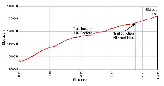
The Missouri Gulch-Elkhead Pass trail is located at the western end of the large trailhead parking area (see driving directions). Follow the path as it descends to and crosses Clear Creek on a good bridge. On the other side of the creek steep switchbacks ascend the south side of the valley through aspen, pine and spruce-fir forest to the foot of Missouri Gulch, gaining 670-ft. in 0.7 miles.
Once in the gulch the steep ascent continues along the west side of Missouri creek for 0.5 miles to a crossing at 1.2 miles. Cross the creek and climb steeply up switchbacks on the east side of the gulch. Soon the trail enters a section of dense timber. Right before exiting the trees pass the remains of an old log cabin at 1.5 miles.
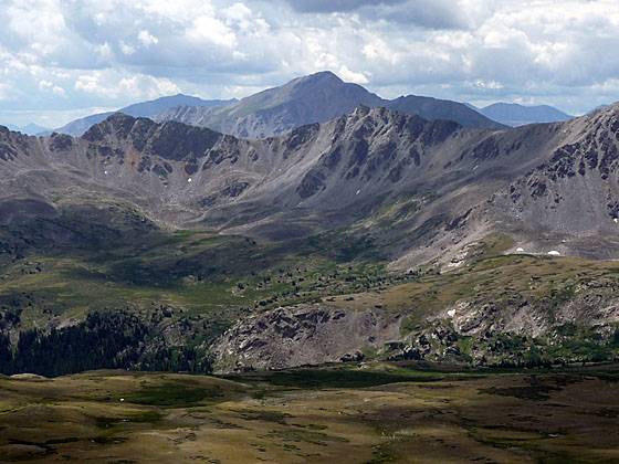
The trail emerges from the trees into a pretty basin decorated with rocky meadows scattered with copses of trees and small thickets of scrub willows. Ahead Mount Belford (14,197-ft.), rising to the southeast, dominates the scene while a granite ridge extending from Missouri Mountain forms the gulch’s western wall.
Follow the trail as it stays to the east of the creek and ascends the beautiful basin on moderately steep grades. Reach the junction with the trail leading to Mount Belford at the 2.1 miles. Here the Belford trail heads left (southeast). Our trail curves southwest and continues climbing the basin.
Cross to the west side of the creek shortly after the junction and follow the trail as it curves to the southeast and then climbs steeply up a small rise. Atop the rise the grade abates a bit as the path curves southwest through meadows and scrub willows. Along the way enjoy wonderful views of the basin’s western wall.
At 2.9 miles the path crosses back to the east side of the creek through scrub willows and steeply ascends another small rise. The trail now traverses on moderately steep grades a rolling landscape clad in tundra, crossing back to the west side of the creek at 3.4 miles. As you climb be sure to turn around for nice views down the gulch to the peaks rising above the north side of the Clear Creek Valley. Ahead, Missouri Mountain (14,067-ft.) towers above the basin.
Reach the junction with a trail heading right (west) to Missouri Mountain at 3.7 miles. Our trail curves left (southeast), climbing a steep, rocky hillside beneath the south face of Mount Belford with the aid of a few switchbacks.
At the top of the hill the grade abates a bit as the trail ascends rocky meadows sprinkled with wildflowers and then swings south for the final stiff climb to Elkhead Pass, reached after gaining 3,560-ft. in 4.5 miles.
The broad pass, located at a low point on the ridge between Missouri Mountain and Mt. Belford, enjoys stunning views to the south of the huge granite cirque towering above the emerald green meadows of Missouri Basin. To the southeast, Mt. Harvard (14,414-ft.) anchors a jagged ridge of 13,000-ft. peaks running west to an unnamed 13,694-ft. summit rising above Silver King Lake. From the unnamed summit the ridge heads north to Emerald Peak (13,904-ft.), Iowa Peak (13,831-ft.) and Missouri Mountain and then turns northeast to Mt. Belford. Mt. Yale (14,194-ft.) rises to the south beyond the cirque. To the north vistas extend to Mount Hope (13,933-ft.), Quail Mountain and, in the distance, Mt. Elbert (14,433-ft.).
From the pass the Missouri Gulch trail descends to the wildflower-filled meadows of Missouri Basin and then switchbacks down to Pine Creek to meet the Pine Creek Trail in 3.3 miles, losing 1,670-ft. along the way.
A trail also leads east from the pass to the top of Mt. Belford. This steep climb gains 977-ft. in 1.1 miles. Hikers reaching the top of Belford along this trail typically descend the Mt. Belford trail to Missouri Gulch and back to the trailhead, a total distance of 9.6 miles.
Elevation Profile
Buy the BookThis opinionated guide includes all the hikes in the Aspen, Buena Vista, Crested Butte, Marble and Leadville sections of the website plus info on local services and nearby attractions. | |
Driving Directions
Driving Direction from Leadville: Travel south on U.S. Hwy 24 for 19.5 miles to County Road 390 / Clear Creek Reservoir Road. Turn right (west) and follow the gravel road, which turns into Forest Road 120, for 8 miles to the Missouri Gulch Trailhead, located on the left (south) side of the road.
Driving Direction from Buena Vista: Travel north on U.S. Hwy 24 for 15 miles to County Road 390 / Clear Creek Reservoir Road. Turn left (west) and follow the gravel road, which turns into Forest Road 120, for 8 miles to the Missouri Gulch Trailhead, located on the left (south) side of the road.
Trail Resources
Trail Intro / Trail Photo Gallery / Trail Map
Basecamp(s) Information:
Buena Vista / Leadville
Region Information:
Central Colorado
Other Hiking Regions in:
Colorado