Details: Devils Lake 
Distance: 14.0 miles (round trip)
Powderhorn Wilderness, Gunnison BLM and Gunnison National Forest, near Lake City in Southwest Colorado
By: Diane Greer
Hike Facts
- Distance: 14.0 miles (round trip)
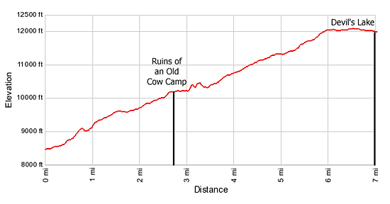
- Elevation: 8,480-ft. - 12,000-ft.
- Elevation Gain: 3,520-ft.
- Difficulty: strenuous
- Trail Highlights: See Trail Intro
- Basecamp(s): Lake City
- Region: Southwest Colorado
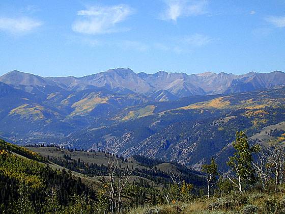
Picturesque groves of mature aspen and beautiful views of the Lake Fork Valley and Uncompahgre Peak are a few of the visual delights on this scenic trail following the Devil's Creek drainage to Devil's Lake, lying beneath the western flanks of the Calf Creek Plateau.
Trailhead to Devil's Lake
From the trailhead parking area (see driving directions below) the trail heads east, climbing an old road to the north of the Devil’s Creek drainage. Soon the trail leaves the road, climbing switchbacks up the west side of the Lake Fork Gunnison Valley. Along the way the path crosses and/or uses sections of the road. In a little over a mile the trail tops a mesa and then gently ascends across the sage brush clad mesa. At 1.5 miles the path turns northeast through a fence line and into the Powderhorn Wilderness. From the mesa nice views extend west to the peaks of the Uncompahgre Wilderness.
Over the next mile the trail again departs from and returns to the old road several times, traversing through pretty stands of aspen and spruce-fir forest. After walking 2.7 miles and gaining over 1,700-ft. the trail passes an old cow camp containing two wood structures.
At the end of the road the trail curves to the southeast and travels along the base of a ridge through forest and meadows above the north side of Devil's Creek. Near the head of the drainage the path makes a wide arc to the northeast to avoid the talus clad slopes of the north facing escarpment of the Cannibal Plateau.
At 4.5 miles the trail briefly breaks out of the trees as it climbs through an area cleared by avalanche activity. Be sure to turn around and look west where you will see the tip of Uncompahgre Peak peeking above a ridge.
Soon the trail curves right (southeast) and ascends a wide gully between the Calf Creek Plateau (to the east) and Cannibal Plateau (to the west). At 6.0 miles the grade abates. The final mile of the trail to Devil’s Lake crosses open meadows dotted with small tarns. The lake lies nestled in a bowl/saddle between the Calf Creek and Cannibal Plateaus, surrounded by a huge meadow. Do not be surprise if you to run into large flocks of sheep grazing around the lake.
The Devil’s Creek Trail can be used in conjunction with the Powderhorn Lakes Trail, the Powderhorn Park Trail, the Middle Fork Trail and the East Fork Trail for extended backpacking trips.
Elevation Profile
| Buy the BookThis opinionated guide includes all the hikes in the Ouray, Telluride, Silverton and Lake City sections of the website plus info on local services and nearby attractions. |

Driving Directions
Driving Directinos From Lake City: From Lake City take Highway 149 north for 7 miles and turn right (east) on BLM 3021, a dirt road heading northeast. A large brown sign marks the entrance to this road advising that the road is steep and narrow. Follow the road as it crosses a bridge spanning the Lake Fork River and heads up a hill to another dirt road to the left marked with a "TRAILHEADS" sign. Turn left onto this road and continue about 0.5 mile up the road to the Devil's Creek Trailhead. The gate at the bridge does not open to the public until June 15th.
Trail Resources
Trail Intro / Trail Photo Gallery / Trail Map
Basecamp(s) Information:
Lake City
Region Information:
Southwest Colorado
Other Hiking Regions in:
Colorado