Details: Blaine Basin 
Distance: 6.8 - 8.2 miles (round trip)
Mt. Sneffels Wilderness Area, Uncompahgre National Forest, near Ouray in Southwest Colorado
By: Diane Greer
Hike Facts
- Distance: 6.8 - 8.2 miles (round trip)
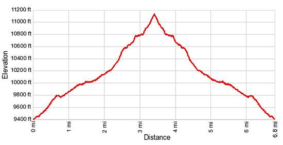
- Elevation: 9,350-ft. - 11,200-ft.
- Elevation Gain: 1,850-ft.
- Difficulty: moderate
- Trail Highlights: See Trail Intro
- Basecamp(s): Ouray
- Region: Southwest Colorado
This is a good hike for people looking for solitude and dramatic, up-close views of Mt. Sneffels. Don’t let the crowded parking lot deter you. Most hikers are headed for the Blue Lakes basin. You will have the Blaine Basin trail mostly to yourself.
Trailhead to Blaine Basin
Distance from Trailhead: 6.8 miles (round trip)
Ending/Highest Elevation: 11,200-ft.
Elevation Gain: 1,850-ft.
This hike shares the trailhead parking area with the Blue Lakes trail (see driving directions). Walk through the gate at the northern end of the parking lot and in a short distance reach a "Y" intersection. Turn left at the sign pointing to Blaine Basin (about 300-ft. from the gate.) The trail to the right goes to Blue Lakes.
In a few hundred yards the trail, an old logging road, crosses the East Fork Dallas Creek on a wood bridge. Follow the road as is ascends on moderate grades through spruce-fir forest, ignoring two minor roads branching to the right.
At 0.6 miles the trail crosses a low ridge and enters the Wilson Creek drainage. The grade abates as the path traverses aspen groves and meadows to meet Wilson Creek at 0.6 miles. Backtrack a brief distance from the crossing to find a rock cairn marking a trail heading right and leading to a makeshift bridge, constructed of logs, crossing the creek. Across the creek rejoin the road switchbacking up to the right.
Beyond the crossing reach a trail junction and turn right (east/southeast) on the trail signed for Blaine Basin. The trail to the left is the East Dallas trail that descends to the East Dallas Road.
For the next 0.8 miles the trail meanders through forest with intermittent meadows, paralleling the creek and crossing its two more times at 1.6 miles and 2.0 miles. Just after the third crossing look for a pretty waterfall cascading down the cliff face to the right (southwest) of the trail.
At 2.2 miles a sign marks a junction where the trail curves to the left (east). Ignore the unmarked trail to the right that leads to the base of the falls. Past the sign the path starts ascending on moderately-steep grades, reaching a signed junction with the Dallas Trail, branching left, at 2.3 miles. Continue straight ahead on the Blaine Basin trail.
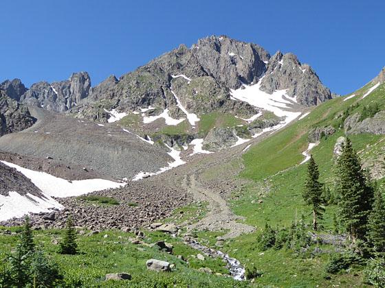
The rocky trail now climbs a steep slope through trees. Near the top of the slope the trail ascends through a small meadow and then turns right (south) toward the creek. Follow the trail as it climbs on moderate grades through trees and emerges in a beautiful meadow near Wilson Creek at 3.0 miles. This is lower Blaine Basin.
The meadow provides the first views of the north face of Mt. Sneffels (14,150-ft.), rising to the southwest. For even better views follow the trail as it crosses the creeks and climbs gently through meadows filled with wildflowers in season. Soon the trail starts climbing steep switchbacks up a hillside scattered with small trees, passing a sign for Blaine Basin at 3.2 miles. The smaller trees indicate the path of avalanches thundering down Sneffel’s north face.
After a short climb reach the upper basin (11,120-ft.) at 3.4 miles. The trail ends at a lovely viewpoint. In season the fields of the upper basin are filled with a spectacular display of wildflowers. Mt. Sneffels towers above the scenic basin with Kismet (13,694-ft.) and Cirque Mountain (13,680-ft.) rising to east of Sneffels. To the right (west) is Blaine Peak (12,910-ft.). Glacial moraines clearly illustrate the paths of ancient glaciers that once filled the basin.
A faint use trail is visible climbing the slope to a high bench between Mt. Sneffels and Blaine Peak. If time, energy and weather permit, the off-trail route to the bench offers up close views of Sneffels and bird’s-eye views of the basin.
Route to the Bench
Distance from Trailhead: 8.2 miles (round trip)
Ending/Highest Elevation: 12,080-ft.
Elevation Gain: 2,730-ft.
To reach the bench, walk a short distance up the valley and cross to the right (west) side of a rocky gully. On the other side of the gully continue ascending the valley until you find a good place to climb the grassy slopes to the use trail seen from the lookout. Follow the use trail as it switchbacks up the grassy slope to the south of Blaine Peak.
The trail fades as it reaches a gully carrying meltwater from the north slopes of Mt. Sneffels. Under good conditions you can cross the gully and find a trail on the other side that continues to the Blaine Mine. On my recent trip to the basin ice and loose rock filled the gully, preventing a safe crossing. In this case I simply climbed the grassy slopes to the right (northwest) of the gully until I reached the high bench overlooking Blaine Basin. From the bench enjoy lovely, up-close views of Mt Sneffel’s north face and Cirque Mountain to the southeast. This side trip gains almost 900 feet in just 0.7 miles, adding 1.4 miles to the round trip hiking distance.
Many people will be happy simply exploring the scenic upper basin and taking pictures of the wildflowers. When you are done enjoying the basin retrace your steps to the trailhead parking area.
Elevation Profile
| Buy the BookThis opinionated guide includes all the hikes in the Ouray, Telluride, Silverton and Lake City sections of the website plus info on local services and nearby attractions. |

Driving Directions
From Ouray: It takes 45-50 minutes to drive the 24 miles from Ouray to the Blue Lakes/Blaine Basin trailhead. The drive is quite scenic with views dominated by 14,150-ft. Mt. Sneffels and its neighboring peaks and ridges, almost all over 13,000-ft.
From the center of Ouray take Highway 550 heading north for just over 10 miles to Highway 62 in Ridgway. Turn left (west) on Highway 62. Drive 4.8 miles and then take a left onto County Road 7, marked Dallas Creek (the road use to be marked East Dallas Creek). It is easy to miss the turn while you are admiring the scenery to the south of the highway. In two miles CR-7 bears right where it meets CR-7A. Continue for a total of 9 miles on CR-7 through a beautiful valley to the parking area at the trailhead. Note: CR-7 turns into Forest Road 851.1 at the forest boundary.
From Telluride: From Telluride the trailhead is a 90 minute/44 miles drive. Drive west on West Colorado Avenue to Highway 145. Head west on Hwy 145 for 12.7 miles to where it dead ends at Highway 62 in Placerville. Turn a right (east) onto Highway 62 and drive 18.6 miles to County Road 7, marked Dallas Creek. Turn right onto CR-7. In two miles CR-7 bears right where it meets CR-7A. Continue for a total of 9 miles through a beautiful valley to the parking area at the trailhead. Note: CR-7 turns into Forest Road 851.1 at the forest boundary.
Road Conditions: Passenger car accessible if driven carefully. CR-7 is a dirt/gravel road that becomes rougher as it climbs to the National Forest boundary. Beyond this point the road maintenance deteriorates and you will need to dodge potholes and rocks.
Trail Resources
Trail Intro / Trail Photo Gallery / Trail Map
Basecamp(s) Information:
Ouray
Region Information:
Southwest Colorado
Other Hiking Regions in:
Colorado