Details: Rico-Silverton 
Distance: 5.2 miles (round trip)
San Juan National Forest, near Silverton in Southwest Colorado
By: Diane Greer
Hike Facts
- Distance: 5.2 miles (round trip)
- Elevation: 10,640-ft. - 12,468-ft.
- Elevation Gain: 1,828-ft.
- Difficulty: moderate-strenuous
- Trail Highlights: See Trail Intro
- Basecamp(s): Silverton / Ouray
- Region: Southwest Colorado
This nice half-day hike climbs on moderate to moderately-steep grades to a 12,450-ft. pass with panoramic views of the surrounding valleys and high peaks.
Trailhead to Rolling Pass
From the Rico-Silverton trailhead parking area (see driving directions below) walk south and almost immediately wade or rock-hop across the South Fork of Mineral Creek. The wide crossing will require getting your feet wet early in the season or during periods of high water.
Past the creek the trail wanders through meadows and soon enters the forest. From the meadows the summits of Fuller Peak (13,761-ft.) and Beattie Peak (13,342-ft.) are seen above the tree tops.
Cross a small stream draining the western flanks of Twin Sisters at 0.4 miles. Reach a second crossing of the South Fork after walking a little over a half mile. Beyond the second crossing the trail climbs steeply for a quarter mile and then breaks out of the trees at South Park, a large, scenic meadow. Twin Sisters (13,432-ft., 13,374-ft.) tower above the trail to the east while Rolling Mountain (13,693-ft.) rises to the west. Look for wildlife around a series of small ponds at the north end of the meadows.
The trail now ascends on easy grades up the meadow accompanied by terrific views of the Twin Sisters massif. Behind you, to the north, the high peaks to the north of the South Mineral Campground dominate the view. Look carefully and you will see the Clear Lake 4WD road snaking up the steep slopes of Peak 13,156-ft. The multi-hued summits of Beattie and Fuller Peaks, along with Fuller Peak’s eastern ridge, fill the skyline to the northeast
At 1.1 miles the trail crosses a small rockslide at the base of Rolling Mountain’s eastern ridge. Soon the trail starts ascending on moderate to moderately-steep grades through meadows scattered with clusters of willows and stunted spruce trees. Ahead views open to Peak 12,766-ft. at the head of the valley.
Enjoy ever improving views as the trail climbs. At 1.5 miles the trail rounds the eastern ridge of Rolling Mountain. Views now open to colorful Peak 13,050-ft., along the ridge to the south of Rolling Mountain. A short distance beyond pass a pretty falls set again a backdrop of Peak 13,050. Across the valley the southern end of Twin Sister is now in view. Behind you are fine views down the valley.
Past the waterfall the trail climbs steeply until you reach a small creek at 2.0 miles. The grade now abates a bit as the trail continues the stiff climb through alpine tundra to the pass. You are now over 12,000-ft. and above the timberline.
At 2.25 miles views open east to the Grenadier Range and the high peaks to the south of Silverton. A few large rock cairns help mark the trail, now a boot beaten path, as it climbs through alpine tundra toward the pass.
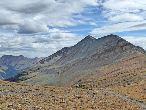
At 2.4 miles reach an unmarked junction with the Colorado Trail. Turn right (west) onto the Colorado Trail and climb two moderately-steep switchbacks to wind-swept Rolling Pass (12,450-ft.) at 2.6 miles. To the west/southwest Grizzly Peak (13,738-ft.) and Sliderock Ridge tower above the Cascade Valley. In the distance are the summits rising to the east of Rico. Closer at hand rugged Peak 13,050-ft rises above the northwest side of the ridge.
Turn around to the north for fine views the Twin Sisters and the high peaks rising above the head of the South Fork Valley. To the northeast views extend to Sultan Mountain (13,368-ft.) and Grand Turk (12,148-ft.).
For even better views, climb Peak 12,766-ft. to the east of the pass. This should add a little over a half mile (round-trip) and 30-45 minutes to the hike. From the summit Engineer Mountain (12,968-ft.) dominates the view to the south while Jura Knob (12,614-ft.) rises to the southeast. To the east/northeast are the high peaks of the Grenadier range and the summits soaring above the Silverton and the Animas Valley. To the west are more fine views of Grizzly Peak.
Hikers with the time and energy can return to the Colorado Trail junction and head southeast, following the trail for 0.3 miles to overlook above the West Lime Creek Valley. A tarn lies to the west of the trail. To climb Jura Knob, continue along the trail past the pond. Now leave the trail and plot your own course to the top of Jura Knob (12,614-ft.) in about 0.75 miles, with more panoramic views of the surrounding area.
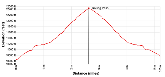
Elevation Profile
| Buy the BookThis opinionated guide includes all the hikes in the Ouray, Telluride, Silverton and Lake City sections of the website plus info on local services and nearby attractions. |

Driving Directions
From Silverton: From the intersection of Highway 550 and the turnoff to Silverton (Greene Street/CO Highway 110), drive north on Highway 550 for 2.0 miles to County Road 7/South Mineral Road. Turn left on County Road 7 (signed for the South Mineral Campground) and follow this good gravel road for 4.4 miles to the South Mineral Campground. Beyond the campground the road changes names to Forest Service Road 585 and gets rougher. Continue along the road for 2.2 miles to the Bandora Mine. Bear left at the mine to stay on FS 585, which descends to and then crosses a creek. The trailhead is a short distance beyond the creek, 7.0 miles from the turnoff from Highway 550.
From Ouray: Follow Highway 550 south from Ouray for 19.6 miles to CR 7. (The distance from Ouray is measured from the bottom of the switchback exiting the south end of town.) Make a sharp right onto County Road 7/ South Mineral Road. Follow this good gravel road for 4.4 miles to the South Mineral Campground. Beyond the campground the road changes names to Forest Service Road 585 and gets rougher. Continue along the road for 2.2 miles to the Bandora Mine. Bear to the left to stay on FS 585, which descends and then crosses a creek. The trailhead is a short distance beyond the creek, 7.0 miles from the turnoff from Highway 550.
Trail Resources
Trail Intro / Trail Photo Gallery / Trail Map
Basecamp(s) Information:
Silverton / Ouray
Region Information:
Southwest Colorado
Other Hiking Regions in:
Colorado