Details: Cross Mountain 
Distance: 6.6 miles (round trip)
Lizard Head Wilderness Area, San Juan National Forest, near Telluride in Southwest Colorado
By: Diane Greer
Hike Facts
- Distance: 6.6 miles (round trip)
- Elevation: 10,040-ft. - 11,940-ft.
- Elevation Gain: 1,900-ft.
- Difficulty: moderate-strenuous
- Trail Highlights: See Trail Intro
- Basecamp(s): Telluride
- Region: Southwest Colorado
A nice hike to the base of Lizard Head Peak, a distinctive 13,113-ft. rock spire towering above Highway 145 just south of Lizard Head Pass.
Trailhead to Junction with the Lizard Head Trail
Distance from Trailhead: 6.6 miles (round trip)
Ending/Highest Elevation: 11,940-ft.
Elevation Gain: 1,900-ft.
From the parking area the trail crosses a creek on a bridge and heads northwest, crossing a dirt track along the way. For the first half mile the Cross Mountain trail ascends through meadows with views to the east of the peaks and ridges around the Trout Lake area, including Sheep Mountain, Vermilion Peak, Golden Horn and Pilot Knob. At 0.4-miles pass the junction with the Groundhog Stock trail (heading left). Shortly after the junction the trail enters a spruce-fir forest with restricted views.
After 1.9 miles and an elevation gain of 1,200-ft, the trees give way to open meadows with ever improving views. Soon Lizard Head Peak comes into view along with the high peaks of the San Miguel Range, including Cross Mountain, Mt. Wilson and Gladstone Peak.
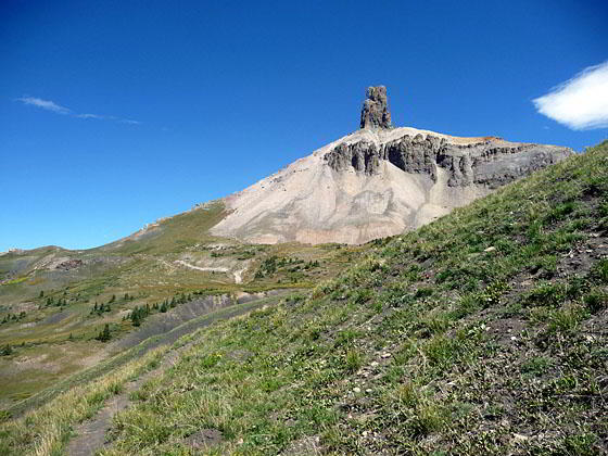
After climbing 1,900-ft. in 3.25 miles the trail arrives at the junction with the Lizard Head trail at the base of Lizard Head Peak, a distinctive 400-ft. rock spire. The 13,113-ft. peak, an old, eroded volcanic plug looming above the trail, is said to look like the gaping maw of a lizard with its face to the sky. From this vantage point it is hard to see the likeness.
Resist any temptation to climb the spire. Robert Ormes, publisher of one of the first guidebooks to the Colorado Mountains, issued the following warning about climbing the peak in his 1979 edition of the Guide to the Colorado Mountains:
“Lizard Head is the most difficult of Colorado summits to reach. In fact the rottenness of its 400-ft. tower makes safety too much a matter of luck for comfort. Returning visitors have formed the opinion that the peak has become noticeably rottener and more dangerous. Our advice when you reach the base, take [a] picture and go home.”
After admiring the pinnacle many people will turn around and return to the trailhead.
Optional Bilk Basin Overlook Extension
Distance from Trailhead: 0.6 miles (round trip)
Ending/Highest Elevation: 12,114-ft.
Elevation Gain: 180-ft.
A quick side trip to the Bilk Basin overlook is highly recommended if you have the time and energy. To reach the overlook, turn left at the junction and follow the Lizard Head trail as it ascends northwest for 0.3 miles through rocky meadows to a saddle. This wonderful vantage point features panoramic views of Bilk Basin and the jagged peaks and ridges of the San Miguel Range, including Mount Wilson, Gladstone Peak and Wilson Peak, towering above the west side of the basin. After soaking in the views, return to the Cross Mountain trail junction.
Lizard Head and old Railroad Grade to Cross Mountain trailhead
Distance from Trailhead: 11.7 miles (loop)
Ending/Highest Elevation: 12,147-ft.
Elevation Gain: 2,700-ft.
The hike can be turned into an 11.7-mile loop by taking a right at the Cross Mountain junction and following the Lizard Head trail to the top of Blackface Mountain in 2.4 miles. From here the trail descends to Lizard Head Pass on Highway 145 in 3.8 miles.
Complete the loop by walking west through the parking area to the road leading downhill toward the highway. Follow the road for a short distance. Just before the road reaches the highway you will see an unmarked trail heading right (southwest). Take this unsigned trail, which follows an old railroad grade paralleling the highway for 2.25 miles back to the Cross Mountain trailhead parking area. The total walking distance for the loop is 11.7 miles
Note: the views are better when the loop is done in reverse, starting at the Lizard Head Trail.
For more information see the Lizard Head and Railroad Grade route descriptions.
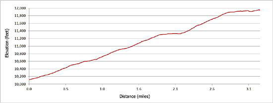
Elevation Profile
| Buy the BookThis opinionated guide includes all the hikes in the Ouray, Telluride, Silverton and Lake City sections of the website plus info on local services and nearby attractions. |

Driving Directions
Driving directions from Telluride: Drive south from Telluride on Colorado 145 over Lizard Head Pass (12.5-miles). Continue south for 2.2 miles and turn right onto a dirt road signed for the Cross Mountain trailhead.
Trail Resources
Trail Intro / Trail Photo Gallery / Trail Map
Basecamp(s) Information:
Telluride
Region Information:
Southwest Colorado
Other Hiking Regions in:
Colorado