Details: Kilpacker Trail to Navajo Lake 
Distance: 11.8 miles (round trip)
Lizard Head Wilderness, San Juan National Forest, near Telluride in Southwest Colorado
By: Diane Greer
Hike Facts
- Distance: 11.8 miles (round trip)
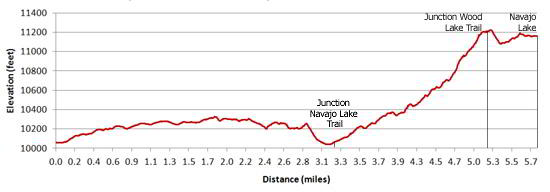
- Elevation: 10,060-ft. - 11,154-ft.
- Elevation Gain: 1,094-ft.
- Difficulty: moderate-strenuous
- Trail Highlights: See Trail Intro
- Basecamp(s): Telluride
- Region: Southwest Colorado
This alternative route travels through forest and then joins the Navajo Lake trail, a popular hike to a pretty alpine lake basin surrounded by high peaks. The combined route involves less elevation gain then the Navajo Lake trail but is 2.6 miles (round trip) longer.
Trailhead to Junction with the Navajo Lake Trail
Distance from Trailhead: 3.5 miles (one way)
Ending/Highest Elevation: 10,190-ft.
Elevation Gain: 404-ft.
The Kilpacker trail starts at a large sign board in the meadow west of Morgan Camp (see driving directions below). Follow the trail as it gently climbs west/northwest through meadows and enters a mixed conifer forest. The easy walk through the forest traverses an undulating landscape in and out of minor drainages. At 2.3 miles reach a trail junction and turn left (west) on the Kilpacker trail. (The trail continuing straight ahead leads to Kilpacker Basin and is used by climbers to reach El Diente and Wilson Peaks.)
The trail now drops through trees and intermittent meadows, losing 274-ft. over the 0.9 miles on its way to the West Dolores River. Cross the river on logs and follow the trail uphill for 0.2 miles to the signed junction with the Navajo Lake trail. Turn right (north) toward the lake basin.
Junction to Navajo Lake
Distance from Trailhead: 11.8 miles (round trip)
Ending/Highest Elevation: 11,154-ft.
Elevation Gain: 1,094-ft.
Beyond the junction the trail ascends, steeply at times, through forest and meadows toward the head of the valley. The meadows offer nice views to the northeast of El Diente’s rust-colored western ridge and the ridge defining Navajo Basin’s northern wall.
At 4.4 miles the trail starts a steep climb up the valley's north wall. The trail breaks from the trees at 4.7 miles and ascends a series of steep switchbacks through meadows sprinkled with wildflowers and dispersed groups of trees to the junction with the Woods Lake trail at 5.3 miles, gaining 870-ft. over 0.9 miles. Turn right (east) at the signed junction toward Navajo Lake.
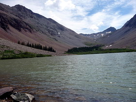
The trail climbs slightly, then drops 160-ft. and then climbs again to reach the western shore of Navajo Lake (11,154-ft) at 5.9 miles. The lake sits in a stark basin ringed by steep, rugged ridges. Gladstone Peak (13,913) rises above the headwall at the eastern end of the basin. El Diente (14,159-ft.) and Mount Wilson loom above the basin’s south rim, hidden from view by steep scree slopes. Wilson Peak (14,017) anchors the head of the basin’s northern wall but is also concealed from view.
This is the end of the day hike for most people. Backpackers camping at the lake and day hikers with excess energy (and good weather) can continue on the trail along the north side of the lake. Beyond the lake the trail climbs talus slopes to reach the upper end of the basin where it turns left (northwest) and climbs switchbacks up to the Rock of Ages saddle (13,000-ft.) and the junction with the new Rock of Ages trail, gaining 1,846-ft. in 2.4 miles. Total round trip from the Kilpacker trailhead to the saddle is 16.6 miles.
Elevation Profile
| Buy the BookThis opinionated guide includes all the hikes in the Ouray, Telluride, Silverton and Lake City sections of the website plus info on local services and nearby attractions. |

Driving Directions
Driving directions from Telluride: Drive south from Telluride on Colorado 145 for 17.9 miles and turn right onto the Dunton Road (#207). The turnoff is located 5.4 miles south of Lizard Head Pass. The gravel and dirt road ascends the hillside on a switchback and then traverses the northeast side of the Coal Creek drainage, crossing the creek in a little under 4 miles.
To reach the Kilpacker Trailhead follow the Dunton Road from the intersection with Colorado 145 for a 5.1 miles. Just past Morgan Camp watch for a dirt road on your right (north side of the road). Turn right and follow the road a short distance past a group of trees to an obvious parking area. The trailhead, designated with a large information board, is located to the west of the parking area.
Trail Resources
Trail Intro / Trail Photo Gallery / Trail Map
Basecamp(s) Information:
Telluride
Region Information:
Southwest Colorado
Other Hiking Regions in:
Colorado