Details: Argentiere Glacier and the Grand Balcon Nord 
Distance: 3.0 - 6.9 miles (round trip)
French Alps, near Chamonix in The French Alps
By: Diane Greer
Hike Facts
- Distance: 3.0 - 6.9 miles (round trip)
- Elevation: 6,470-ft. - 7,700-ft.
- Elevation Gain: 1,230-ft.
- Difficulty: moderate-strenuous
- Trail Highlights: See Trail Intro
- Basecamp(s): Chamonix
- Region: The French Alps
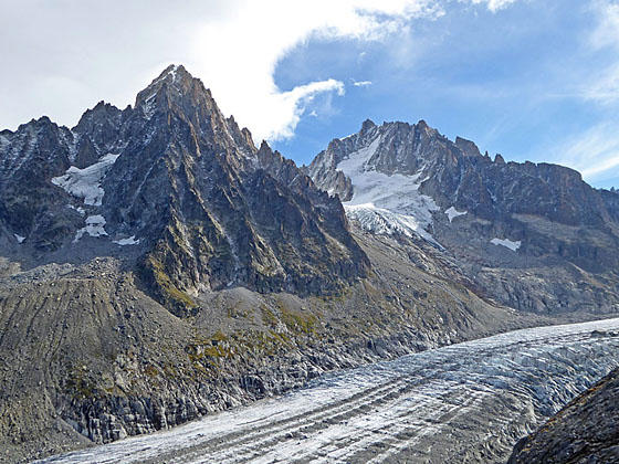
Visit the Glacier d’Argentiere, an impressive spectacle of rock and ice flowing down a scenic valley rimmed by jagged peaks. An optional return route descends the Grand North Balcony accompanied by fine views of the Aiguilles Rouges and le Brevent.
Trailhead to Argentiere Glacier Overlooks
Distance from Trailhead: 3.0 miles (round trip)
Ending/Highest Elevation: 7,700-ft.
Elevation Gain: 1,230-ft.
This hike starts with a ride up the Telepherique de Lognan/des Grandes Montets (Lognan/Grand Motets Cable Cars) to the Lognan Middle Station (see directions to the trailhead below). The ride eliminates a 2,400-ft climb from Argentiere that takes about 2 hours. If you wish to walk one-way, I suggest you walk downhill (back to Argentiere) at the completion of the hike or following the Grand Balcon Nord to les Tines (the better option).
From the top of the cable car station at Lognan, walk southeast on the broad track to the “Y” intersection at a signpost. Here we bear left (southeast) on the wide gravel track toward the Le Point de Vue, our destination, and Refuge d’Argentiere. The path soon curves to the east and starts climbing through meadows and scattered larches. The Aiguille Rouges fill the skyline across the valley to the west. Straight ahead views open to the Aiguille du Chardonnet towering above the Argentiere Valley.
At 0.4 miles ignore the broad track branching right. After a half mile reach a signed junction with the trail branching left toward the Chalet Refuge de Lognan. We continue straight ahead (east) on the trail signed for Le Point de Vue and Refuge d’Argentiere. The path now ascends through rocky meadows on moderate grades.
Reach the next junction at one mile. Here a short spur trail branches left to the Point de Vue Sur Le Glacier (the southern view point) with impressive close-up views of the snout of the glacier, fractured into deep crevasses and seracs, flowing down a steep incline. Waterfalls spill down slopes below the glacier’s retreating tongue. The craggy slopes of Aiguille du Chardonnet tower overhead.
After visiting the southern viewpoint return to the junction and follow the broad gravel track as it turns sharply right (south/southwest) and climbs steep switchbacks toward Le Point de Vue and Refuge d’Argentiere. Near the top of the third switchback a hiker’s trail heads straight uphill, short-cutting the broad trail that continues climbing switchbacks. At the top of the shortcut a waterfall tumbles down the slopes above the trail.
Beyond the waterfall the grade moderates and the hiker trail rejoins the broad track. A junction at 1.4 miles directs hikers off the broad trail to a Sentier Pietons (pedestrian trail) leading to an overlook above the glacier. A chaotic mass of ice pinnacles, blocks and deep crevasses cover the top of the ice sheet.
Just beyond the overlook the trail splits. A rugged path branches left toward the Refuge d’Argentiere. This route eventually crosses the glacier and should only be attempted by properly equipped and experienced parties.
We continue straight ahead, climbing along the moraine to the impressive viewpoint at 1.5 miles. Here views stretch up the river of ice to Mont Dolent soaring above the head of the valley. Aiguille du Chardonnet and Aiguille d’Argentiere tower above the glacier to the north. The Chardonnet Glacier spills down the slopes between the two peaks. Aiguille des Grand Montets rises above the trail. Fractured ice blocks tower above huge crevasses along the side of the glacier while bands of debris flow down the center of the ice sheet. Boulders and rock debris litter the base of the moraine.
It is possible to continue beyond the overlook by following the broad track, a ski service road, up the rugged east facing flanks of Grands Montets. The rocky dirt path ascends on very steep grades. Sections of the track are covered in loose talus, slowing forward progress. As you climb views open to the Glacier des Rognons spilling down the north facing slopes of Aiguille des Grands Montets.
At 2.1 miles the path reaches a small bench. Leave the trail here and travel to the end of the bench (2.2 miles) where an overlook offers panoramic views of the Argentiere Glacier. Aiguilles du Chardonnet, Aiguille d’Argentiere and the glaciers clinging to their slopes dominate the view to the east. The summit of Aiguille Verte rises to the south beyond Aiguille des Montets while Mont Dolent and the Aiguilles Rouges du Dolents (Red Needles) rim the head of the valley. To the northwest a sea of peaks rise above the Chamonix valley and beyond.
When you are done admiring the spectacle of ice and rock, retrace your steps to the Lognan lift station. Here you have three choices. Take the lift back for a 3.0 or 4.4 mile hike. Walk back to Argentiere or follow the Grand Balcon Nord (Grand Balcony North), descending to the Chamonix Valley at les Tines or Le Lavancher (see description below). If time and energy permit, I recommend the walk along the Grand Balcon Nord. The trail is more scenic and less steep than the trail dive bombing down to Argentiere.
Grand Balcon Nord to les Tines or le Lavancher
Distance from Trailhead: 6.9 miles (one way)
Ending/Highest Elevation: 3,750-ft.
Elevation Gain: -3,950-ft.
Note: This segment of the trail drops down to 3,750-ft. for an elevation loss of 3,950-ft. from the upper Argentiere Glacier overlook.
From the Lognan lift station, follow the broad track heading southwest signed for Agentiere and Le Lavancher The path initially passes through an area scattered with ski lifts and buildings, which we soon leave behind. Beyond the ski area the trail descends on easy grades through meadows and scattered trees. The Aiguille Rouges and le Brevent fill the skyline to the west/southwest.
At 3.5 miles reach a junction with the trail descending steep switchbacks to Argentiere. The Argentiere trail descends steep switchbacks and then follows roads back to the Agentiere train station or the bus at Les Chosalets (approx. 3 miles). We continue straight ahead on the trail toward Le Levancher.
Soon the broad track enters a pretty larch forest. Openings in the trees offer more views of the Aiguille Rouges. At 4.1 miles pass a second trail descending to les Chosalets and Argentiere. Again we stay on the path to Le Lavancher.
Beyond the junction the descent steepens a bit. At 4.4 miles the trail briefly breaks from the trees as it passes through the Le Pendant pastures. Here great views open to the Aiguille Rouges and le Brevent.
Reach a junction with the trail to the Prapator and Le Chapeau branching left at 4.6 miles. We stay on the trail to Le Lavancher and Les Tines, which now drops steeply through dense forest toward the Chamonix Valley. A few switchbacks facilitate the descent. At 5.8 miles pass a second trail branching left toward Le Chapeau. We continue the descent toward le Lavancher and les Tines. The towns are 20 minutes apart but les Tine is the better destination due to the convenience of both the bus and the train.
As the descent continues openings in the trees offer views of Mont Blanc and Aiguille du Midi. At 6.25 reach the upper end of Le Lavancher. Walk down a street for a short distance. Soon you will see a sign on the left pointing to a trail to Les Tines. Turn left on the trail that drops steeply through trees. When you reach the a minor road (Cheminde la Pierre) at 6.7 miles turn right and descend to the Routes d’Argentiere and then turn left to reach the train station and bus stop at 6.9 miles. (The mileage will be 7.9 miles if you hiked to the upper overlook above the Argentiere Glacier.)
Elevation Profile
Driving Directions
From Chamonix to Argentiere: From Chamonix take the train (18 minutes) or the #2 bus (25 minutes) to Argentiere. (If taking the bus get off the Grand Montets stop, right by the lift station.) At the Argentiere train station, exit the station and turn left (southwest) onto the Rue Charlet. Cross the train tracks and take the third left onto the Chemin sous la Grand. This street winds through an apartment complex, crosses the river on a bridge and then reaches the Grand Montets Lift station. Purchase either a one-way or round trip ticket to the middle station, Croix de Lognan. The longer version of this hike does not return via the lift but instead descends along the Grand Balcon Nord to train station at Les Tines.
For more information on train and bus schedules see the Chamonix Tourist Information site.
From Argentiere to Chamonix: From the lift station, either take the #2 bus or retrace your steps to the Argentiere Train Station and then take the train back to Chamonix.
For more information on train and bus schedules see the Chamonix Tourist Information site.
From Les Tines to Chamonix: The hike, descending along the Grand Balcon Nord, ends at the Les Tines Train Station. From here take the train or the #2 bus back to Chamonix.
For more information on train and bus schedules see the Chamonix Tourist Information site.
Trail Resources
Trail Intro / Trail Photo Gallery / Trail Map
Basecamp(s) Information:
Chamonix
Region Information:
The French Alps
Other Hiking Regions in:
France