Details: Col du Balme and Aiguilles des Posettes 
Distance: 6.8 miles (round trip)
French Alps, near Chamonix in The French Alps
By: Diane Greer
Hike Facts
- Distance: 6.8 miles (round trip)
- Elevation: 7,208-ft. - 7,687-ft.
- Elevation Gain: 1,800-ft.
- Difficulty: moderate-strenuous
- Trail Highlights: See Trail Intro
- Basecamp(s): Chamonix
- Region: The French Alps

The views are nonstop on this amazing hike visiting two panoramic summits, an incredible overlook and a scenic saddle on the Franco-Swiss border. After visiting the Col du Balme the hike is a roller coaster of ascents and descents. The views are worth the effort.
Col de Balme and Aiguilles des Posettes
Note: This trail is more difficult than implied by distance and net elevation due to the up and down nature of the trail and the final drop down to Le Tour.
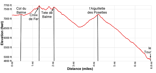
Elevation Information:
- Elevation at the trailhead (top of the lift): 7,208-ft.
- Elevation Col de Balme: 7,188-ft.
- Elevation at Croix de Fer: 7,687-ft.
- Elevation at Tete de Balme: 7,615-ft.
- Low Point below Tete de Balme: 6,552-ft.
- Elevation at Aiguilles des Posettes: 7,221-ft
- Elevation at Le Tour: 4,890-ft.
- Elevation Gain/Loss: 1,800-ft. /-4,150-ft.
This hike starts in le Tour with a ride up the Telecabine de Charamillon–Balme, a two stage lift. The first stage is a gondola to Chalets de Charamillon. Here we change for the Autannes chair lift to the top station (see directions to the trailhead below).
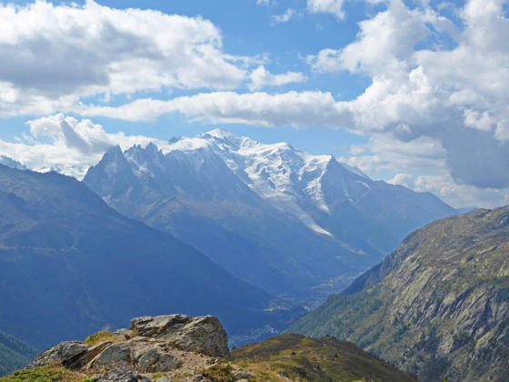
From the top of the chairlift walk north on the trail signed for the Col de Balme. The path traverses through meadows with fine views of Mont Blanc and the northern end of the Aiguille Rouges. Aiguille Verte rises above the ridge to the south. Along the way you will pass junctions for the trail to the Col du Posettes, which we will visit later on this hike.
Reach the Col de Balme (7,188-ft.) on the Franco-Swiss border at 0.4 miles. Nearby is the Refuge de Balme, a favorite stop along the Tour du Mont Blanc. Great views stretch down the length of the Chamonix Valley (Val de l’Arve) to Mont Blanc. The Aiguille Rouges rises to the southwest. To the north are distance views of the high peaks of the Bernese Oberland towering above the Rhone Valley.
A well signed junction at the Col points to the various trails dropping down to Trient and the Col de la Forclaz. We follow the trail north toward the Croix de Fer (Cross de Fer). In the next 0.1 miles you will pass another trail, branching right to Trient and a trail descending to Le Chatelard. We stay on the trail to Croix de Fer.
The path now ascends through meadows on moderate grades to a junction at 1.0 mile. Here a trail branches left to Catogne. We bear right on a narrow, rocky trail climbing on moderately-steep to steep grades along a ridge crest toward Croix de Fer. (Those with a fear of height may find the sheer drop-offs on either side of the trail uncomfortable. This trail should not be attempted if covered with snow and ice.)
Reach the Croix de Fer (7,687-ft.), a stunning overlook high above the north end of the Chamonix Valley and the Col de la Forclaz in Switzerland, at 1.3 miles. The overlook features amazing views of the high peaks towering above Lac Emosson to the west. Mont Blanc and Aiguille Verte form a stunning backdrop for the Col de Balme to the south. The summit of the Aiguille du Tour and the small portion of the Glacier du Trient are seen to the southeast. Tete de Balme, the north end of the Aiguille Rouges and the peaks rising above the Berard Valley fill the skyline to the southwest.
When you are done taking in the views, retrace your steps to the junction at 1.6 miles and bear right on the trail toward Catogne. The trail now climbs over the L’Arolette (7,644-ft) at 1.8 miles and then the Tete de Balme (7,615-ft.) at 2.0 miles. Each offers panoramic views of Lac Emosson area, the rugged peaks towering above the west side of Vallorcine and Argentiere. Mont Blanc, Aiguille Verte and nearby peaks fill the skyline along the east side of the valley.
From the top of Tete de Balme the trail descends on moderately-steep grades through meadows, passing by the Tete de Balme ski lift at 2.2 miles and then a junction with a trail branching left to the Col de Balme and the upper Autannes chair lift station at 2.4 miles. This trail is a good option if you wish to cut the hike short. Otherwise continue descending toward les Posettes.
As you descend enjoy stunning views stretching down the Chamonix Valley, rimmed by the Mont Blanc massif and the Chamonix Aiguille (Needles) to the east and the Aiguille Rouges to the west.
Reach an unmarked junction at 2.5 miles. Here a two-track heads straight downhill. Bear right to stay on the trail that descends on switchbacks. Soon views open to the Col des Posettes. The Aiguillette des Posettes rises beyond the col.
Arrive at the Col des Posettes (6,552-ft.) at 3.3 miles. Since leaving the Tete de Balme the trail has lost over 1,060-ft. in 1.3 miles. At the signed junction take the trail branching southwest to the Aiguillette des Posettes. The path now climbs on moderate to moderately-steep grades through meadows and then rugged outcroppings clad in bushes, reaching the craggy summit of des Posettes (7,221-ft.) at 4.4 miles.
The summit, which stands alone at near the northern end of the Chamonix Valley, features breathtaking views of Mont Blanc and the Chamonix Needles from Aiguille du Midi to Grand Montets. The Le Tour Glaciers clings to the slopes between Aiguille du Chardonnet and Aiguille du Tour. The peaks at the northern end of the Aiguille Rouges dominate the view to the southwest.
When you are done enjoying the views, descend the steep trail down the south side of the peak toward Le Tour. At the junction at 5.3 miles, turn left to stay on the trail to Le Tour. The path continuing straight ahead leads to the Col des Montets, a popular overnight stop on the Tour du Mont Blanc. Our path descends what seems like a never ending series of steep switchbacks to Le Tour (4840-ft.) at 6.8 miles, losing 2,381-ft. in 2.4 miles. At all junctions stay on the trail to Le Tour. The steep descent enjoys more fine views of the high peaks soaring above the Chamonix Valley. Unfortunately you will spend most of the descent watching where you place your feet.
If you wish to avoid the steep decent to Le Tour, from the summit of des Posettes, retrace your steps to the Col des Posettes at 5.4 miles. At the junction, turn right on the trail toward Charamillion and the top station for the gondola. Reach the gondola at 6.7 miles after losing 1,290-ft. Take the gondola down to Le Tour. Your knees will thank you.
Elevation Profile

Driving Directions
Chamonix to le Tour: The #2 or V2 buses are the easiest way to get to le Tour. The buses stop at the Chamonix Sud, Chamonix Center and Place Mont Blanc along with other locations in the Chamonix Valley. The ride from Chamonix Center to le Tour takes 26-34 minutes depending on the line. See the main Chamonix Tourist Information site for the latest bus and train schedules.
Le Tour to Chamonix: Take the #2 or V2 buses to return from le Tour to Chamonix. From le Tour it is a 26 – 34 minute ride back to Chamonix Center. See the main Chamonix Tourist Information site for the latest bus and train schedules.
Trail Resources
Trail Intro / Trail Photo Gallery / Trail Map
Basecamp(s) Information:
Chamonix
Region Information:
The French Alps
Other Hiking Regions in:
France