Details: Iceberg Lake 
Distance: 5.0 - 9.6 miles (round trip)
Glacier National Park, near Many Glacier in Glacier Natl Park, MT
By: Diane Greer
Hike Facts
- Distance: 5.0 - 9.6 miles (round trip)
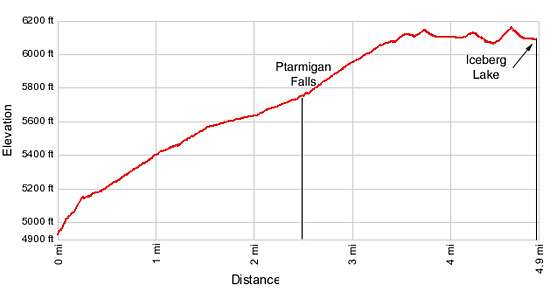
- Elevation: 4,960-ft. - 6,170-ft.
- Elevation Gain: 700-ft. - 1,210-ft.
- Difficulty: moderate
- Trail Highlights: See Trail Intro
- Basecamp(s): Many Glacier / St Mary
- Region: Glacier Natl Park, MT
One of the most popular hikes in the Many Glacier area ascends a scenic valley to stunning Iceberg Lake, an aquamarine jewel cradled beneath a dramatic steep-walled cirque. Along the way enjoy fine views of the peaks surrounding the Swiftcurrent Valley, Ptarmigan Falls and the Ptarmigan Wall.
To Ptarmigan Falls
Distance from Trailhead: 5.0 miles (round trip)
Ending/Highest Elevation: 5,660-ft.
Elevation Gain: 700-ft.
Please note: This trail passes through prime bear habitat. Keep an eye out for bears foraging along the avalanche slopes above the trail. Make noise while hiking, especially through areas of dense vegetation to insure you do not accidently surprise a bear. Park rangers are now advising hikers to carry bear spray while hiking.
From the Iceberg Lake/Ptarmigan Tunnel trailhead (see driving directions below), follow the trail as it heads north climbing steeply up rocky ledges, through meadows and stands of trees. In a short distance the trail passes a spur trail, branching to the right, heading back to the Swift Current area and Many Glacier Hotel. Bear left, staying on the main trail. At 0.2 miles the grade abates as the trail reaches a second junction. Follow the main trail as it curves to the left (northwest). The trail to the right (southeast) leads to the Many Glacier Hotel.
For the next 2.3 miles the trail ascends on easy to moderate grades through pretty meadows and forest along the lower slopes of Mt. Henkel (8,770-ft.). The first 0.75 miles of this section crosses wildflower-filled meadows with wonderful views to the west of Mt. Grinnell (8,851-ft.), Swiftcurrent Mountain (8,436-ft.) and Mt. Wilbur (9,321-ft.) towering above the beautiful Swiftcurrent Valley. Ahead the jagged profile of the Ptarmigan Wall rims the head of the Wilbur Creek drainage. Turn around for views of Allen Mountain (9,276-ft.) to the south.
At 1.8 miles the trail enters the forest. Small meadows and openings in the trees offer intermittent views of the surrounding peaks. Be sure to stop at the viewpoint for Ptarmigan Falls (5,659-ft.) at 2.45 miles. Trees partially obscure the view of the fall across the deep drainage.
Past the viewpoint the trail loops around the east side of the drainage and crosses a bridge over Ptarmigan Creek, the source of the falls. Rocking outcroppings above the falls to the southeast of the bridge offer a nice place to take a break and sit in the sun.
To Iceberg Lake
Distance from Trailhead: 9.6 miles (round trip)
Ending/Highest Elevation: 6,170-ft.
Elevation Gain: 1,210-ft.
Beyond the bridge the trail continues its ascending traverse, reaching a junction with the trail to the Ptarmigan Tunnel, branching to the right, at 2.6 miles. Continue straight ahead in the direction of Iceberg Lake.
At 2.9 miles the trees thin and soon give way to gorgeous meadows sprinkled with wildflowers. Views open to the steep-walled cirque towering above Iceberg Lake as well as the Ptarmigan Wall, a serrated mountain ridge separating the Wilbur Creek drainage from the Belly River Valley to the north. The cirque is anchored to the south by Mt. Wilbur. Iceberg Peak (9,146-ft.) towers above the lake to the west.
At 3.1 miles the trail curves to the west/southwest, traveling on easy grades along the base of the Ptarmigan Wall. Lush meadows on the wall’s lowers slopes of the wall are filled with a profusion of wildflowers including tall spires of beargrass, delicate alpine spiraea and pretty buttercups. The ever improving views of the cirque and the waterfalls on the outlet stream emanating from Iceberg Lake invite frequent stops, slowing your progress along this section of the path.
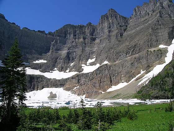
The trail curves to the south at 4.1 miles and crosses a bridge over Iceberg Creek at 4.4 miles. Lower Iceberg Lake, a small tarn, is seen a short distance to the west. The trail now climbs a low rise, gaining a little over 100-ft in 0.2 miles. As you cross the rise Iceberg Lake (6,094-ft.) springs into view.
This gorgeous alpine lake lies cradled beneath a stunning steep-walled cirque. The highest peaks in the cirque, Mt Wilbur and Iceberg Peak, soar over 3,000-ft. above the lake. Ice floes bob amid the lake’s aquamarine waters.
Follow the trail as it drops down to and ends at the lake shore, 4.8 miles from the trailhead. The lake is a very popular destination and can get quite crowded. To get away from the crowds follow the use trails traveling along the northeastern shore to find the perfect spot to appreciate the beautiful lake and the cirque’s towering granite walls.
After taking in the views retrace your steps to the trailhead, enjoying the views on the easy downhill hike back to the trailhead.
Note: Before starting your hike ask about current trail conditions at the Many Glacier Ranger Station. Trails in the Many Glacier area are occasionally closed due to bear activity.
Elevation Profile
Driving Directions
Driving Directions
From St. Mary: Drive north on US 89 for 8.5 miles and turn left onto Route 3, signed for Many Glacier. The turn is just before the town of Babb, MT. Continue along Route 3 for 12.4 miles to the large parking area at the end of the road. Just to the west of the reception building for the Swiftcurrent Motor Inn is a narrow road heading right (north) out of the parking lot and through the Swiftcurrent complex. Follow the road for 0.1 miles to a small parking area on the left (west) side of the road at the Iceberg Lake/Ptarmigan Tunnel trailhead. Parking is limited and fills early in the day. If no parking is available at the trailhead, park in the large parking area near the reception building and walk to the trailhead.
From the Many Glacier Hotel Complex: Head west on Route 3 for 0.9 miles to the large parking area at the end of the road. Just to the west of the reception building for the Swiftcurrent Motor Inn is a narrow road heading right (north) out of the parking lot and through the Swiftcurrent complex. Follow the road for 0.1 miles to a small parking area on the left (west) side of the road at the Iceberg Lake/Ptarmigan Tunnel trailhead. Parking is limited and fills early in the day. If no parking is available at the trailhead, park in the large parking area near the reception building and walk to the trailhead.
Trail Resources
Trail Intro / Trail Photo Gallery / Trail Map
Basecamp(s) Information:
Many Glacier / St Mary
Region Information:
Glacier Natl Park, MT
Other Hiking Regions in:
Montana