Details: Piegan Pass 
Distance: 9.0 miles (round trip)
Glacier National Park, near St Mary in Glacier Natl Park, MT
By: Diane Greer
Hike Facts
- Distance: 9.0 miles (round trip)
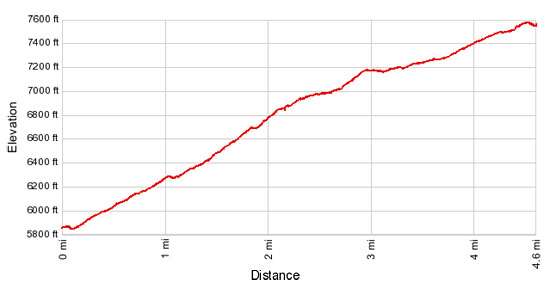
- Elevation: 5,840-ft. - 7,570-ft.
- Elevation Gain: 1,730-ft.
- Difficulty: moderate-strenuous
- Trail Highlights: See Trail Intro
- Basecamp(s): St Mary / West Glacier
- Region: Glacier Natl Park, MT
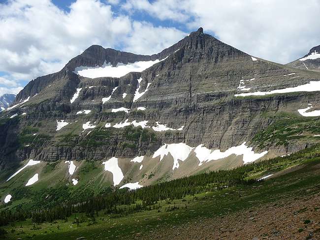
Splendid views of the peaks along the Continental Divide and rimming the Siyeh Creek Valley are the highlights of this scenic hike to Piegan Pass (7,570-ft.).
Piegan Pass
The trailhead for Siyeh Pass and Piegan Pass is located on the northeast side of the Siyeh Bend curve just east of where Siyeh Creek flows under the road. A brown sign, labeled Piegan Pass, marks the spot. (See driving directions below.)
From the road the trail drops down to and travels north along the right (east) side of Siyeh Creek. Cataract Mountain (8,180-ft.) and Mount Siyeh (10,014-ft.) rise above the head of the valley to the north. To the left (west) Piegan Mountain (9,220-ft.) looms above the trail.
At 0.2 miles the trail turns right curving to the south as it begins a moderately steep traverse through stunted pines and then thick spruce-fir forest, rock-hopping across a series of small creeks along the way. Two logs span a wider creek crossing at 1.0 mile. Rock hop across the next creek, located just a tenth of a mile beyond.
Reach the junction with a spur trail branching to the right (south) and dropping to the Going-to-the-Sun Road at 1.2 miles. Bear left, following the Piegan Pass trail as it curves to the north, crossing two more streams. Two logs facilitate the first crossing during high water. Otherwise both creeks are easily crossed on rocks without getting your feet wet.
At 1.4 miles the trail traverses a small meadow sprinkled with wildflowers. The open area provides you first views of Going-to-the-Sun Mountain (9,642-ft.) rising above the trees to the right (east). Soon the trees thin and the trail passes through intermittent meadows with partially obscured views of Piegan Mountain across the valley.
The lower slopes of Matahpi Peak (9,365-ft.), to the east, form the backdrop for a pretty creek spanned by a wooden bridge at 2.3 miles. Beyond the crossing the grade abates as the trail passes through stands of stunted trees and pretty meadows with fine views of Mt Siyeh (10,014-ft.) rising to the north, Piegan Mountain (9,220-ft.) to the west and Pollack Mountain (9,190-ft.) to the northwest.
Reach the signed junction with the Siyeh Pass trail branching to the right (east) at 2.7 miles. Turn left (northwest) at the junction toward Piegan Pass. A short distance beyond the junction the trail crosses a log bridge over a creek draining the southern slopes of Mt. Siyeh.
The trail ascends on moderately steep grades through stands of subalpine larch, dwarf firs and stunted pines interspersed with beautiful meadows sprinkled with wildflower. The meadows afford good view of the southwestern flanks of Mt. Siyeh towering above the north side of the valley.
As you climb views open to Piegan Pass, the saddle on the ridge to the northwest running between Piegan Mountain (9,220-ft.) and Cataract Mountain (8,180-ft.). Pollack Mountain (9,190-ft.) and the serrated profile of the Bishop’s Cap (9,127-ft.), rise beyond the pass to the west along the Continental Divide.
At 3.0 miles the grade abates as the trail follows an ascending traverse along the southwestern slopes of Mt. Siyeh and the ridge running between Mt. Siyeh to the east and Cataract Mountain to the west. This section of the trail enjoys ever improving views of the peak around the pass. Mt. Piegan and the Piegan Glacier fill the skyline to the west while Mt. Jackson (10,052-ft.), the Jackson Glacier, Blackfoot Mountain (9,574-ft.) and the Blackfoot Glacier dominate the view to the south. To the southeast, Matahpi Peak and the Going-to-the-Sun Mountain tower above the eastern side of the valley.
At 3.7 miles the trial starts a moderately steep climb along the south slope of Cataract Mountain, reaching Piegan Pass (7,570-ft.) at 4.5 miles. The south side of the broad pass offers excellent views of Mt. Siyeh, Matahpi Peak and the Going-to-the-Sun Mountain. Pollock Mountain looms above the pass to the west.
For the best views to the north of the pass, follow the trail across the pass and down the other side for a short distance (0.1 miles). At the top of the first switchback use trails head west to scenic perches high above the Cataract Creek Valley. From these vantage points enjoy stunning views of the peaks along the Garden Wall on the Continental Divide, including the Bishop’s Cap and Mount Gould (9,553-ft.), towering above the west side of the valley. Distant views extend north to Mount Grinnell (8,851-ft.), Mt. Wilbur (9,321-ft.) and Mt. Henkel (8,770-ft.) in the Many Glaciers area.
Most hikers turn around at the pass and retrace their steps to the trailhead or, if time and weather permit, hike to Siyeh Pass. Another popular option is to continue over the pass and descend on steep switchbacks down the Cataract Valley, passing pretty Morning Eagle Falls along the way. Six mile beyond the pass the trail reaches a junction with the spur trail dropping down to Josephine Lake (left/north). Continue straight ahead, descending on easy grades along the south side of Josephine and Swiftcurrent Lakes to the trailhead at the Many Glacier Hotel, 12.9 miles from Siyeh Bend.
Elevation Profile
Driving Directions
From St. Mary, MT: Head west on the Going to the Sun from for 15.2 miles to to Siyeh Bend, a prominent hairpin curve on the road, 2.8 miles east of Logan Pass. Limited parking is available at pullouts on the east and west side of the road on both sides of the sharp curve. The Piegan/Siyeh Pass trailhead is located on the northeast side of the curve to the east of where Siyeh Creek flow under the road.
From West Glacier, MT: – Head north/northeast on the Going to the Sun Road for 34.8 miles to Siyeh Bend, a prominent hairpin curve on the road, 2.8 miles down the east side of the divide from Logan Pass. Limited parking is available at pullouts on the east and west side of the road on both sides of the sharp curve. The Piegan/Siyeh Pass trailhead is located on the northeast side of the curve to the east of where Siyeh Creek flow under the road.
Glacier National Park Shuttle Bus: The Glacier National Park Shuttle bus, which operates from the beginning of July through the first week of September (check current schedule on the park’s website: http://www.nps.gov/glac/planyourvisit/shuttles.htm), runs in two sections. On the west side of the Park the buses run from Apgar Visitor Center to Logan Pass. The east side shuttle runs from the St. Mary Visitor Center to Logan Pass. Siyeh Bend is stop 6 on the east side shuttle coming up from St. Mary and the first stop going down from Logan Pass.
Trail Resources
Trail Intro / Trail Photo Gallery / Trail Map
Basecamp(s) Information:
St Mary / West Glacier
Region Information:
Glacier Natl Park, MT
Other Hiking Regions in:
Montana