Details: Cobalt Lake and Two Medicine Pass 
Distance: 9.0 - 15.4 miles (round trip)
Glacier National Park, near Two Medicine in Glacier Natl Park, MT
By: Diane Greer
Hike Facts
- Distance: 9.0 - 15.4 miles (round trip)
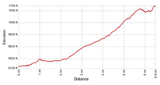
- Elevation: 5,180-ft. - 7,641-ft.
- Elevation Gain: 1,390-ft. - 2,502-ft.
- Difficulty: moderate-strenuous
- Trail Highlights: See Trail Intro
- Basecamp(s): Two Medicine / St Mary
- Region: Glacier Natl Park, MT
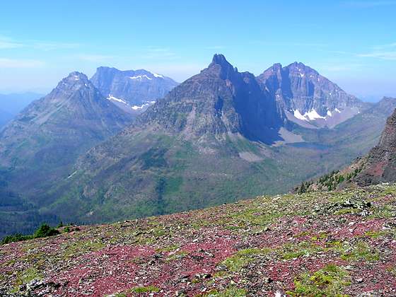
This hike travels up a long, pretty valley to Cobalt Lake and then climbs to a scenic pass on the Continental Divide with panoramic views of the peaks surrounding the Park Creek Valley to the west along with Sinopah Mountain, Mt. Rockwell and Painted Teepee Peak.
To Cobalt Lake
Distance from Trailhead: 9.0 miles (round trip)
Ending/Highest Elevation: 6,570-ft.
Elevation Gain: 1,390-ft.
Before starting your hike check current trail conditions at the Two Medicine Ranger Station. Trails in the area are occasionally closed due to bear activity.
To Cobalt / Two Medicine Pass via the South Shore Trail
The South Shore trail is somewhat of a misnomer. The trail does not traverse the south shore of Two Medicine Lake but instead travels well to the southeast of the lake. That being said it is a pleasant trail that travels on easy grades through forest and pretty meadows.
The trail starts at the south end of the parking area near the boat dock. Follow the forested trail as it briefly heads south and then curves to the southwest. Pass the junction for the Paradise Point trail at 0.3 miles. (The trail to Paradise Point heads west for 0.6 miles to a small beach on the lake shore with great views of the surrounding peaks.) A short distance beyond the junction the trail turns southeast.
At 0.6 miles the trail again curves to the southwest, traveling through pretty meadows to the southeast of a marshy area with small ponds. Rising Wolf Mountain (9,513-ft.) rises above the trees to the northwest. Sinopah Mountain towers above the head of the lake while Never Laughs Mountain (7,641-ft.) and Appistoki Peak (8,164-ft) dominate the view to the south/southeast.
The ponds and marshy areas are a great place to see wildlife and birds during the early morning and early evening. Moose are purported to frequent the ponds but I have not been lucky enough to spot one.
The trail plunges back into the forest at 0.75 miles, occasionally passing through small meadows. At 1.1 miles the trail crosses a log bridge over Aster Creek. A short distance past the bridge, reach the junction with the Aster Falls trail branching to the left. Continue straight ahead.
At 1.6 miles the trail travels along a boardwalk over a marshy area of the trail. Open meadows, 0.3 miles beyond, offering nice views of Mt. Sinopah (8,271-ft.). Cross Paradise Creek on a swing bridge at 2.2 miles and then follow the trail as it curves to the west, reaching the junction with the trail to Two Medicine Pass at 2.5 miles. Turn left on the Two Medicine Pass Trail. The continuation of the South Shore trail to the right leads to the boat dock at the head (west end) of the lake, Twin Falls/Upper Two Medicine Lake and the North Shore trail.
[Skip the next section and continue reading “To Cobalt Lake”]
Cobalt Lake/Two Medicine Pass via the boat dock at the head (west end) of Two Medicine Lake
Hikers can ride the tour boat on Two Medicine Lake (5,164-ft.) to shorten the distance to Cobalt Lake/Two Medicine Pass by 1.2 miles (one-way) or 2.4 miles (round-trip). The boat travels to the head (west end) of the lake where trails connect to a variety of destinations, including Cobalt Lake and Two Medicine Pass.
The cruise across the lake is accompanied by a commentary on the Blackfoot Indian folklore surrounding the Two Medicine Valley and offers stunning views of Painted Teepee Peak (7,650-ft.), Sinopah Mountain (8,271-ft.), Lone Walker Mountain (8,502-ft.), Finsch Peak (9,225-ft.) and Rising Wolf Mountain (9,513-ft.). Consult the Glacier Park Boat Company (http://www.glacierparkboats.com/) website for schedules and tour costs.
From the boat dock at the head of the lake a trail heads west on easy grades, crossing boardwalks as it passes through a marshy area. In a short distance reach a trail junction where you turn left onto the South Shore trail. (The trail straight ahead leads to Twin Falls, Upper Two Medicine Lake and the Dawson Pass Cutoff trails.)
The South Shore trail passes through trees and then crosses a meadow cleared by avalanches tumbling down the eastern slope of Sinopah Mountain. From the meadow views extend north across Two Medicine Lake to Rising Wolf Mountain and northwest to Flinsch Peak.
The trail reenters the trees at 0.75 miles and soon crosses a wooded ridge. At the next trail junction, 1.2 miles from the start, turn right toward Two Medicine Pass. The trail to the left is the continuation of the South Shore trail leading to the boat dock at the foot (east end) of Two Medicine Lake. Upon reaching a second trail junction, at 1.4 miles, turn right on the Two Medicine Pass trail. (The trail to the left returns to the foot of Two Medicine Lake via the South Shore trail.)
To Cobalt Lake
In the next two sections the trail mileage is listed as A/B where A reflects the distance from the boat dock and B is the distance from the South Shore trailhead.
Follow the Two Medicine Pass trail as it heads southwest on easy grades through shrubby fields, meadows sprinkle with beargrass and small stands of trees. The rugged slopes of Sinopah Mountain tower above the trail to the west. Ahead views open to Painted Tepee Peak and Grizzly Mountain. Soon the trail enters thick forest, obscuring the views.
Cross a branch of Paradise Creek on a log bridge and just beyond arrive at base of Rockwell Falls (5,463-ft.). The pretty waterfall is composed of a series of cascades spilling over rock ledges. A section of the upper falls can be seen through the trees.
The trail now climbs moderately-steep switchbacks up a rocky bench through open forest. A use trail at the top of one of the switchbacks leads to a viewpoint for the upper falls. As you ascend the rugged cliffs running between Mt. Rockwell and Sinopah Mountain dominate the view to the northwest. The aptly named Painted Tepee Peak rises to the southwest. Grizzly Mountain looms above the head of the Paradise Creek valley, to the south, while Never Laughs Mountain (7,641-ft.) rims Paradise Creek valley to the east.
At 3.1/4.3 miles the grade abates a bit. The trail now travels through a beautiful “U”-shaped valley clad in stunted conifers and small meadows, initially beside the outlet stream for Cobalt Lake. At 3.4/4.6 miles a horse trail breaks off to the left and crosses the stream. The hikers trail continues along the south side of the creek, climbing rocky ledges and small meadows with wonderful views of steep, craggy cliffs on the ridge between Mt. Rockwell and Sinopah Mountain.
Soon the trail moves away from the creek and travels through forest. At 4.1/6.3 miles views open to a pretty waterfall tumbling from the steep slopes beneath the cliffs. The trail now climbs moderately steep grades through meadows and stands of trees, crossing Cobalt Lake’s outlet stream at 4.25 miles. A small meadow beyond the crossing offers fine views of Mt. Rockwell (9,272-ft.) towering above the northwestern end of the valley.
Beyond the crossing a short steep climb leads to the junction with the spur trail to Cobalt Lake (6,570-ft.), 4.4 miles from the boat dock and 6.5 miles from the South Shore Trailhead. The lake lies tucked beneath the cliffs of Chief Lodgepole Peak, 0.1 miles below the trail. Two campsites are located across the outlet stream, near the lake’s northeastern shore. If time permits, work your way around to the east side of the lake for nice views of Mt. Rockwell towering above the western end of the valley.
For many day hikers Cobalt Lake is a good turnaround point. Parties with the time and energy will want to continue beyond the lake, climbing the ridge at the head of the valley. Two Medicine Pass is located at the southeast end of the ridgeline.
To Two Medicine Pass
Distance from Trailhead: 15.4 miles (round trip)
Ending/Highest Elevation: 7,641-ft.
Elevation Gain: 2,502-ft.
To reach the ridge and Two Medicine Pass, turn right at the junction with Cobalt Lake and follow the trail as it climbs steeply through pretty meadows sprinkled with wildflowers to the saddle on the ridge beneath the south face of Mt. Rockwell. As you ascend enjoy fine views of Cobalt Lake, Mt. Rockwell and the rugged ridge rimming the valley to the north. Near the top of the climb look southeast to see the peaks rising along the Continental Divide beyond Two Medicine Pass.
Reach the saddle at 5.4/6.6 miles. The craggy east face of Mt. Rockwell soars above the saddle while a small tarn lies nestled in a shallow bowl to the west of the trail.
At the saddle the trail turns left (south/southeast) and climbs a set of steep, rocky switchbacks to the top of the ridge at 5.6/6.8 miles. The trail now traverses the top of the ridge to Two Medicine Pass at 6.5/7.7 miles, crossing the summit of Chief Lodgepole Peak (7,682-ft.) along the way. From the pass the trail drops down to the Upper Park Creek Valley.
Panoramic views from the top of the ridge stretch west to Vigil Peak (8,593-ft.), Battlement Mountain (8,830-ft.), Statuary Mountain (8,250-ft.) and Church Butte. Lake Isabel lies nestled in the small valley to the north of Vigil Peak. Eagle Rib Mountain (8,290-ft) rises to the southwest. Vistas extend northeast from Cobalt Lake to Two Medicine Lake with great views of Sinopah Mountain and Painted Tepee Peak. Mt. Rockwell and the ridge extending to Sinpopah dominate the view to the north.
Beyond the pass the trail drops down a series of switchback into the Upper Park Creek Valley. Day hikers, after taking the views, will need to retrace their steps back to the trailhead.
Be advised that the ridge is exposed and can be very windy. Watch for approaching storms and retreat to lower elevations if you see the weather turning for the worse.
Elevation Profile
Driving Directions
From Two Medicine: From US Highway 2 in Two Medicine, turn north on Montana-49 N. Drive 4.1 miles on 49-N and turn left on Two Medicine Road. Travel along Two Medicine Road to 7.3 miles to the parking lot at the end of the road. The trail along the south shore of Two Medicine Lake starts at the south end of the parking area.
From St. Mary: Head south on Rt. 89 for 18.9 miles and turn right onto MT 49 S. Follow the narrow, twisty road for 7.5 miles and then turn right onto Two Medicine Road. Travel along Two Medicine Road to 7.3 miles to the parking lot at the end of the road. The trail along the south shore of Two Medicine Lake starts at the south end of the parking area.
Via Boat: The Glacier Park Boat Company (http://www.glacierparkboats.com/) runs boat tours on Two Medicine Lake. The boats travel to the head of the lake where trails connect to a variety of destinations. Hikers can ride the boats either one way to round trip to shorten hiking distances.
The dock is located near the foot of the lake. To reach the boat dock from US Highway 2 in Two Medicine, turn north on Montana-49 N. Drive 4.1 miles on 49-N and turn left on Two Medicine Road. Travel along Two Medicine Road to 7.3 miles to the parking area at the end of the road. The dock and kiosk for purchasing tickets is at the southwest end of the parking area. During the height of the summer it is advisable to get reservations a day ahead of time. See the Glacier Park Boat Company website for departure schedules, costs and contact information.
Trail Resources
Trail Intro / Trail Photo Gallery / Trail Map
Basecamp(s) Information:
Two Medicine / St Mary
Region Information:
Glacier Natl Park, MT
Other Hiking Regions in:
Montana