Details: Numa Ridge Lookout 
Distance: 11.8 miles (round trip)
Glacier National Park, near West Glacier in Glacier Natl Park, MT
By: Diane Greer
Hike Facts
- Distance: 11.8 miles (round trip)
- Elevation: 4,030-ft. - 6,960-ft.
- Elevation Gain: 2,930-ft.
- Difficulty: moderate-strenuous
- Trail Highlights: See Trail Intro
- Basecamp(s): West Glacier
- Region: Glacier Natl Park, MT
A lovely drive up Glacier’s North Fork Valley leads to Bowman Lake. Here the Numa Ridge trail climbs its namesake ridge to a working fire tower with fine views of the peaks rising along the southeast side of the lake and west across the North Fork Valley.
Trailhead to Numa Ridge Lookout
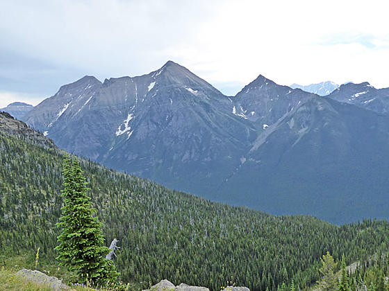
From the Bowman Lake parking area (see driving directions below), follow the broad trail for 0.1 miles to the foot of Bowman Lake (4,030-ft.). Here enjoy terrific views of the high peaks ringing Bowman Lake. North and South Cerulean Peaks, Square Peak and Rainbow Peak (9,891-ft.) tower above the southeast side of the lake while the Numa Ridge and Numa Peak (9,0003-ft.) rise to the north. Boulder Peak (8,528-ft.), Mount Custer (8,883-ft.), Chapman Peak (9,406-ft.) and Thunderbird Mountain (8,790-ft.) fill the skyline beyond the head of the lake.
Turn left and walk along the wide lakeshore path for 0.1 miles to a junction. Here the Akokala Creek Trail branches left (west). We continue along the Bowman Lake Trail toward the Numa Ridge Lookout Trail. The trail curves around the foot of the lake, heading north/northeast through trees lining the lakeshore. Openings offer nice views of the peaks on the far side of the lake.
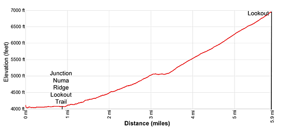
Reach a junction at 0.9 miles. Here the Numa Ridge Lookout Trail bears left, ascending on moderate grades, with a few steep pitches, through forest up the southeast facing flanks of Numa Ridge. The forest is predominately lodgepole pine and Douglas fir with a few scatter larches. As you gain elevation the forest slowly changes to a spruce-fir forest with some limber pines. Pretty wildflowers are scattered along the undergrowth in season.
At 2.9 miles the grade moderates. The trail now ascends on easy grades, passing to the west of a small pond that lies hidden by the dense forest. The respite is short-lived. At 3.4 miles the trail resumes climbing on moderately-steep grades.
At 3.8 miles the trail curves to the right (northeast). Soon the trees begin to thin and at 4.3 miles intermittent views open to Bowman Lake and the small pond. Across the lake Cerulean Ridge’s North and South Peaks along with Square Peak and Rainbow Peak join the scene.
As you climb the views continue to improve. At 4.95 miles the trail turns northwest. From this vantage point the Guardhouse and the Sentinel appear to the northwest of Rainbow Peak. The trail now starts climbing switchbacks up the ridge. Along the way enjoy fine views of the peaks towering above the far side of the lake.
Reach the Numa Ridge Fire Lookout at 5.9 miles. The Lookout, constructed in 1935, is still in use. Views from the Lookout stretch west to the peaks rising beyond the North Fork Valley. Reuter Peak (8,763-ft.) and the Kintla Peak massif rise to the north above the Akokala Valley while Akokala Lake lies nestled in the valley to the southwest. To the east Rainbow Peak, Square Peak and the Cerulean Ridge dominate the view.
Retrace your steps back to the trailhead when you are done enjoying the views.
Elevation Profile
Driving Directions
From West Glacier: Drive northwest on the Going-to-the-Sun Road for 2 miles and then turn left onto the Camas Road. Drive 11.7 miles to the end of Camas Road and then turn right onto the unpaved North Fork Road. Follow the North Fork Road for 12.9 miles and turn right onto the Polebridge Loop. Drive 1.0 miles to a “T” intersection and turn left onto Glacier Drive.
Follow Glacier Drive for 4.0 miles. Along the way the road crosses a bridge over the North Fork of the Flathead River and bears left on the continuation of the road around the Polebridge Ranger Station. At the end of Glacier Park Road turn left on the Inside of the North Fork Road. Stay on the Inside Road for 0.2 miles and then turn right onto the Bowman Lake Road. Drive 5.5 miles on the bumpy and dusty Bowman Lake Road to the day use parking area adjacent to the campground.
Check on current road conditions at the Apgar Visitor Center before starting your trip.
Trail Resources
Trail Intro / Trail Photo Gallery / Trail Map
Basecamp(s) Information:
West Glacier
Region Information:
Glacier Natl Park, MT
Other Hiking Regions in:
Montana