Rinerhorn (Jatzmeder) to Sertig 
Distance: 4.5 miles
near Davos in Eastern Switzerland
By: Diane Greer
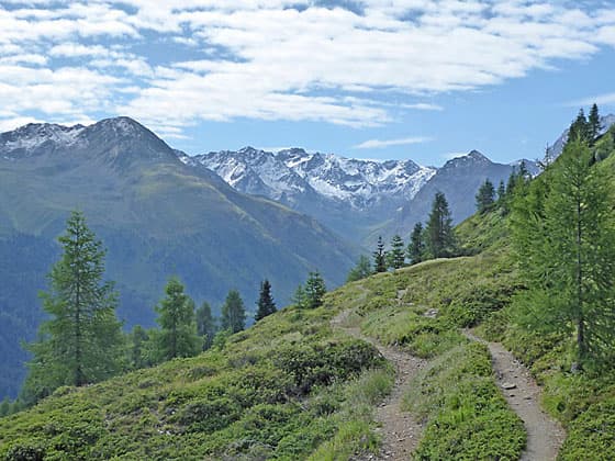
Peaks rising above the Chuealp Valley
This beautiful half-day hike, through meadows and forests, showcases the high peaks rising above the Landwasser Valley and the summits soaring above the head of the scenic Sertig Valley, including the Mittaghorn, Plattenflue and Piz Ducan.
- Distance: 4.5 miles (One Way)
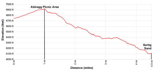
- Elevation: 6,725-ft. at Trailhead
Maximum elevation - 6,914-ft. - Elevation Gain: 189-ft.
- Difficulty: easy-moderate
- Basecamp: Davos
- Region: Eastern Switzerland
Trail Description - Rinerhorn (Jatzmeder) to Sertig
This moderately-easy half day hike features fine views of the peaks of the Landwasser and Sertig Valleys. Starting at Jatzmeder, the top station for the Rinerhorn Gondola, an easy trail travels through meadows to the picnic area at Abirugg, accompanied by non-stop views of the Landwasser Valley. Here the trail curves into the Sertig Valley, descending on moderate grades to Sertig Dorfli and Sertig Sand, two lovely alps near the head of the scenic Sertig Valley. The restaurant at Sertig Sand, features a panoramic terrace, with great views of the high peaks towering above the Sertig Valley to the south.
While the broad trail to Abirugg is shared with bikes, beyond the picnic area the trails split, with the path for hiker traveling above the trail for bikes. The two trails occasionally merge for short distances through difficult terrain. The separate trails make for a very pleasant hike/ride for everyone.
Directons from the Rinerhorn (Jatzmeder) to Sertig
Take the bus or train from Davos to Glaris and ride the Rinherhornbahn gondola to its top station at Jatzmeder (6,725-ft). Behind the gondola station, follow yellow hiking signs on the path heading north/northwest toward Sertig Dorfli. The broad path, shared with bikers, rises gently through meadows dotted with trees. Panoramic views extend west to the high peaks above the Landwasser Valley, including Valbellahorn, Amselflua, and Tiejer Flua.
After a mile, reach Abirugg, a picnic area high above the confluence of the Landwasser and Serig Valleys. This is a popular picnic spot with far-reaching views of the Landwasser valley. At the north end of the valley the Weissfluh towers above Davos, cradled along the valley floor. Near the picnic area is a trail junction. We take the trail toward Sertig Sand and Sertig Dorfli that curves to the left, traveling high above the southwest side of the Sertig Valley. Other trails drop to the valley floor or climb to the Rinerhorn.
The first section of our trail, from Jatzmeder to Abriugg, was shared with bikers heading to Sertig. Once you pass Abirugg, the routes diverge into separate paths with the hiking trail running above the biking trail, although they merge periodically for short stretches through difficult terrain.
The hiker path now heads south/southeast, descending on easy grade into the Sertig Valley. Views encompass the peaks rising above the Sertig Valley. At its head, the Sertig Valley forks into the Chuealp Valley, to the left, and the Ducan (Dukan) Valley, to the right. As we continue along the trail views open to the summits soaring above the Chuealp Valley.
At 1.5 miles the hiking and biking trails merge. A short distance beyond, the trail drops down moderately-steep switchbacks into a drainage and crosses a creek. After a short climb out of the drainage, the path resumes its descent through trees and then splits at 2.0 miles in to separate hiker and biker trails.
At 2.2 miles the hiker and biker trails merge to cross a second drainage. Past the drainage the trails again split. Reach a junction at 2.4 miles (Alp Saltenueo) with a trail branching left and dropping down to the valley floor. Our trail continues straight ahead, now descending on steeper grades toward Sertig Dorfli and Sertig Sand as it travels through trees and small meadows with intermittent views of the ridge rimming the east side of the Sertig Valley.
At 3.2 miles the trails again converge, cross a creek and then split. The grade abates and the path soon emerges from the trees with nice views of the Sertig valley and the high peaks rising to the southeast.
Reach a junction at 3.6 miles. The trail to the left descends to Sertig Dorfli, where you will find a restaurant and bus stop with service back to Davos. I recommend staying on the trail to up the valley to Sertig Sand where there are better views along with a second restaurant and bus stop.
Past the junction lovely views soon open to the Mittaghorn, Plattenflue and Piz Ducan, soaring above the east side of the Ducan Valley. Sertig Dorfli lies nestled in the meadows along the valley floor.
At 4 miles the bike path converges with the hiking path and then drop down to the Walserhuus Sertig, a restaurant and hotel, in Sertig Sand at 4.5 miles. In front of the Walserhuus is a bus stop with great views of the Weissfluh and nearby peaks towering above the Landwasser Valley. Nearer at hand are views of the pretty white church in Sertig Dorfli, set amid emerald green meadows.
Around the back of the Walserhuus is a restaurant with a panoramic terrace featuring lovely views of the high peaks of the Ducan Valley soaring above picturesque meadows. Yellow hiking signs near the restaurant list a variety of destination up the Chuealp and Ducan Valleys. If time and energy permit, extend the walk with the short hike up the Sertig Valley to the Ducan Waterfall.
Elevation Profile
Driving Directions
From Davos: Take the bus or the train to Davos Glaris and then cross the road to the Rinherhornbahn gondola. Find the bus or train stop nearest your accommodations and then check the SBB website/app to determine the best options. On the SBB website / SBB app the bottom station for the gondola will be listed as Davos Glaris (Talst.Jatzmeder) or Davos Glaris, Bergrestaurant Jatzmeder, Rinerhornstrasse. You can purchase a combined ticket that includes the one-way trip to Jatzmeder, the top station of the gondola, and the return bus ticket from Sertig Sand to Davos.
From Sertig Sand to Davos: In front of the Walserhuus at Sertig Sand, find a bus sign and bench for buses going to Davos. The bus returns to Davos every hour or half.hour (depending on the season) during the day. Check the schedule on the SBB website / SBB app before starting the hike so you know the frequency and the last return trip to Davos.
Trail Resources
- Trail Photo Gallery
- Trail Maps
- Basecamp(s) Information: Davos
- Region Information: Eastern Switzerland
- Other Hiking Regions in: Switzerland