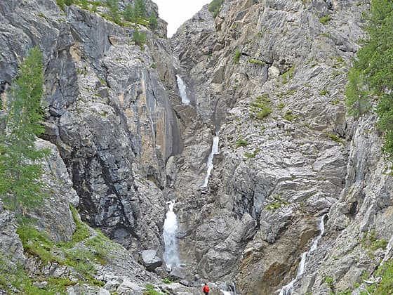
Near the viewpoint for the falls
Easy hike up the lovely Sertig Valley beside a rushing stream to the dramatic Ducan Waterfall tumbling down a rugged chasm in three stages.
- Distance: 1.8 miles (RT)
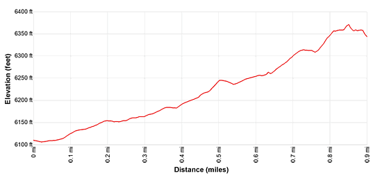
- Elevation: 6,099-ft. at Trailhead
Maximum elevation - 6,360-ft. - Elevation Gain: 261-ft.
- Difficulty: easy
- Basecamp: Davos
- Region: Eastern Switzerland
Trail Description - Sertig to the Ducan Waterfall
This easy, family friendly hike travels up the bucolic Sertig Valley beside a rushing stream accompanied by great views of the Mittaghorn, Plattenflue and Piz Duncan towering above the valley. In less than half a mile trail turns right into the Ducan Valley, now ascending gentle grades beside the Ducanbach stream.
Soon views open to the dramatic Ducan Waterfall, tumbling down a rugged chasm in three stages. Follow the trail to a viewpoint near the foot of the falls for up-close views of this dramatic waterfall. Gravel areas with benches and rocky perches offer get places for a picnic or to simply sit and enjoy the spectacle. Kids will love playing amid the rocks.
Most of the way to the falls is passable with a baby carriage or wheelchair.
Direstions to the Ducan Waterfall from Sertig
Take the bus from Davos to Sertig Sand and get off at the last stop in front of the Walserhuus Restaurant/Hotel in Sertig Sand (6,099-ft.). From the bus stop enjoy fine views to the north of the Weissfluh towering above the Landwasser Valley.
Walk south along the road skirting the east side of the hotel/restaurant. Just past the parking lot (left), find the yellow trail signs. Continue straight ahead on the alp road toward the Wasserfall (waterfall).
The trail ascends on easy grades through pastures along the east side of the valley. The Sertigbach, a pretty stream, meanders down the idyllic valley beside the trail. Ahead the Mittaghorn, Plattenflue and Piz Duncan, towering along the southeast side of the Ducan Valley, dominate the view.
Reach a “Y” intersection at 0.4 miles and turn right (south) on the path toward the Wasserfall. (The trail to the left (southeast) ascends the Chuealp Valley toward Sertig Pass). Our trail crosses a bridge over the Sertigbach and ascends on easy grades along the east side of the Ducanbach, the stream draining the Ducan Valley.
At 0.7 miles reach a junction. Stay on the trail leading to the Wasserfall. The trail to the left climbs to the Fanezfurgga. Soon views open to the beautiful Ducan Falls, a photogenic waterfall tumbling 200-ft. down a rugged, rocky chasm in three stages. Behind you are views stretching north up the Sertig Valley to the Weissfluh rising above the Landwasser Valley.
As you head toward the falls note the large gravel shelf alongside the stream, showing the extent of the stream during the spring melt. Two benches, and some large rocks amid the gravel shelf, offer nice spots for picnics and to take in the views.
The trail gets more rugged as you approach the waterfall and soon ends at a viewpoint. Many hikers go beyond the viewpoint, climbing through the rocky area beneath the falls to get better photos. Use extreme caution if you choose to go further. The rocks can be wet and slippery. A fall could have serious consequences.
When you are done enjoying the waterfalls, turn around and retrace your steps to the trailhead.
Elevation Profile
Driving Directions
Davos to Sertig: From the Bahnhof (train station) at Davos Platz (the southwest end of town), board the bus to Sertig. Purchase a ticket for Sertig Sand, the last stop on the line. The scenic ride up the Sertig Valley takes about 27 minutes. Regularly scheduled buses return to Davos via the same route. A schedule is posted at the bus stop of Sertig Sand. You can also check the current schedules at the SBB website/SBB app. On the SBB site look for the bus going from Davos Platz, Bahnhof to Sertig, Sand.
Note: Buses and trains travel between Davos Dorf and Davos Platz. The train ride takes three minutes. Buses take a variety of routes through the town. Pick up a bus schedule at the Tourism Office at the Davos Dorf Bahnhof or near the Sportzentrum in the middle of town, or consult the SBB website/SBB app/SBB app to find the stop closest to your accommodations.
Trail Resources
- Trail Photo Gallery
- Trail Maps
- Basecamp(s) Information: Davos
- Region Information: Eastern Switzerland
- Other Hiking Regions in: Switzerland