Details: Munt La Schera 
Distance: 7.0 - 8.0 miles (one way)
near Scuol in Eastern Switzerland
By: Diane Greer
Hike Facts
- Distance: 7.0 - 8.0 miles (one way)
- Elevation: 6,457-ft. - 8,484-ft.
- Elevation Gain: 2,162-ft.
- Difficulty: moderate-strenuous
- Trail Highlights: See Trail Intro
- Basecamp(s): Scuol
- Region: Eastern Switzerland
The Munt la Schera trail, in the Biosfera Val Mustair and the Swiss National Park, ascends through scenic meadows sprinkled with wildflowers to the broad summit of Munt la Schera where panoramic views extending to the summits in the Swiss National Park, Italy’s Stelvio National Park and beyond.
Munt La Schera
Note: Cumulative elevation gain and loss for this hike: +2,162-ft./-2,729-ft. (+659-meters/-832-meters)
The point-to-point hike can be started from the bus stops at Il Fuorn or Buffalora in the Biosfera Mustair Nature Park to the east of Zernez. I recommend starting at Buffalora since it is higher and requires less elevation gain. From the Buffalora bus stop (see trailhead directions below) cross the road to the trail signs listing Alp Buffalora (20 m) and Munt la Schera (2 ½ h).
The trail to Munt la Schera descends south through meadows and soon crosses the rocky stream bed of the Ova dal Fuorn on a temporary wood bridge. Along the way enjoy fine views of Piz Daint rising to the southeast. A short stint through scattered trees leads to a second crossing of the rocky stream bed for the Aua da Murtarol.
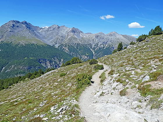
Beyond the second crossing the path climbs on moderate grades through meadows and scattered trees. Be sure to turn around for views of Piz Nair and the summits rising above Val Nuglia and Val Fuorn to the north/northwest. After 0.5 miles (0.8 km) reach a junction at Alp Buffalora 6,686-ft. (2038 meters). Bear right onto a farm road toward Munt la Schera.
The trail curves around the Alp buildings and then ascends through trees. At 0.9 miles (1.4 km) the grade abates a bit as the trees give way to meadows. Piz Daint fills the skyline to the southeast while Piz Nair dominates the view to the north. The farm track now curves to the right (west) as it ascends through meadows. Ahead views open to Munt Buffalora.
Reach a junction at Alp Marangun at 1.2 miles (1.9 km). Here we leave the farm road and turn right (northwest) on a trail toward Munt la Schera. The path ascends through meadows, low lying scrubs and scattered trees along the north facing slopes of Munt Buffalora. After cresting a rise Munt Chavagl, a pyramid-shaped peak, is seen to the west.
The grade briefly abates as the trail passes a signed junction with a path to tunnel entrance for a medieval iron ore mine. We continue straight ahead. Soon the moderate ascent resumes through alpine meadows scatter with stunted conifers. As you climb views open to the rugged peaks rising above Val Fuorn to the north.
At 2.3 miles (3.7 km) the grade abates as the path curves to the left (west/southwest). Turn around for great views of the summits rising above the Pass Dal Fuorn to the northeast. Munt Chavagal towers overhead. Soon the trail crosses the border into the Swiss National Park at a saddle (7,810-ft. / 2,380-meters) at 2.5 miles (4 km) between Munt Chavagl and Munt Buffalora.
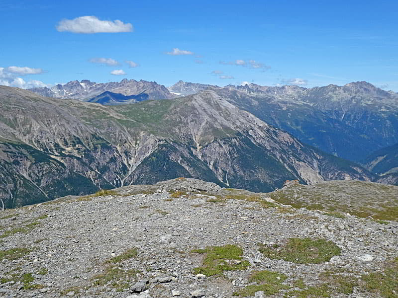
Here beautiful views open to the peaks in Stelvio National Park in Italy along with Piz da l’Acqua and Piz dal Diavel rising above the Val dal Spol in the Swiss National Park. The snowcapped peaks in the distance are Piz Bernina and Piz Zupo.
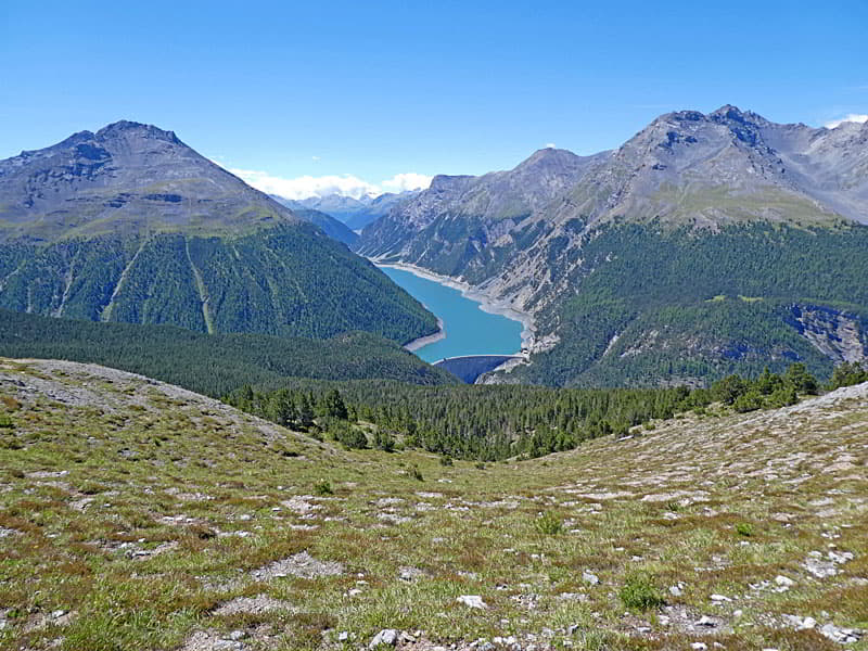
The path initially traverses along the eastern flanks of Munt Chavagl and then descends on moderately-easy grades, curving to the left (west) around the south end of an unnamed peak. Here vistas expand to encompass the entire ridge rimming the west side of the Val dal Spol in the Swiss National Park along with the peaks rising above the Lago di Livigno in Italy. Ahead views open to Munt la Schera.
Soon the trail drops into a drainage and then ascends to a junction at 3.3 miles (5.3 km). Turn right to climb Munt La Schera. Hikers who want to avoid the steep climb can continue straight ahead on the easy path heading west toward Alp la Schera. This trail meets the path coming down from Munt la Schera in 0.6 miles (1 km). Bypassing the climb to the summit reduces the hike by 1.0 miles (1.6 km) for a total hike of 7.0 miles (11.3 km).
To Munt la Schera
The path to the summits climbs steeply through meadows up the southeastern flanks of the peak accompanied by great views of the peaks to the south. As you ascend, look for the elusive Edelweiss, a pretty, white flower, growing amid the rocky meadows. Dense hair covers the petals to protect them from the cold and ultraviolet light.
At 3.8 miles (6.1 km) the grade abates as the trails reaches the broad ridge leading to the summit. Take a break here to enjoy the views of the peaks to the south including the distant views of the glacier-clad summits of the Bernina Alp to the south. The path now ascends on easy to moderate grades to a junction at 4.2 miles (6.8 km). Turn right on the spur trail that ascends to the broad, flat summit 8,484-ft. (2586-meters) at 4.3 miles (6.9 km).
From the summit enjoy far-reaching views of the peaks towering above Lago di Livigno, a long slender reservoir, in Stelvio National Park in Italy and the snow-capped peaks in the Bernina Alps. To the southwest the peaks rimming the Val Dal Spol and beyond in the Swiss National Park fill the skyline. To the north a sea of summits rise above the Val dal Fuorn. To the west/northwest views extend down the length of the Val Dal Fuorn to the mountains rising above Zernez and the lower Engadine.
When you are done taking in the views, descend the spur trail to the junction and turn right on the trail descending toward Alp la Schera and Il Fuorn. The trail drops steeply down the Munt la Schera’s southern slopes, reaching a junction with the trail heading west toward Alp la Schera at 4.9 miles (7.9 km). Near the junction you will find more Edelweiss.
To Alp la Schera and Il Fuorn
Turn right (west) at the junction toward Alp la Schera. The trail descends steeply through meadows along the south facing flanks of Munt la Schera accompanied by fine views of the peaks to the south. Soon the trail curves to the northwest and enters a forest before emerging on the meadows of Alp la Schera at 5.7 miles (9.2 km). Descend through the meadows to cabin and the Alp la Schera National Park rest area 6,860-ft. (2,091-meters) at 5.9 miles (9.5 km). Here benches offer a scenic place to eat lunch and take in the views of the peaks to the south/southwest.
After taking a break, continue along the trail through the meadows on easy grades. Soon the path curves to the north and enters a mixed forest. A short distance beyond the trail curves to the northeast, resuming its steep descent. Along the way the grade briefly abates as the trail traverses a rock slide.
Reach Car Park #5 and the highway at 7.7 miles (12.4 km). Carefully cross the road and turn right toward Il Fuorn. The trail now climbs gently to Hotel Parc Naziunal Il Fuorn and the Il Fuorn bus stop at 8.0 miles (12.9 km). Schedules posted at the stop list the times the bus returns to Zernez.
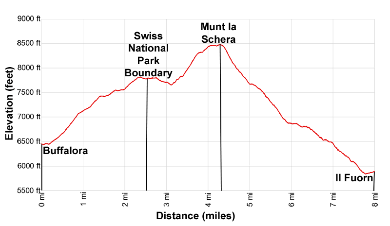
Elevation Profile
Driving Directions
From Scuol to Buffalora; From the train station in Scuol, take the train headed toward Pontresina and get off at Zernez. Walk a short distance to the Zernez Stazium (Zernez Train Station) bus stop, located on the east side of the station. Take the #811 bus headed toward Mals and get off at the Buffalora P10 bus stop. Visit the SBB website and the SBB app for the current schedules. The entire trip take an hour and seven minutes.
Il Fuorn to Scuol: The bus stop at Il Fuorn is located in the parking lot adjacent to the Hotel Parc Naziunal Il Fuorn. Take the #811 bus bound for Zernez Staziun (Zernez Train Station). Get off at the train station and catch a train bound for Scuol-Tarasp. The entire trip will take an hour and 11 minutes. At the Scuol train station you can either walk back to your accommodations or catch a local bus. Visit the SBB website and the SBB app for the current schedules.
Trail Resources
Trail Intro / Trail Photo Gallery / Trail Map
Basecamp(s) Information:
Scuol
Region Information:
Eastern Switzerland
Other Hiking Regions in:
Switzerland