Panorama Trail - Muottas Muragl to Alp Languard 
Distance: 4.3 miles
near St Moritz in Eastern Switzerland
By: Diane Greer
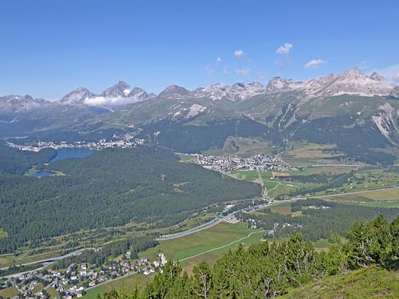
The Albula Alps soaring above St Moritz and Celerina
The Panorama Trail, an easy traverse between Muottas Muragl and Alp Languard, features nearly nonstop views of the Upper Engadine and Bernina Valleys. Highlights include alpine meadows, glacier-clad peaks, and broad panoramas of the Albula and Bernina Alps.
- Distance: 4.3 miles (One Way)
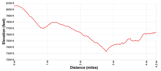
- Elevation: 8,051-ft. at Trailhead
Maximum elevation - 7,631-ft. - Elevation Gain: -420-ft.
- Difficulty: easy-moderate
- Basecamp: St Moritz
- Region: Eastern Switzerland
Trail Description - Panorama Trail - Muottas Muragl to Alp Languard
Muottas Muragl sits high above the northeast side of Val Bernina near its junction with the Upper Engadine Valley, offering one of the region’s finest viewpoints. Here sweeping panoramas stretch across the Upper Engadine to the Albula Alps, while the Bernina Alps dominate the southwest skyline. To the northeast, Piz Muragl and Piz Languard form a dramatic wall of peaks above the overlook.
Two great hikes showcase theses jaw-dropping views, traveling between the top of the funicular station at Muottas Muragl and the chairlift at Alp Languard. The Panorama Trail is the easier and lower option, traversing alpine meadows with nearly continuous views. The more demanding route via the Segantini Hut, rated as moderately-strenuous, climbs higher for even broader vistas but includes steep ascents, descents, and a few obstacles.
The Panorama Trail is a great alternative for families or anyone seeking an easy walk with terrific views. The day starts with a scenic funicular ride to Muottas Muragl, situated near the confluence of the Upper Engadine and Bernina Valleys. Here overlooks preview the coming attractions, with impressive views of high peaks towering above Val Muragl and the Upper Engadine Valley.
The remainder of the hike features nonstop scenery of both the Albula and Bernina Alps. Refreshments are available at Unterer Schafberg, the low point of the traverse, before an easy to moderate climb leads to Alp Languard where a second bergrestaurant offers a panoramic terrace with more great views. Total elevation gain for the hike is 360-ft with 1,030-ft of elevation loss.
Hiking Directions
Ride the Muottas Muragl Funicular from the Punt Muragl Talstation (valley station) to Muottas Muragl (8,051 ft.), perched high above the Bernina Valley near its confluence with the Upper Engadine. From the top station enjoy stunning views of the Albula Alps towering above the Upper Engadine Valley, with St. Moritz, Celerina, and Samedan nestled on the valley floor. To the south, the magnificent, glacier-clad peaks of the Bernina Alps, including Piz Bernina, Piz Scerscen, Piz Roseg, and Piz Glüschaint, dominate the view, while Piz Vadret and Piz Muragl fill the skyline above Val Muragl.
From behind the station, follow yellow trail signs southeast toward Alp Languard and Chana Segantini (Segantini Hut). The trail descends on moderate grades through pastures, passing Alp Muottas, and then levels out at 0.9 miles on the floor of Val Muragl. Ignore trails to the right dropping to Punt Muragl and Samedan.
A short distance beyond, just before a stream crossing, pass a trail branching left toward Lej Muragl (Lake Muragl) and Fcla. Muragl (Muragl Pass). Continue straight ahead, crossing the wood plank bridge over the stream draining Val Muragl.
At 1.1 miles, reach a junction where the high route branches left, climbing toward the Segantini Hut and Alp Languard. We bear left (west) toward Unterer Schafberg, Alp Languard and Puntraschinga (a Romansh derivation of Pontresina) on the Panorama Trail.
The path now descends on gentle grades through rocky meadows and a short rockslide with well-laid stonework to facilitate the crossing. The rocks soon give way to meadows with scattered trees where views open to Piz Ot and Piz Nair rising above the Upper Engadine Valley.
The trail soon curves left around the northwest ridge of Munt da la Bes-cha, revealing panoramic views up the Upper Engadine Valley, with Celerina, St. Moritz, and Lake St. Moritz framed by the Albula Alps.
At 1.9 miles, pass a junction with a steep trail dropping to Punt Muragl and Puntraschigna. -Our trail continues curving to the left with more great views of the Upper Engadine. Soon, dramatic views open across the Bernina Valley to Piz Bernina, Piz Zupo, and Piz Palu rising above Val Roseg and the Morteratsch Valley, two side valleys branching off the Bernina Valley. You are now traversing high above the Bernina Valley. Be sure to look back for striking views of the Albula Alps.
The trail briefly enters trees at 2.6 miles, with intermittent views of the Bernina peaks. At 2.8 miles, reach the low point of the hike and a junction signed to Unterer Schafberg, where a short spur leads to a small restaurant with excellent views. Beyond this point, the trail climbs on easy to moderate grades through forest. A short distance past the restaurant, a trail branches left, climbing steeply toward the Segantini Hut. We stay on the signed trail toward Alp Languard.
At 3.0 miles the trail emerges from the trees, crosses a few streams and travels through trees. At 3.8 miles reach an area where a rock slide destroyed part of the trail. Here a large culvert now goes under the slide, safely bypass the obstacle.
Beyond the culvert reach a “Y” intersection. The path to the right descends to Puntraschigna. We bear left toward Bergstation Languard/Alp Languard. The path climbs briefly, then traverses open meadows with outstanding views of the Albula and Bernina Alps. Alp Languard soon comes into view, framed by Piz Palü and Piz Zupò.
Reach Bergstation Languard (7,631-ft) at 4.3 miles. The Bergrestaurant Alp Languard sits beside the chairlift to Pontresina and offers a panoramic terrace for a relax meal or snack before descending by lift. Beside the restaurant a trail drops to Pontresina. I recommend taking the chair lift down and saving your knees!
The hike can be done in either direction, though starting from Alp Languard involves more ascent (1,030-ft. versus 360-ft). Alternatively, hike 2.0-2.5 miles from Alp Languard, to the slopes beneath Munt da la Bes-cha before returning to Alp Languard. This out-and-back option delivers fine views and avoids the funicular, which is more expensive than the chairlift.
Elevation Profile
Driving Directions
From St. Moritz: From the St. Moritz Bahnhof, take the #4 bus toward Pontresina Post, which stops at Punt Muragl (the bottom station of the Muottas Muragl Funicular, located in Val Bernina to the northwest of Pontresina. There are other bus routes that stop at Punt Muragl leaving from St. Moritz, St. Moritz Bad and Pontresina. Get bus information from the local tourist office SBB website/SBB app to find the closest stop to your accommodations. On the SBB the the St. Moritz Train station is St. Moritz, Bahnhof and the Muottas Muragl Funicular station is Punt Muragl, Talstation.
From Alp Languard to St. Moritz: Take the chairlift from Alp Languard to the bottom station in Pontresina. Exit the chair lift and walk down the street. Cross Via Cruscheda and descends to the next street, Via Maistra, the main street in Pontresina. Turn left (southeast) on Via Miastra and walk down the street to the Pontresina Post bus stop. Catch the #4 bus in the direction of Maloja and get off at St. Moritz Bahnhof. Alternatively, take the #1 bus heading to Silvaplana, Rundella Curtins and change at St. Moritz Schulhausplatz for a #1 bus heading to the Bahnhof. The ride takes 21-35 minutes. Several bus lines stop at Pontresina Post going to destinations in St. Moritz, Pontresina and other nearby towns. Check the SBB website/SBB app to find the best bus to get you back to your accommodations. On the SBB the Alp Languard Chairlift is Pontresina (Sesselb. Languard) and the St. Moritz Trainstation is St. Moritz, Bahnhof.
Trail Resources
- Trail Photo Gallery
- Trail Maps
- Basecamp(s) Information: St Moritz
- Region Information: Eastern Switzerland
- Other Hiking Regions in: Switzerland