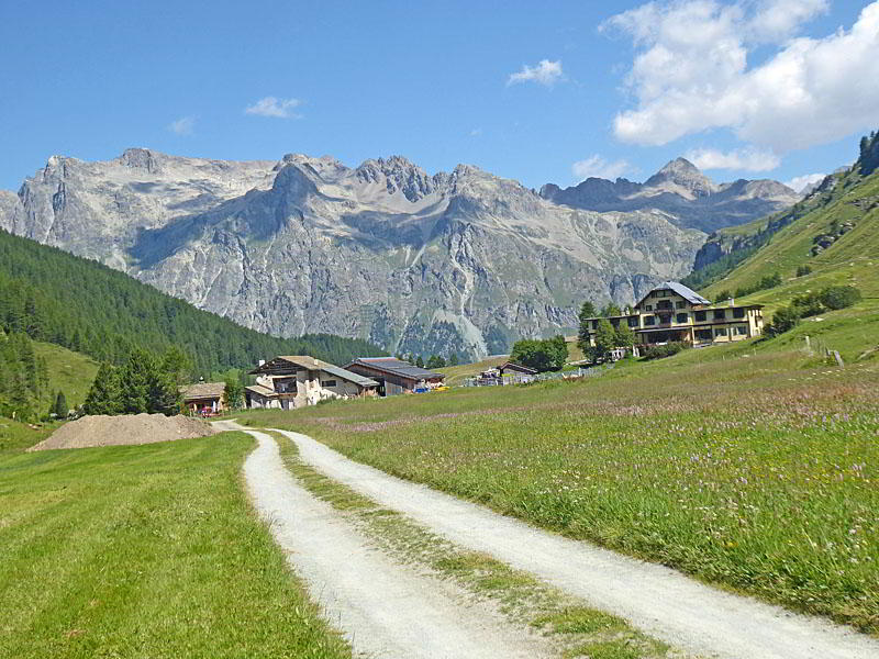
Heading toward Alp Muot Selvas
An easy to moderate walk up the beautiful, pristine Fex Valley visits charming villages set amid lovely meadows. Along the way enjoy wonderful views of the high peaks rising above the northwest side of the Upper Engadine Valley and the glacier-clad cirque at the head of the valley.
- Distance: 2.5 - 8.9 miles (RT)
- Elevation: 5,930-ft. at Trailhead
Maximum elevation - 6,800-ft. - Elevation Gain: 870-ft.
- Difficulty: moderate
- Basecamp: St Moritz
- Region: Eastern Switzerland
Trail Description - Val Fex
Val Fex is considered by many to be one of the most beautiful side valleys in the Engadine. Lying to the south of Sils, the car-free valley is protected by a 1954 agreement that prohibits parking, ski apparatus, power lines and new holiday homes.
Today easy to moderate trails ascend the enchanting, unspoiled Fex Valley, passing through beautiful wildflower-filled meadows, shady larch forests and charming villages. Along the way hikers enjoy stunning views of the summits rising above the northwest side of the Upper Engadine Valley and the glacier-clad cirque, anchored by Piz Tremoggia and Piz Fora, at the head of the Fex Valley.
Several destinations in the valley allow hiking parties to tailor their day to a gentle stroll, a moderate walk or a longer hike to Alp Muot Selvas. The valley is also a good option for hikers looking to acclimate or wanting a less demanding day.
Keep in mind the main roads/tracks in the valley are open to electric bikes and horse drawn carriages. A trail between Fex Crasta and Fex Curtins is recommended for hikers who wish to avoid bikes. As with most hikes, it is best to get an early start to enjoy some solitude.
To Alp Muot Selvas
Distances in Val Fex:
- 1.5 miles (2.4 km) RT to Fex Platta (30 mins one-way)
- 2.5 miles (4.0 km) RT to Fex Crasta (50 mins)
- 5.4 miles (8.6 km) RT to Fex Curtins (1 ½ hours)
- 8.9 miles (14.3 km) RT to Alp Muot Selvas (2-2.5 hours)
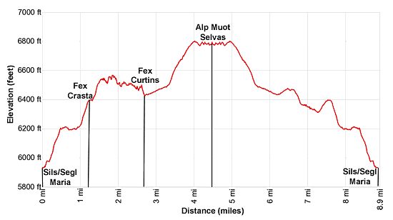
Cumulative elevation gain and loss for the hike to Alp Muot Selvas: 1,200-ft. (366-meters)
Note: Piz in Romansh, a language spoken by some in the Swiss Engadine, means peak and lej, leg and lai means lake. (Piz Lagrev is Lagrev Peak and Lej Segl is Lake Segl, or in German: Silsersee.) Trail signs will often have two different names (one in Romansh and one in German) or different spellings for a destination. For example, Sils: German and Segl: Romansh.
Find the Val Fex trailhead, located across from Chesa Cumunela (the City Hall), a short distance to the southwest of the Sils/Segl Maria Post. (See directions to the trailhead below.) Here signs for the Schluchtweg (Gorge Path) list the times to destinations in the valley including Val Fex Platta (30 min), Val Fex Crasta (50 min), Val Fex Curtins (1 ½ hrs) and Muot Selvas (2 hrs) near the head of the valley.
Follow the path as it heads southwest through meadows and then enters the trees, ascending on easy grades along the left side of a pretty gorge channeling the Fedacla, the stream draining Val Fex. As the path climbs out of the gorge trees give way to lovely meadows sprinkle with wildflowers. Here views open Piz Lagrev and nearby peaks towering above the northwest side of the Upper Engadine Valley. After 0.5 miles (0.8 km) the grade abates as the path joins a road, curves to the south/southeast and then passes the junction with a trail branching left toward Vanchera and Marmore.
Our trail now heads south along the narrow road, passing houses along with a hotel/restaurant in Fex Platta at 0.75-mi (1.2 km) (30 min). Ahead views open to Il Chaputschin and Piz Tremoggia rimming the southeast side of the cirque at the head of Val Fex.
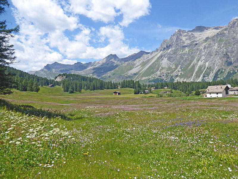
At 0.9 miles (1.5 km) stay on the road as it curves to the right and crosses a bridge over the Fedacla. On the west side of the bridge take the path, signed for Fex Cresta amd Fex Curtins, which swings to the left (south) and climbs on moderate grades through scenic meadows with lovely views of the peaks rising above the Upper Engadine. Soon the path reaches the valley’s main road where the grade abates. Here signs direct hikers left (south/southeast) along the road to Fex Crasta (6,400-ft./1,951-meters/50 min) at 1.25 miles (2.0 km). A photogenic chapel, adorn with frescoes dating back to 1511, and the Hotel Sonne mark the center of this tiny village. This is a good turn around point for hikers looking for a short, easy day.
Continue past the hotel, ignoring the roading going right to Maloja. At 1.3 miles (2.1 km) reach a junction. Here hikers have a choice of staying on the road to Fex-Curtains or taking the trail branching right toward Fex-Curtins and Muotta Ota. The road has better views but is shared by electric bikes and horse carts. I prefer taking the trail up and then returning via the road.
Bear right on the trail that briefly ascends and then follows an undulating course through larches and small meadows along the west side of the valley. Openings offer pretty views of the valley and the peaks rising to the southeast.
At 1.6 miles (2.6 km) pass a junction with a trail branching right toward Maloja and then a second junction at 2.1 miles (3.4 km) with the trail forking right to Muott Ota. (The trail to Muott Ota, a minor summit atop the ridge rimming the west side of the valley, gains over 1,000-ft (300-meters) as it climbs to the ridge crest with panoramic views of the upper Engadine.) We continue straight ahead toward Fex Curtins.
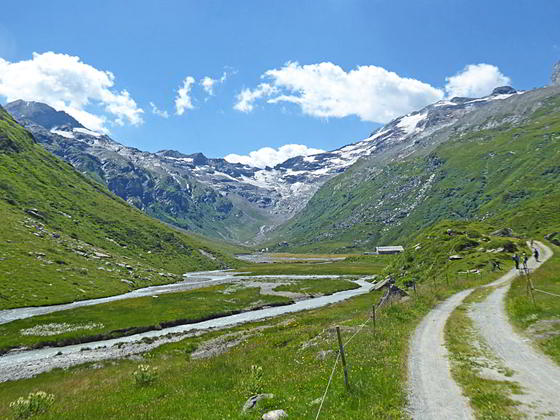
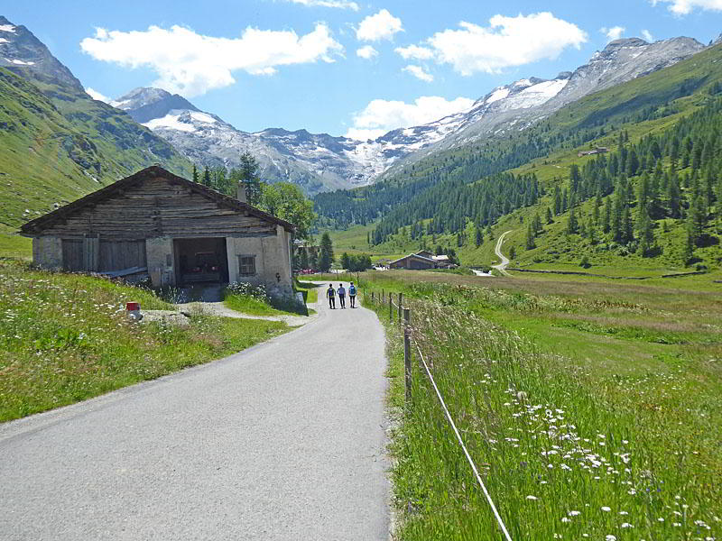
Soon the trail descends on easy grades to the valley floor where it goes over a bridge spanning the Fedacla and then crosses a farm yard to rejoin the main road heading up the east side of the valley at 2.7 miles (4.3km). Behind you are fine views of Fex-Curtins, the Hotel Fex and the peaks rising above the north side of the Upper Engadine. Ahead the beautiful cirque towering above the head of the valley, anchored by Piz Tremoggia and Piz Fora, fills the skyline. This is another good turnaround point for parties looking for a shorter day.
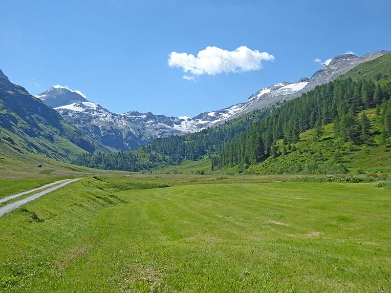
Turn right and follow the road as it ascends on easy grades through verdant meadows, accompanied by lovely views up and down the valley. At 3.25 miles (5.2 km) cross a bridge over the Fedacla to the west side of the valley. Here the path climbs on moderate grades up the valley’s western slopes to join a gravel track at 3.6 miles (5.8 km). Across the valley waterfalls spills down meadow-clad slopes.
The track continues its ascent, now high above the river. At 4.0 miles (6.4 km) the grade abates as the track crests a rise where great views reopen to the rugged cirque, adorn by the remains of three glaciers, at the head of the valley. A gentle descent now leads to restaurant at Alp Muot Selvas, situated at the foot of the glacial basin, at 4.4 miles (7.1 km). The gorgeous basin is surrounded by glacier-clad peaks including Il Chaputschin, Piz Gluschaint, Piz Tremoggia, Pix Flora and Piz Fedoz. Waterfalls tumble down rugged rock slopes and emerald green meadows to a rocky glacial basin. Cow graze amid the meadows.
On a beautiful day the restaurant is a busy place. Hikers looking for a nice picnic spot should cross the metal bridge over the nascent Fedacla to the east side of the valley and then find a nice perch in the rocky meadows to relax and take in the views. Alternatively, you can wander further up the west side of the valley on boot beaten paths.
When you are ready to head back retrace your steps to the junction with the trail heading toward Muott Ota. If you wish to return by the road, do not take this path but instead stay on the main road down the valley, enjoying the fabulous views up and down the valley. Along the way you will go through the center of Fex-Curtins, home to beautifully restored stone barns/houses.
Reach the trailhead at the southwest end of Sils/Segl Maria at 8.9 miles (14.3 km). Turn right to return to the Sils/Segl Maria Post where you can catch a bus back to your accommodations.
Elevation Profile
Driving Directions
From the St. Moritz Bahnhof (train station) to Sils/Segl Maria, Posta: At the St. Moritz Train Station board a #4 bus heading toward Chiavenna or Maloja Post or the #5 bus to Sils/Segl Maria Post and get off at the Sils/Segl Maria Post stop.
From the bus stop walk south (in the direction the bus is traveling) along the main street, Via de Marias, for 700-ft. (220-meters) to an intersection. (The Chesa Cumunela (the City Hall) is located across the street.) Continue a short distance beyond the intersection on Via da Fex to trail signs marking the start of the Val Fex trail on the left (south) side of the street.
Get information from the local tourist office, visit the Engadine Bus Routes page, go to SBB website or download the SBB app to find the routes, schedules and stop nearest your accommodations. Note that some of the bus route may require you to change buses at Silvaplana, Kreisel Mitte (Stand A) to get to Sils/Segl Maria Post.
Trail Resources
- Trail Photo Gallery
- Trail Maps
- Basecamp(s) Information: St Moritz
- Region Information: Eastern Switzerland
- Other Hiking Regions in: Switzerland