Details: Gruben to Jungen via Augstbord Pass 
Distance: 8.2 miles (one way)
near Gruben in The Valais
By: Diane Greer
Hike Facts
- Distance: 8.2 miles (one way)
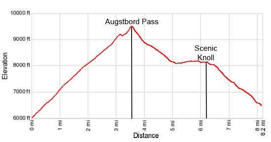
- Elevation: 5,988-ft. - 9,495-ft.
- Elevation Gain: 3,507-ft.
- Difficulty: strenuous
- Trail Highlights: See Trail Intro
- Basecamp(s): Gruben / Zermatt
- Region: The Valais
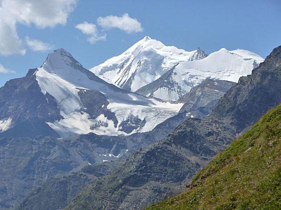
One of my favorite hikes in the Valais is the steep, scenic climb over Augstbord Pass leading to an overlook with stunning, panoramic views of the Bernese Alps and the high peaks towering above the Mattertal from Stalden to Zermatt.
Gruben to Augstbord Pass
Distance from Trailhead: 3.6 miles (one way)
Ending/Highest Elevation: 9,495-ft.
Elevation Gain: 3,507-ft.
At the trailhead, starting behind (south side) of the Schwarzhorn Hotel in Gruben (5,988-ft.), signs point east toward Augstbordpass (3-hr) and St Niklaus (6-hr 40-min). The trail ascends steeply up a broad grassy track, crossing a wood bridge over a stream at 0.2 miles.
Beyond the stream a series of steep switchbacks climb through larch and pine forest. Openings in the trees offer views across the valley to the Meidhorn and the ridge running along the west side of the Turtmanntal (Turtmann Valley). As you ascend, the trees give way to shrub filled meadows with views of the Bernese Alps rising to the north of the Rhone Valley.
Reach a trail junction with a track going left (north) for Chanzibodu. Continue straight ahead following the signs for Augstbordpass (2-hr 10-min), Jungen (4-hr 50-min) and St Niklaus (6-hr 10-min). As the trail gains altitude views open to Les Diablons, towering above the head of the Turtmanntal, and Meidpass (Meid Pass) across the valley.
At 1.4 miles arrive at the junction (7,448-ft.) with the trail branching right (south) to the Turtmannhutte (Turtmann Hut 2-hr 55-min). Bear left on the main trail to Augstbordpass (2-hr). To the north are distant views of Altels and the Balmhorn rising above the head of the Leukerbad Valley.
The trail continues its ascent up steep switchbacks and then crosses a rocky meadow, passing a few old stone buildings. At 1.7 miles reach a second junction (8,907-ft.) with a trail branching right (south) toward the Turtmannhutte (2-hr 40-min). Our trail proceeds straight ahead, ascending through meadows along the left (north) side of the Gruobutalli Valley and a small creek.
At 2.0 miles the trail curves to the right, crosses the creek and then climbs a low knoll, hoping over a stream along the way. From the top of the knoll enjoy great views of Meidpass and the peaks rising along the west side of the Turtmanntal. Rugged slopes with talus aprons line the south side of the Gruobutalli valley.
Re-cross the stream at 2.4 miles and then ascend steeply up rocky meadows along the north side of the valley to the base of a bluff. A rocky trail now ascends the west face of the bluff on very tight, steep switchbacks. Use care if there is ice or snow on the trail.
Reach the top of the bluff at 3.1 miles. Ahead you will see Augstbord Pass, the low saddle on the ridge. Turn around for great views across the Turtmann Valley to the west. Below the trail, to the south, meltwater flows down a rocky gorge.
The trail now ascends grassy meadows atop the bluff. At 3.2 miles follow the trail as it drops into a bowl and curves around the right (south) side of a small tarn nestled beneath the pass. At the east end of the tarn the trail turns left (northeast) and ascends on a diagonal across a boulder field. Rock cairns mark the route. If the boulder field is snow covered, aim for the grassy slopes below the pass.
Beyond the boulder field the trail reaches a grassy slope and turns right (east), climbing steep switchbacks to Augstbord Pass (9,495-ft.) at 3.6 miles. Here distant views extend east toward the peaks towering over the Saastal (Saas Valley) including the Boshorn, Senggchuppa and the Fletschhorn. The Schwarzhorn (10,501-ft.) rises to the north of the pass. The peaks and ridges rising above the Turtmanntal fill the skyline to the west.
(Note: The best views of this hike are not at the pass but atop a grassy knoll overlooking the Mattertal (Matter Valley) at 6.3 miles. I recommend taking a short rest stop at the pass and saving your lunch break for the Mattertal viewpoint.)
Augstbord to Jungen
Distance from Trailhead: 8.2 miles (one way)
Ending/Highest Elevation: 6,562-ft.
Elevation Gain: -2,933-ft.
To continue to Jungen (2-hr 45-min) and St Niklaus, follow the trail as it descends from the pass on steep, scree-covered slopes beneath the south facing slopes of the Schwarzhorn. After walking a half mile the grade moderates as the path wanders through boulder-strewn meadows, crossing a few rockslides along the way.
Soon the trail curves to the right (south) and passes through a narrow gap in the rocks at 4.5 miles (0.9 miles from the pass). Beyond the gap the grade steepens as the trail curves to the left, descending through rocky meadows along the north side of the valley.
Reach a “Y” intersection at 4.7 miles where signs point left (northeast) to Embd and Moosealp. Take the trail branching right (east) for Jungen and St Niklaus. (The transportation links from Jungen to either Grachen or Zermatt are more frequent than the buses from Embd and Moosealp.)
The trail soon turns to the right (south), descending to cross a gully to the south side of the valley. Here the path begins to ascend on easy to moderate grades, heading southeast on a well-laid path through a long boulder field.
Reach the top of the boulder field at 5.9 miles. Turn around for nice views of Augstbord Pass to the west. Continue climbing for a short distance to a small shoulder jutting from the ridge at 6.0 miles. Here marvelous views open to the confluence of the Matter and Saas valleys and the surrounding peaks.
Beyond the shoulder the narrow trail clings to the hillside, following a roller coaster course through rocky meadows. There is a feeling of exposure along this section of the route, which may make some members of your party uncomfortable.
Reach a grassy knoll with stunning, panoramic vistas at 6.3 miles. The knoll is a great place for a picnic or to take a break while admiring the views. The Bernese Alps fill the skyline to the north. The peaks of the Mischabel range, including the Nadelhorn, Lenzspitze and the Dom, rise above the east side of the Mattertal while the Weisshorn, Bishorn and Brunegghorn dominate to view to the southwest. Monte Rosa, Lyskamm and the Breithorn tower above the head of the Mattertal valley to the south. In the distance are the peaks flanking the east side of the Saas Valley.
Continue the hike by following the trail as it descends southeast on moderate grades. Turn left toward Jungen at a signed junction at 6.5 miles and follow the trail as it drops steeply down a series of switchbacks through meadows and clusters of larch trees.
Reach a somewhat confusing intersection at 7.0 miles. Here signs point straight ahead toward Juntal. We turn left on the unmarked trail that heads downhill on switchbacks toward Jungen. (Don’t take the trail toward Juntal.) At the next signed junction turn right toward Jungen (Jungu 35-min and St. Niklaus). The rest of the way Jungen (Jungu) is on a good, well-marked trail.
At Jungen (6,562-ft.) follow the signed path toward the Luftseilbahn (10-min) passing a small lake along the way. Reach the small cable car descending to St Niklaus at 8.2 miles. You can either take the lift from Jungen to St. Niklaus or walk down to St. Niklaus on a series of very steep, knee-jarring switchbacks. The lift is the recommended option. Note: The 4 person lift takes an extended lunch break. Do not be disheartened if a large group of people are waiting for the lift. Once started, the lift runs continuously until everyone is down.
While the trail between Gruben and Jungen is quite steep, is not overly difficult thanks to well-engineered switchbacks facilitating the climb to the pass. There is no place for refreshments along the way, so pack a lunch and take plenty of water.
This trail can easily be walked in reverse. Frequent trains run between Zermatt and St. Niklaus. At St. Niklaus catch the cable car to Jungen. (See the Jungen Luftseilbahn (Jungen cable car) schedule for more information.) Hikers staying in Grachen can take the bus from Grachen to the St. Niklaus Bahnhof (train station) and then the lift to Jungen. In Jungen, follow the trail signs to Augstbord Pass.
Check the weather forecast before setting out from Gruben. Sections of the trail are very difficult to follow in thick fog and the high exposed slopes should be avoided during thunderstorms.
Elevation Profile
Driving Directions
Directions from the Hotel Schwarzhorn in Gruben: This trail starts behind (south side) of the Schwarzhorn Hotel in Gruben
From Zermatt to Jungen: If walking the trail in reverse, take the train from Zermatt to St. Niklaus. In the height of the summer trains depart every half hour. The ride takes about 35 minutes. In St. Niklaus, walk to the southwest end of the train stations (in the direction of Zermatt) and turn right (west) on the first street beyond the train station, which drops down to an underpass beneath the main Visp-Zermatt highway. On the other side of the underpass turn right (northeast) and walk up the road to the Jungen Cable Car station (the Jungen Luftseilbahn).
Trail Resources
Trail Intro / Trail Photo Gallery / Trail Map
Basecamp(s) Information:
Gruben / Zermatt
Region Information:
The Valais
Other Hiking Regions in:
Switzerland