Details: Antrona Pass via Heidbodme 
Distance: 10.4 miles (round trip)
near Saas Fee in The Valais
By: Diane Greer
Hike Facts
- Distance: 10.4 miles (round trip)
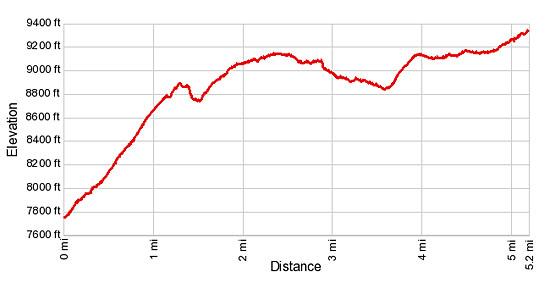
- Elevation: 7,685-ft. - 9,311-ft.
- Elevation Gain: 2,126-ft.
- Difficulty: strenuous
- Trail Highlights: See Trail Intro
- Basecamp(s): Saas Fee
- Region: The Valais
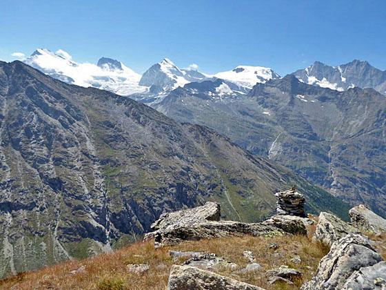
This trail starts at the scenic overlook at Heidbodme, with panoramic views of the peaks towering above the Saastal. The path then travels on a high route along the eastern slopes of the Furgg Valley to Antrona Pass, a remote and wild saddle on the Swiss-Italian border.
Heidbodme to Antrona Pass
Take the bus to Saas Almagell Dorftplatz and then the two stage chairlift to Heidbodme. (See the trailhead directions below.) Before starting the hike, take some time at Heidbodme (7,698-ft.) to enjoy the wonderful views of the peaks rising along the west side of the Saastal (Saas Valley). Notable peaks include the Strahlhorn and Rimpfischhorn towering to the west of the Mattmark area and the peaks forming the cirque around Saas Fee, the Allalinhorn, Alphubel, Taschhorn, Dom and Lenzspitze. Directly across the valley are the Mittaghorn and Egginer rising to the south of the Plattjen area.
From the top of the Heidbodme chairlift walk east toward Antrona Pass. Soon the trail starts climbing a series of steep switchbacks along the south facing slopes of the Almagellerhorn. At the 1.0 mile mark, ignore the trail branching left to the Panoramaplatz (panoramic viewpoint). Continue climbing toward Ougschtchumme (40-min) and Antrona Pass (2-hr 40-min).
At 1.3 miles the trail drops steeply for a short distance to cross a gully then resumes its steep climb, reaching Ougschtchumme (8,967-ft.) at 1.9 miles. Ougschtchumme enjoys wonderful views of the Nollenhorn and Stellihorn towering over the southwest side of the Furggtal (Furgg Valley). The low saddle at the head of the valley is Antrona Pass. The peaks rising along the Saas Fee and the upper Saas Valley fill the skyline to the west/southwest.
Past the viewpoint the grade eases as the trail crosses an avalanche chute, curves around a crag and then traverses the steep slopes beneath the Sonnighorn. At 2.9 miles reach the signpost for Beerterrigg (9,186-ft.). A short distance beyond the sign the trail descends a flight of steep log steps and then continues its descent, on easy to moderate grades, through rocky meadows.
At 3.6 miles the trail curves around a ridge and then climbs a hillside on moderately steep grades, crossing a few rock slides along the way. At 3.9 miles the grade abates and the path now ascends on easy to moderate grades.
Soon the meadows give way to rocky slopes sprinkled with small tufts of grass. Red and white blazed rocks and occasional metal posts mark the trail. Along the way the trail crosses a few streams and travels through moist areas of flattened rocks interspersed with mounds of moss.
At 4.7 miles the path starts climbing on moderate grades up a rocky hillside, weaving its way up and around large rock slabs. Red/white blazes will keep you on track. The markings can be hard to follow, especially if portions of the trail are covered in snow. If this is the case, follow the footsteps in the snow or plot your own course to the ridge.
At 5.1 miles pass a large boulder with an arrow point left toward Furggu (Furggstalden) and right toward Heidbodme. A final short climb up rocky slopes brings you to Antrona Pass (9,311-ft.), on the Swiss/Italian border, at 5.2 miles. The pass enjoys nice views of the peaks rimming east side of the valley and the Stellihorn to the west. To the southeast is Italy where views extend to the peaks forming the southern wall of the Troncone Valley. Looking down you will see the Lago del Cingino (Lake Cingino).
From the pass a trail descends toward Antronapiana in Italy, a multi-day excursion. The trail to Jazzilucke (Jazzilicke) climbs south/southwest along the ridge on a challenging route that leads to the Mattmark area. For more information see the Mattmark to Antrona via the Jazzilucke hike description.
When you are done enjoying the views retrace your steps to the Heidbodme lift for a 10.4 mile round trip hike. Alternatively, take the trail to Furggstalden which drops to the valley floor and then descends through pretty meadows, losing over 3,000-ft in 5.2 miles for a 10.4 mile hike.
If you are tired and/or pressed for time the route to Furggstalden is the best bet. For more information see the Antrona Pass via Furggstalden hiking description. If you have the time and energy then return via Heidbodme, which has the best views.
Elevation Profile
Driving Directions
From Saas Fee to Heidbodme: Obtain a bus ticket from Saas Fee to Saas Almagell Dorfplatz. In Saas Fee take the bus heading toward Brig. Change at Saas Grund for the bus going to Mattmark or Saas Almagell Sportsplatz (south up the valley). Get off the bus at the Saas Almagell Dorfplatz. Follow the signs to the Furggstalden Sesselbahn (chair lift). Make note of the time when the last ride descends to the valley.
At the top of the Furggstalden lift find the trail heading southwest to the bottom of the Heidbodme Sesselbahn (chair lift). The 0.25 miles walk loses about 200-ft. At Heidbodme purchase a ticket and take the lift to the top station.
Note: Purchasing round-trip tickets for lifts is typically cheaper than purchasing two one-way tickets. For more information on the chairlifts see the Saas Fee Lift Schedule and look at the section labeled Saas-Almagell.
Return directions from Heidbodme (Saas Almagell) to Saas Fee: At Heidbodme, purchase a ticket for the two stage lift to Saas Almagell. Take the Heidbodme Sesselbahn (chair lift) and then walk northeast, following the signs to the Furggstalden Sesselbahn (chair left) in Furggstalden. The walk is a little over a quarter mile. Take the Furggstalden lift down to Saas Almagell and then follow the signs to the postbus stop.
Get on a bus bound for either Saas Fee or Saas Grund. If you are on a Saas Grund bus, change at Saas Grund for a bus going to Saas Fee. (During busy times in the summer extra buses are run that do not follow the typical routes. Always check the front of the bus to see its ultimate destination.)
For more information on the chairlifts see the Saas Fee Lift Schedule and look at the section labeled Saas-Almagell.
Trail Resources
Trail Intro / Trail Photo Gallery / Trail Map
Basecamp(s) Information:
Saas Fee
Region Information:
The Valais
Other Hiking Regions in:
Switzerland