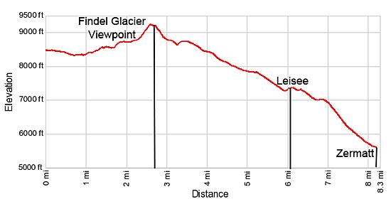
Details: Findel Glacier Viewpoint 
Distance: 5.4 - 8.3 miles (round trip)
near Zermatt in The Valais
By: Diane Greer
Hike Facts
- Distance: 5.4 - 8.3 miles (round trip)
- Elevation: 8,457-ft. - 9,217-ft.
- Elevation Gain: 892-ft.
- Difficulty: easy-moderate
- Trail Highlights: See Trail Intro
- Basecamp(s): Zermatt
- Region: The Valais
This moderately-easy trail leads to a peaceful overlook with wonderful views of the Findel Glacier flowing down the slopes of the Cima di Jazzi. Along the way hikers enjoy splendid views of the Matterhorn.
Findel Glacier Viewpoint
Distance from Trailhead: 2.7 miles (one way)
Ending/Highest Elevation: 9,217-ft.
Elevation Gain: 892-ft.
The day starts by taking the funicular to Sunnegga, a popular overlook with panoramic views of the Matterhorn, and then riding the gondola to Blauherd (8,435-ft.). (See trailhead directions below.)
At Blauherd enjoy great views of the Matterhorn to the southwest. Across the valley to the west a massive wall of 4,000-meter peaks, including the Ober Gabelhorn massif, the Wellenkuppe, the Zinalrothorn and the Weisshorn, fill the skyline. To the south the top of the Breithorn massif rises above the Gornergrat ridge.
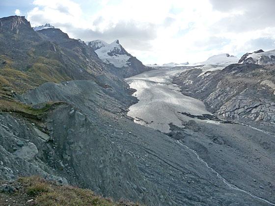
After taking in the views find the trail signpost and head southeast on the broad track toward the Stellisee and Fluealp. After walking about 0.1 miles watch for a trail branching left and climbing above the road. Follow the trail as it descends on gentle grades to the Stellisee. Soon nice views open east to the Findel Glacier pouring down the slopes of the Cima di Jazzi (12,477-ft.) between the Strahlhorn and Rimpfishhorn, to the north, and the Stockhorn, to the south.
Reach the west end of the Stellisee at 0.7 miles. The small lake is famous with photographers for its wonderful views of the Matterhorn perfectly reflected on the lake’s clear waters. After enjoying the views from the lake, walk around the south side of the lake to a dirt track. Turn left (east) on a track ascending on easy grades toward Flue and Fluhalp.
At 1.1 miles a trail, marked by a wood sign leaning against a rock, branches left from the road toward Fluealp. You can either stay on the road or take this trail through meadows and an old rock slide. (I personally prefer the trail.) In the distance you will see the Berghaus at Fluhalp.
Ascend through rocky meadow on moderate grades toward the Berghaus. Be sure to turn around for nice views of the Matterhorn and the Ober Gabelhorn massif rising above the Hohbalm plateau.
Cross a broad track descending from the Oberrothorn at 1.3 miles and arrive at the Berghaus Fluhalp (lodging and refreshments), at 1.4 miles. Follow the trail as it curves around the west side of the Berghaus to regain the track.
Turn left (east) and walk along the track for a short distance to an intersection. Here the road turns north toward the hotel. Bear right (south/southeast) on a trail that descends gently across rocky meadows toward the north moraine wall of the Findel Glacier. At 1.6 miles the trail reaches a path, which I call the Findel Viewpoint trail, paralleling the base of the wall. Turn left on the Findel Viewpoint trail and follow the path as it ascends east/northeast through lovely meadows between the grassy slopes of the moraine wall and the rugged cliffs of the Oberrothorn massif.
At 1.75 miles a use/social trail climbs to the top of the moraine wall, revealing the huge river of ice flowing down the flanks of the Cima de Jazzi, a snow-clad flat-topped peak on the Swiss–Italian border. The Adlerhorn and Strahlhorn tower above the glacier to the north.
The use trail now travels along the top of the moraine for 0.3 miles. Hikers uncomfortable walking on the moraine crest should drop back down to the Viewpoint trail and continue ascending northeast through the meadows. (Note: The condition of the moraine wall changes every year. Use your judgment and descend when the crest becomes too eroded and dangerous to follow.)
At 2.1 miles reach a section of the moraine wall that has collapsed, forcing the use/social trail to descend to the meadows and the Viewpoint Trail. The Viewpoint trail now ascends on easy grades up the slopes to the north of the moraine, passing two small ponds. Just beyond the second pond the the trail climbs steeply up the hillside to a grassy knoll at 2.7 miles. Leave the trail here and walk to the edge of the knoll where marvelous views open to the Findel Glacier, a vast sea of ice pouring down the valley. The overlook features bird’s-eye view of the deep trench carved by the glacier and the knife edge wall of the moraine. In the distance, the majestic Matterhorn towers above the Zermatt valley.
On a sunny day this is a great spot for a picnic. Not very many people hike this far up the valley, so you are likely to have a level of solitude not found at many of the viewpoints around Zermatt area.
(Note: The trail continues climbing and soon becomes a route that crosses a rugged saddle between the Spitzi Flue and the Pfulwe. Beyond the saddle a route descends to Tasch.)
Back to Blauherd, Sunnegga or Zermatt
Distance from Trailhead: 8.3 miles (round trip)
Ending/Highest Elevation: 5,490-ft.
Elevation Gain: -3,727-ft.
When you are ready to head back, either retrace your steps to Blauherd, walk back to Sunnegga or hike all the way down to Zermatt. If time, energy and the weather permit, I recommend walking back to Zermatt.
To walk back to Sunnegga or Zermatt, descend the steep hillside to the use/social trail climbing atop the moraine. Here you have a choice. Either continue on the trail traveling through meadows beside the moraine, passing the turnoff to the Berghaus, or climb back atop the moraine. If you climb the moraine you should be able to continue along the use/social trail for 0.6 miles before you are again forced to climb down to the meadow (Viewpoint) trail at 4.0 miles (1.3 miles from the knoll).
In the meadows continue along the Viewpoint trail as it head west, descending on moderate grades toward the Leisee, Winkelmatten and Zermatt. Ignore any trails branching right or left. At 5.9 miles the grade abates as it approaches the Leisee (7,320-ft.), a small lake just below Sunnegga. The lake, at 6.1 miles, is a popular spot with families and features a playground and barbeque area along with stunning views of the Matterhorn.
From the lake a trail climbs a short distance to Sunnegga where you can take the funicular back to Zermatt. Total hiking distance for this option is 6.3 miles.
Alternatively a number of walking paths descend steeply through meadows and larch forests to Winkelmatten, a neighborhood at the south end of Zermatt, losing over 1,800-ft. in 2.2 miles, for an 8.3 mile hike. If you are interested in stopping for refreshments on the hike down, take the path back to Zermatt that pass through Eggen and Findeln. Restaurants in both village feature sun terraces with pretty views of the Matterhorn.
Elevation Profile
Driving Directions
Walking from the Zermatt Bahnhof (train station) to the Sunnegga Funicular: Directly across from the Zermatt train station is the station for the Gornergrat Cog Railway. The first street to the south of the Gornergrat Station is Getwingstrasse (Getwing Street), which runs east. Find Getwingstrasse and walk east along the street for 0.2 miles (300-meters). The street will curve to the southeast and cross the Vispa River.
On the other side of the river turn left (east/northeast) on Vispastrasse (also labeled as Rechte Uferstrasse on some maps). Walk about 0.1 miles, following the street as it curves to the north/northeast. The Sunnegga Funicular Station is on the right side of the road at Vispastrasse 34.
After obtaining funicular tickets, walk through a long underground tunnel to get to the base of the funicular. The schedule for the funicular is found on the Matterhorn Paradise time table page. Select the Sunnegga – Rothorn option.
Upon arriving at Sunnegga, enjoy the views of the Matterhorn and then follow the signs to the Blauherd Gondola that ascends over 940-ft. to the start of the hike. You can hike from Sunnegga to Blauherd. At Sunnegga, signs point to a trail ascending on very steep grades through meadows directly under or near the Blauherd gondola lines.
Note: Round-trip tickets are available for a variety of ride combinations at the funicular station. For example you can purchase tickets from Zermatt to Blauherd going up and from Sunnegga to Zermatt going down.
Trail Resources
Trail Intro / Trail Photo Gallery / Trail Map
Basecamp(s) Information:
Zermatt
Region Information:
The Valais
Other Hiking Regions in:
Switzerland