Hike Facts
- Distance: 7.0 - 8.5 miles (loop)
- Elevation: 7,134-ft. - 10,138-ft.
- Elevation Gain: 3,004-ft.
- Difficulty: moderate-strenuous
- Trail Highlights: See Trail Intro
- Basecamp(s): Zermatt
- Region: The Valais
Great views accompany almost every step of this hike leading to Gornergrat, a glorious overlook with panoramic views of 20 peaks over 13,000-ft. (4,000-meters) high.
To Gornergrat
Distance from Trailhead: 4.4 miles (one way)
Ending/Highest Elevation: 10,138-ft.
Elevation Gain: 3,004-ft.
The 15 minute train ride from Zermatt to the Riffelalp Train Station ascends along the east side of Zermatt, crosses a bridge with views of a waterfall above Winkelmatten and then switchbacks up forested hillsides to Riffelalp, with some nice views of the Matterhorn along the way.
At the Riffelalp Train Station (7,254-ft.) look for signs on the west side of the building pointing toward a broad trail heading west to Riffelalp (10-min), Riffelberg (1-hr 10-min), Rotenboden (2-hr) and Gornergrat (2-hr 50-min). The trail curves to the southwest on easy grades, paralleling a small cog railway transporting luggage and people to the Riffelalp Hotel. Arrive at the Riffelalp Hotel and Restaurant in 0.25 miles.
Continue along the broad track through the hotel complex, enjoying beautiful views of the Matterhorn’s east and north faces. At 0.3 miles reach a junction with signs pointing right (southwest) to the road that drops to Winkelmatten and Zermatt and left (southeast) toward a trail heading to Gagenhaupt, Rotenboden, Gornergrat, Gletschergarten and Furi. Turn left and walk along the trail for 0.2 miles, passing a tennis court and chapel, to a second junction where the trail to Furi and the Gletschergarten continues straight ahead. Bear left (south) on the path toward Gagenhaupt, Rotenboden and Gornergrat.
Follow the trail as it curves to the southwest on easy grades and soon starts ascending steep slopes clad in rocky meadows and scattered larches beneath the Riffelberg plateau. Occasional switchbacks facilitate the moderately-steep climb. Along the way enjoy great views of the Matterhorn towering above the Matterhorn Plateau. A massive wall of 4,000-meter peaks, including Dent Blanche, the Ober Gabelhorn massif, the Zinalrothorn and the Weisshorn, fill the skyline to the northwest while the Taschhorn and the Dom form a backdrop for the Oberrothorn to the northeast. As the trail gains altitude hikers are treated to bird’s-eye views of Riffelalp and Zermatt. In the distance, to the north, are the peaks rising above the Rhone Valley.
At 1.3 miles the grade eases as the trail curves to the south and soon reaches a junction with a trail branching right (southwest) toward the Gletschergarten, Furi and Zermatt. Another trail takes off uphill to the northeast toward Riffelberg. Our path continues straight ahead to Gagenhaupt, Rotenboden and Gornergrat.
The path now veers to the southeast, climbing on moderate grades through pretty meadows. Views open to the Klein Matterhorn and the Breithorn massif. The pyramid-shaped Matterhorn is particularly lovely from this angle.
At 1.9 miles the trail curves to the east and ascends a shallow valley formed by the Riffelhorn’s eastern ridge and the Riffelberg plateau (to the north). The Riffelhorn (9,603-ft.), a small, triangular-shaped peak rising to the south of the Riffelberg plateau, is a favorite place for climbers to train before tackling the big peaks.
Arrive at Gagenhaupt (8,412-ft.) at 2.0 miles. Here a trail branches to the left (northwest) toward Riffelberg. We continue straight ahead, climbing the small valley toward the Riffelsee, Rotenboden and Gornergrat. As you ascend turn around for nice views of the Matterhorn, Dent Blanche, the Ober Gabelhorn massif and Wellenkuppe.
More signposts are passed at 2.3 and 2.5 miles. As before, ignore the trails to the left toward Riffelberg and continue straight ahead toward the Riffelsee and Rotenboden. After the second signpost the grade abates as the trail approaches a small tarn and then reaches the Riffelsee, a small alpine lake cradled beneath the Riffelhorn, at 2.7 miles. On calm mornings the tarn and the popular lake are a photographer’s delight, with the Matterhorn perfectly reflected in the still waters.
Beyond the Riffelsee the trail climbs toward Rotenboden. Wonderful views open to the snow-covered summits of the Monte Rosa, Liskamm and the Breithorn. Glaciers cascade down the flanks of the peaks.
Reach the turnoff to the Rotenboden Train Station on the Gornergrat line at 3.0 miles. To the left (north) is a trail ascending to the railway. To the right (south) a trail drops down to the Gornergletscher (Gorner Glacier) viewpoint and the route to Monte Rosa Hut. Continue straight ahead toward Gornergrat.
The trail now climbs steeply up a rocky hillside beside the Gornergrat Railway. Marvelous views of Monte Rosa, Liskamm, Castor, Pollux and the Breithorn, along with the glaciers spilling down the mountains, will help take you mind off the steep ascent. Behind you are glorious views of the Matterhorn. It is unfortunate that the railway is so close to this section of the trail but you will likely to be riveted to the views of the mountains and glaciers to the south, ignoring the presence of the tracks and the occasional passing train.
At 3.7 miles the grade eases as the trail contours around a small bowl. Here views open north to the Taschhorn, Dom, Rimpfischhorn and Strahlhorn in the Mischabel Range. In the distance are the peaks rising above the Rhone Valley.
Beyond the bowl, the trail makes its final short, steep ascent to the Gornergrat rail station and hotel complex at 4.3 miles. The complex, set atop the Gornergrat summit (10,138-ft.), is located along a ridge separating the Findel and Gorner Glaciers. The complex includes a hotel, restaurants and observatories (not open to the public).
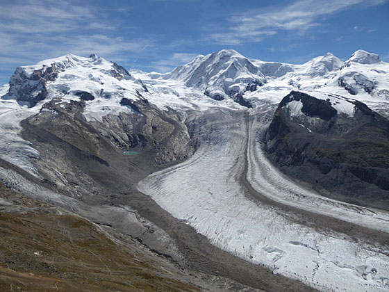
Ascend a short distance behind the complex to an overlook, at 4.4 miles, for the best views. Here a stunning 360-degree panorama encompasses 20 peaks over 13,000-ft. (4,000-meters) high. To the south are breathtaking views of Monte Rosa, Liskamm, Castor, Pollux and the Breithorn, covered in snow and ice. The Monte Rosa, Grenz, Zwillings and Schwarzee glaciers pour off the flanks of the peaks and down the valleys to combine with the Gorner Glacier, flowing to the north of Monte Rosa, to form the second largest glacial system in the Alps.
Dominating the skyline to the west is the majestic Matterhorn. To the northwest are glorious views of Dent Blanche, the Ober Gabelhorn massif, the Zinalrothorn and the Weisshorn towering above the Zermatt valley. To the northeast, the distinctive jagged peaks of the Mischabel Range rise beyond the Oberrothorn.
On a nice day it is delightful to sit in the sun on the benches around the overlook and soak in the scene. Be sure to take warm clothes. It can get quite windy at the viewpoint.
Back to Riffelalp via Riffelberg
Distance from Trailhead: 8.5 miles (loop)
Ending/Highest Elevation: 7,134-ft.
Elevation Gain: -3,004-ft.
When you finally pull yourself away from the Gornergrat Viewpoint, retrace your steps back to Rotenboden junction (5.8 miles), the Riffelsee and the tarn to a sign post at 6.3 miles. Turn right (north) and head toward Riffelberg.
The trail now descends on moderately-steep grades across the rocky meadows of the Riffelberg plateau, accompanied by lovely views of the peaks surrounding the Zermatt valley. Reach Riffelberg (8,471-ft.) at 7.0 miles. Here you can either catch the train back to Zermatt or continue walking to Riffelalp.
To continue to Riffelalp, find the sign post near the train station pointing left (west) toward Riffelalp, Winkelmatten and Zermatt. Walk west, curving around the south side of the Hotel Restaurant Riffelberg (pink Victorian building with red shutters). Here a trail drops steeply down the grassy slopes forming the west wall of the Riffelberg plateau.
The descent, facilitated by switchbacks, offers bird’s-eye views of Riffelalp and Zermatt. Initially the trail heads west but soon swings around to the north/northwest as it drops down the steep slopes. Near the bottom of the descent the path crosses a small stream, turns to the west and then meets a dirt road above Riffelalp.
Travel down the dirt road for a short distance to a signpost. To the left (southwest) is the road descending to Winkelmatten and Zermatt. We turn right (northeast), walk by the Riffelalp Hotel and Restaurant (8.25 miles) and then continue along the broad track that leads back to the train station at 8.5 miles.
Hop on the next train to Zermatt or cross the tracks and take the trail, which drops down through larch and pine trees, to Winkelmatten in 2.2 miles for a total round-trip hiking distance of 10.7 miles. Add 0.6 miles if walking to the Zermatt Bahnhof. (See the trailhead directions below for information on walking to Winkelmatten and Zermatt.)
Shorter Hikes to/from Gornergrat
The Gornergrat hike can be shortened by riding the cog railway all the way to Gornergrat and walking down or by taking the train to Riffelberg or Rotenboden, which reduce the distance and elevation gain required to reach Gornergrat. Energetic parties may opt to walk all the way back to Zermatt along pleasant, forested tracks dropping down steep switchbacks to Winkelmatten, a neighborhood at the south end of Zermatt. (See trailhead directions below.)
Distance from Rotenboden (9,236-ft.) to Gornergrat (10,138-ft.): 1.6 miles (one-way)/3.2 miles (round trip) with 902-ft. in elevation gain.
Riffelberg (8,471-ft.) to Gornergrat (10,138-ft.): 2.6 miles (one-way)/5.2 miles (round trip) with 1,667-ft. in elevation gain.
Gornergrat (10,138-ft.) to Riffelalp (7,134-ft.) via Riffelberg: 4.1 miles (one-way) with a 3,004-ft. elevation loss. To walk all the way back to the Zermatt Bahnhof (5,490-ft.) is 6.9 miles (one-way) with an additional 1,644-ft. in elevation loss.
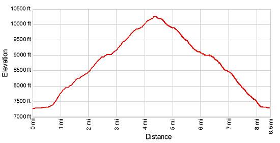
Elevation Profile
Driving Directions
Walking Directions From the Zermatt Train Station (Bahnhof): The Gornergrat Cog Railway is located directly across the street from the Zermatt Bahnhof. In the height of the summer the trains run from 7 am until 8 pm. There are also some special sunrise trains that start as early as 5 am (advanced booking required). Check at the station or the main tourist office for current schedule.
It takes 15 minutes to reach Riffelalp, 23 minutes to Riffelberg and 33 minutes to Gornergrat. During the height of the day the trains get crowded and you may need to wait to board a train. It is best to get an early start and beat the crowds.
Walking From the Zermatt Train Station (Bahnhof) to Riffelalp: The hike to Riffelalp is about 2.8 miles (depending on route) and gains 1,930-ft. Walk south/southwest on Bahnhofstrasse, the town’s main street for 0.3 miles and then turn left onto Kirchstrasse (Church Street). You will pass the Matterhorn Museum just before the turn. The Pfarrkirche St. Mauritius (church) is located on the southeast corner of Bahnhofstrasse and Kirchstrasse.
Walk down Kirchstrasse for 0.15 miles, crossing the bridge and turn right on Steinmattstrasse (Steinmatt Street), the second street past the river. The Hotel Bellerive is at the northeast corner and the Hotel Julen at the southeast. Signs at the corner now point toward Winkelmatten.
Follow Steinmattstrasse for 0.2 miles as it ascends along a narrow street and then climbs steps. At the top of the steps continue along Staldenstrasse for 0.3 miles to the small church at the center of Winkelmatten, essentially a suburb of Zermatt.
Head around the front of the church and follow the signs pointing southeast toward Riffelalp. After crossing a bridge you will see signs pointing to two routes heading to Riffelalp. One continues along the road, ascending long switchbacks. The other turns left and climbs steeply up a forested trail. The road ends at the Riffelalp Hotel while the trail ascends to the Riffelalp train station and then follows a broad track to the hotel (see the trail description above).
I prefer the trail. Note: Both trails travel through forest with occasional glimpses of the surrounding peaks. My advice is to take the train and save your time and energy for wandering the broad open meadows between Riffelalp and Gornergrat.
Trail Resources
Trail Intro / Trail Photo Gallery / Trail Map
Basecamp(s) Information:
Zermatt
Region Information:
The Valais
Other Hiking Regions in:
Switzerland