Hike Facts
- Distance: 4.0 - 6.7 miles (one way)
- Elevation: 7,723-ft. - 9,300-ft.
- Elevation Gain: 1,577-ft.
- Difficulty: moderate
- Trail Highlights: See Trail Intro
- Basecamp(s): Zinal
- Region: The Valais
This short hike leads to the Moiry Hut with stunning bird’s-eye-views of the Moiry Glacier. Extend the hike with a scenic walk along the west side of the Lac de Moiry to the Moiry Barrage (dam) at the foot of the lake.
Cabane de Moiry
Distance from Trailhead: 4.0 miles (round trip)
Ending/Highest Elevation: 9,300-ft.
Elevation Gain: 1,577-ft.
Take the postbus to Moiry Glacier. The bus stop is located beyond the head of the Lac de Moiry, a dammed reservoir to the south of Grimentz, and just before the tiny Lac de Chateaupre near the foot of the Moiry Glacier. (See trailhead directions below).
Walk a short distance south from the parking lot. Soon you will see signs pointing left (southeast) toward a broad track heading to the Cabane de Moiry (1-hr 25-min). Follow the trail as it skirts the north side of the Lac de Chateaupre, ascending through rocky meadows on easy grades. Views extend southeast to the Moiry Glacier along with the Pointes de Mourti and Pointe de Moiry, rising to the west of the river of ice.
At 0.3 miles the grade steepens as the path climbs the hillside along the east side of the glacier. Pass a junction at 0.6 miles with a trail, the Haut Tour de Lac 2500m, branching to the left toward Barrage de Moiry, Sorebois and Zinal. We continue straight ahead toward the Moiry Hut.
Beyond the junction the grade eases as the trail ascends atop the lateral moraine running along the east side of the glacier. At 0.8 miles the trail curves to the south, moving off the moraine crest to travel up a rocky gully to the left (east) of the moraine. Use trails split off from the main track and climb to viewpoints along the moraine.
At 1.3 miles the trail starts climbing a series of very steep switchbacks up a rocky hillside, gaining 800-ft. in a half mile. Turn around and look northwest for nice views of the Pointe du Tsate and Sasseneire rising above the west side of the Lac de Moiry. Directly across the valley is the Couronne de Breona.
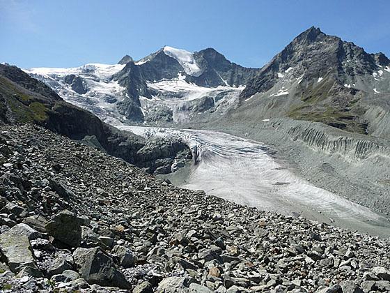
The grade abates at 1.8 miles and soon reaches the Cabane de Moiry (9,268-ft.), an old stone hut with a modern copper-clad addition, at 1.9 miles. From the hut enjoy splendid, bird’s-eye-views of the Moiry glacier.
For the best views follow a use trail which goes around the east side of the hut and then climbs to a rocky overlook (9,300-ft.) at 2.0 miles. To the north the glacier, covered with a morass of seracs and crevasses, spills down a steep incline. Pointes de Mourti, Tsa de l’Ano and Points de Moiry tower above the valley to the west. Pigne de la Le dominates the view to the south.
When you are done taking in the views, retrace your steps to the bus stop at the foot of the glacier for a 4.0 miles round trip hike.
From the Foot of the Glacier to Lac de Moiry Barrage
Distance from Trailhead: 6.7 miles (round trip)
Ending/Highest Elevation: 7,380-ft.
Elevation Gain: -343-ft.
The hike can be extended by walking to Zinal on the Haut Tour de Lac 2500m, which climbs to the Col de Sorebois and then descends to the cable car station at Sorebois, or walking to the foot of the Lac de Moiry along the west side of the lake. See the Moiry to Sorebois hike for information on the first option.
To return to the Moiry Barrage from the Moiry Glacier bus stop, walk north/northwest toward the Lac de Moiry for 0.2 miles to a trail junction on the west side of the road. Take the trail branching left (northwest) that drops steeply through meadows and then travels on easy grades along the right (east) side of the outlet stream for Lac de Chateaupre. Along the way pass a trail branching right and climbing to the road.
Rock hop across the stream at 4.4 miles and then follow the trail as it cuts across meadows to the southwest end of the Lac de Moiry at 4.6 miles. Nice views extend north across the aquamarine lake to Sasseneire rising to the west above the dam. Turn around for fine views of the Moiry Glacier. The tip of the Grand Cornier peeks above the ice sheet.
The trail now drops down to the lake and heads north, traveling along the west side of the lake on easy grades. Turn around occasionally for views of the glacier. Soon you will see the tip of Dent Blanche appear to the south of the Grand Cornier.
A rocky outcropping at the foot of the lake forces the trail to climb to meet a road at 6.2 miles. After walking a short distance along the road the trail drops down to the west end of the Barrage de Moiry (7,380-ft.) at 6.3 miles. Here signs point north to a trail dropping steeply down to Grimentz (1-hr 40-min), losing over 2,250-ft. in 3.8 miles.
We turn right (east) and cross the top of the dam on a wide paved road. Reach the cafe and bus stop at the eastern end of the barrage at 6.7 miles. During the summer regularly scheduled buses depart for Grimentz and Zinal. Buses also travel south Moiry Glacier parking area.
Note: This hike can be done in either direction. I prefer to hike to the Cabane de Moiry in the morning when skies are typically clear. Clouds are more likely to obscure views of the glacier and surrounding peaks in the afternoon.
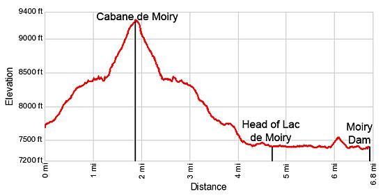
Elevation Profile
Driving Directions
From Zinal to the Moiry Glacier: From the post office in Zinal, board bus #455 bound for the Moiry Glacier. The bus ride takes 42 minutes. Note: The bus will stop at Moiry Barrage at the foot of the dam. Stay on the bus and get off at the last stop at Moiry Glacier.
From Grimentz to the Moiry Glacier: From the post office in Grimentz, board bus #455 bound for the Moiry Glacier. The bus ride takes 29 minutes. Note: The bus will stop at Moiry Barrage at the foot of the dam. Stay on the bus and get off at the last stop at Moiry Glacier.
From the Moiry Barrage to Grimentz or Zinal: At the dam, board a bus headed toward Zinal or Vissoie. There are several stops in Grimentz, about a 20 minute ride from the dam. If you are headed to Zinal, the best bet is to catch a bus going directly to Zinal. Otherwise, take the Vissoie Bus to Vissoie where you will need to change for a bus headed up valley to Zinal. The direct buses take a little over a half hour. If you need to change the ride will take an hour and 15 minute or more, depending on the time of day.
Schedules are posted at the bus stops in Zinal, Grimentz and at the dam. Alternatively, check the SBB website or the SBB app for current schedules.
Trail Resources
Trail Intro / Trail Photo Gallery / Trail Map
Basecamp(s) Information:
Zinal
Region Information:
The Valais
Other Hiking Regions in:
Switzerland