Details: Fairyland Loop 
Distance: 8.4 miles (loop)
Bryce National Park, near Bryce in South Central Utah
By: Diane Greer
Hike Facts
- Distance: 8.4 miles (loop)
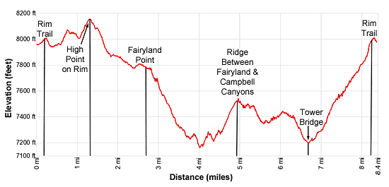
- Elevation: 7,980-ft. - 8,150-ft.
- Elevation Gain: 1,320-ft.
- Difficulty: moderate
- Trail Highlights: See Trail Intro
- Basecamp(s): Bryce
- Region: South Central Utah
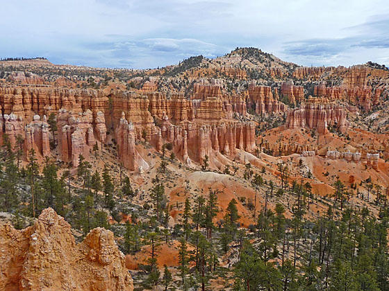
This terrific loop hike travels along the rim and then into Fairyland and Campbell Canyons with amazing views of multi-colored hoodoos, spires and fins. This path is more strenuous but less crowded than Bryce National Park’s other trails.
Fairyland Loop
The Fairyland Loop trail can be accessed from Fairyland Point, the North Campground or Sunrise Point. This description starts the hike at Sunrise Point, convenient to the park lodge, the park shuttle bus and nearby campgrounds. (See driving directions below.)
From the parking lot/shuttle bus stop at Sunrise Point, walk east toward the rim. Turn left (north) when you reach the Rim Trail. The Rim Trail features fine views of the multi-hued hoodoos, spires, fins and ridges of Bryce Canyon. Boat Mesa, a long slender peninsula, juts into the canyon to the north while Bristlecone Point (7,796-ft.) rises to the east.
At 0.2 miles reach the junction with the Fairyland Loop trail ascending from the canyon. This is the return leg of our hike. We continue heading north on the Rim Trail toward Fairy Point. The undulating trail travels through scattered trees above the head of Campbell Canyon. Along the way enjoy nice views of hoodoos, spires and fins jutting from ledges and ridges along the canyon rim.
At 1.0 miles the trail briefly leaves the rim as it climbs a hill, reaching the high point (8,150-ft.) of the hike at 1.25 miles. Here the trail turns east and descends on moderate grades, echoing the rim’s contours as it twists around the head of Campbell Canyon.
At 1.75 miles the grade moderates as the trail curves to the left (north/northeast). Here views stretch south toward Bryce Point. The path now descends on easy grades through scattered trees. At 2.4 miles we lose the views as the trail climbs over a low ridge at the western end of Boat Mesa.
At 2.5 miles amazing views open to Fairyland, a colorful sea of hoodoos, spires and pinnacles in a canyon beneath Fairyland Point. A gentle descent along the rim soon leads to Fairyland Point at 2.7 miles. This is an alternative starting location for the hike.
At Fairyland Point the trail curves to the right (south/southeast) and descends along a ridge through scattered trees. Boat Mesa rises to the south. Armies of hoodoo stand guard along the trail. The path soon leaves the ridge and switchback down into the side canyon below Fairyland Point, reaching the wash along the vegetated canyon floor at 3.4 miles.
After crossing the wash the path continues descending along the side canyon’s western slopes. At the foot of the side canyon we cross a second wash at 3.6 miles and enter Fairyland Canyon. The path now descends along the westerns slopes of Fairyland Canyon where whimsical rock formations that look like medieval castles, cathedrals and fortresses decorate the canyon walls.
At 3.9 miles the trail drops to cross the wash of a tributary canyon. This is the low point of the hike at 7,150-ft. Beyond the crossing the path climbs over a low ridge and crosses the wash of another tributary canyon at 4.25 miles and then ascends on moderate grades up to the ridge separating Fairyland and Campbell canyons. Along the way enjoy fine views of the rock formations gracing Fairyland Canyon’s east wall.
As the trail climbs toward the top of the ridge terrific views open up the length of Fairyland Canyon. Hoodoos, spires and fins carved by the elements into fantastical shapes define the walls of the canyon and its tributaries along with the slopes of Boat Mesa to the west.
Near the top of the ridge the trail swings to the right (northwest) and soon tops the ridge (7,530-ft.) at 4.8 miles. Here views open south to Bryce Point and Campbell Canyon, a "hoodoo graveyard," where the hoodoos have eroded away leaving multicolored clay mounds to mark their passing.
The trail takes a circuitous route descending into Campbell Canyon. Initially we descend along the spines of two adjoining ridges and then cross four ridges extending from Boat Mesa before a moderately-steep descent leads to a junction near the canyon floor at 6.4 miles. Along the way the well-constructed trail offers great views of the hoodoos surrounding the base of Boat Mesa along with nearby rounded, multi-colored ridges scattered with trees. The final descent to the canyon floor is accompanied by views of Tower Bridge.
Turn left at the junction, following the spur trail to the Tower Bridge viewpoint. The 0.25-miles round-trip detour leads to a viewpoint across the canyon from Tower Bridge, a natural bridge flanked by two eroded hoodoos. A window is located along fin extending from the left tower. The viewpoint is a nice place to take a break and enjoy a snack.
Return to the junction and follow the trail climbing back to the Rim Trail and Sunrise Point, gaining over 850-ft. in 1.6 miles. The path briefly ascends along the Campbell Canyon wash and then climbs on moderately-steep grades up the slopes along the west side of the canyon to a ridge topped with fin eroded into interesting spires and hoodoos at 7.1 miles. Here the trail turns left (west) along the ridge crest. A second eroded fin, dubbed the Chinese Wall, tops the ridge to the south. This photogenic rock formation includes a set of small windows.
The path crosses to the north side of the fin at 3.2 miles and then continues climbs at or near the ridge crest. Soon the path curves to the left (southwest) and ascends through scattered trees. As you climb enjoy views north toward Boat Mesa and south to Bristlecone Point.
Reach the junction with the Rim trail at 8.1 miles. From here it is 0.25 miles back to the parking area/shuttle bus stop.
Either before or after the hike be sure to visit Sunrise Point, located along the rim a short distance to the south of the trail back to the parking area.
Always carry plenty of water on this hike. The hike will take longer than the mileage indicates as you will stop often to admire the amazing rock formations gracing the canyons. During the summer this is a very hot, exposed hike.
Elevation Profile
Driving Directions
From the Bryce Canyon Visitor Center to Sunrise Point: From the Visitor Center, located along UT 63, head south on UT 63 for 0.5 miles and then turn left onto the Sunrise Point access road. Follow the access road for 0.5 miles and turn left toward the Sunrise Point parking area. There are parking spots along the side of the access road and a small lot near the trailhead. More parking is located near the General Store. These parking lots fill early in the day during the height of the tourist season.
Alternatively, take the Park Shuttle Bus to the Sunrise Point stop (stop 8). The buses run every 10-15 minutes from April to October. The shuttle bus parking lot is located along UT 63, a short distance past Ruby’s Inn (in the hotel area). Limited parking is also available at the Bryce Visitor Center (stop 1), located 2.4 miles from the parking area.
From the Bryce Canyon Visitor Center to Fairyland Point: From the Visitor Center, located along UT 63, head north on UT 63 for 0.8 miles and then turn right onto the Fairyland Point Road. Drive 1.0 mile to the end of the road and park. The trailhead is at the eastern end of the small parking area. Note: Fairyland Point is NOT on the shuttle bus route.
Trail Resources
Trail Intro / Trail Photo Gallery / Trail Map
Basecamp(s) Information:
Bryce
Region Information:
South Central Utah
Other Hiking Regions in:
Utah