Details: Lower Spring Canyon 
Distance: 8.0 - 12.0 miles (round trip)
Fruita District, Capitol Reef National Park, near Capitol Reef in South Central Utah
By: Diane Greer
Hike Facts
- Distance: 8.0 - 12.0 miles (round trip)
- Elevation: 6,050-ft. - 6,335-ft.
- Elevation Gain: 6,050-ft.
- Difficulty: moderate-strenuous
- Trail Highlights: See Trail Intro
- Basecamp(s): Capitol Reef
- Region: South Central Utah
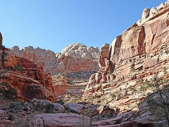
This fascinating walk down rugged Lower Spring Canyon features soaring sandstone walls, magnificent domes and two sections of twisting narrows. Minor obstacles add some challenge to the walk that starts by hiking a section of the Chimney Rock trail.
Lower Spring Canyon Trail
The hike to Lower Spring Canyon starts at the Chimney Rock trailhead. The path ascends on easy grades for 0.25 miles, with fine views of Chimney Rock – a Moenkopi formation with a Chinle formation caprock. The trail then climbs steep switchbacks up Chinle slopes to the first junction with the Chimney Rock loop trail, branching right, at 0.5 miles. We bear left on a path descending on easy grades to a second junction with the Chimney Rock loop trail at 1.3 miles. The descent is accompanied by fine views of Wingate sandstone walls rising above the trail to the north.
The path now enters Chimney Rock Canyon and descends the wash, along the way passing three large side canyons coming in on the left (northwest). As you head down canyon the Wingate sandstone walls grow in stature and the canyon narrows. In one place you will need to circumvent large boulders in the wash.
At 2.9 miles reach a signed junction at the confluence with Spring Canyon. To the left is Upper Spring Canyon. We turn right (east/southeast) into Lower Spring Canyon, a beautiful canyon with multi-hued Wingate sandstone walls towering overhead. At this point it is now 6.8 miles to the Fremont River crossing and Highway 24 at the end of the canyon.
At 4.0 miles you will encounter a short section of narrows with two 10-15-ft. dry falls. Rock cairns mark the first route that bypasses the dry falls on the left (north) side of the canyon. The second bypass, also on the left, requires hikers to climb steeply up rugged slopes along the north side of the canyon and then follow a narrow, rocky trail. At 4.2 miles the bypass trail returns to the wash.
The exposure along this section of the trail may make some hikers uncomfortable. The routes can be hazardous if wet or covered with snow/ice. Use judgement and turn around if the trail conditions are unsafe or if the exposure/conditions cause discomfort with members of you party.
Continuing downstream, each twist and turn in the canyon opens up new vistas of rugged walls soaring above the canyon floor. In places you will see spire rising atop low fins or walk beneath sheer, multi-hued walls decorated with desert varnish. The canyon constricts, opens and then constricts again, tempting you to keep walking to find out what is around the next corner.
Walking down the wash is generally easy, although you will find places where obstacles in the wash will force you to climbs over or walk around slickrock slabs. In several places you will need to weave around or scramble over boulders in the wash.
On the last trip down the canyon I turned around at 6.0 miles and then retraced my steps back to the Chimney Rock trailhead. How far you explore is dependent on your time, energy and interest. Hiker with a prearranged car shuttle can walk down canyon all the way to the Fremont River and Highway 24, a total distance of about 9.7 miles with an elevation loss of 1,110-ft. When you get to Highway 24 turn right and walk 0.2 miles west along the shoulder of the road to the unmarked parking area where you parked your shuttle vehicle.
Note: Hikers must ford the river to reach Highway 24. There is no bridge over the Fremont River. River levels are typically thigh deep and currents can make the crossing difficult. Check with the Capitol Reef Visitor Center for current conditions before planning a hike that crossing the river.
This hike is best done during the Spring and Fall when temperatures are cooler. Remember there are no guaranteed water sources along the trail so take plenty of water,. Flash floods, rock falls and other events can change conditions in the canyon at any time. Check with the Capitol Reef Visitor Center for current conditions before setting out.
Elevation Profile

Driving Directions
Capitol Reef Visitor Center to the Chimney Rock Trailhead: Turn left out of the Visitor Center on Campground Road and after 100-ft. turn left onto UT 24 West. Drive 3.0 miles and turn right into the Chimney Rock trailhead parking lot. The trail starts on the north side of the parking area.
Capitol Reef Visitor Center to Lower End of Spring Canyon on Highway 24: Turn left out of the Visitor Center on Campground Road and after 100-ft. turn right onto UT 24 East. Drive 3.7 miles to the unmarked parking areas on both sides of the highway. The end of Spring Canyon is located 0.2 miles down the road (east) of the parking area.
Trail Resources
Trail Intro / Trail Photo Gallery / Trail Map
Basecamp(s) Information:
Capitol Reef
Region Information:
South Central Utah
Other Hiking Regions in:
Utah