Details: Slickhorn Canyon – Third Fork to Trail Fork 
Distance: 10.5 miles (loop)
BLM, Monticello, Utah office, near Blanding in Southeast Utah
By: Diane Greer
Hike Facts
- Distance: 10.5 miles (loop)
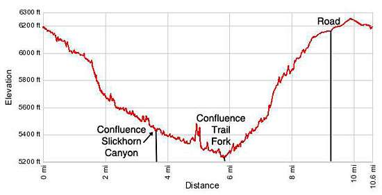
- Elevation: 6,190-ft. - 5,230-ft.
- Elevation Gain: -960-ft.
- Difficulty: moderate-strenuous
- Trail Highlights: See Trail Intro
- Basecamp(s): Blanding
- Region: Southeast Utah
This strenuous hike visits the scenic Third and Trail Forks of Slickhorn Canyon
Third Fork to Trail Fork of Slickhorn Canyon
The trailhead for the Third Fork of Slickhorn Canyon is located down a spur road off of UT-261, 9.7 miles south of the Kane Gulch Ranger Station. (See driving directions below.) From the trailhead a boot beaten path heads west and descends into the canyon. The walking is generally easy, following a descending traversing across slickrock and pack sand. Along the way watch for trails crossing the pinyon and juniper clad benches adjacent to the wash that cutoff meanders in the canyon’s course.
At 1.6 miles the trail reaches a large pour-off. Follow a bypass trail that travels along the left (south) side of the pour-off rim for a short distance. Soon you will see an opening along the rim where the trail descends to the wash.
The way now becomes more difficult as boulders and small slickrock ledges create obstacles in the wash. A short distance after passing a side canyon on the right (north) at 1.9 miles reach second large pour-off. Bypass this pour-off on the left (south).
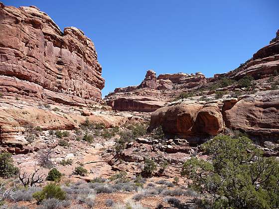
The walk is quite scenic. Sculpted red and white sandstone walls stained with desert varnish tower overhead.
At 2.5 miles the trail makes a wide “U” turn, passing two large bays on the north canyon wall. The trail now alternates between the wash and its adjacent benches, traveling through some brushy sections of the wash.
Another large amphitheater along the north wall springs into view at 3.0 miles. The bench and wash in the vicinity of the alcove is quite lush with tall grasses, junipers, willows and cottonwood trees. Just beyond the amphitheater is a large alcove situated just above the canyon floor with an interesting set of ruins including a log kiva, double deck granary and a few pictographs.
Beyond the alcove the trail travels along the bench and slickrock clad wash to the confluence with Slickhorn Canyon at 3.7 miles. At the confluence head down the sinuous canyon.
At 5.4 miles pass a prominent side canyon on the left (east). The canyon then turns to the right (west) and then back to the left (southeast), reaching the confluence of the Trail Fork of Slickhorn Canyon at 5.8 miles.
Turn left (east) and head up the Trail Fork. At 6.5 miles a cairned trail climbs the right (south) canyon wall to bypass a pour-off. As you top the pour-off look left (north) to see ruins scattered along a long narrow ledge. These ruins are known as the Big Ledge Ruins. A pair of binoculars is helpful to see the details of the structures, some of which are made of juniper logs.
Past the pour-off the route travels through a rugged section of the canyon. There is a pour-off at 7.5 and a boulder jam in the wash at 8 miles, both obstacles are bypasses on the right (south) side of the canyon. At 8.6 miles the trail climbs a series of rock ledges on the right (south) side of the canyon to detour around the final low pour-off. As you climb look left across the canyon at the north wall where you will see a small ruin tucked beneath an overhang.
The trail tops the canyon rim at 8.6 miles, emerging onto a large scrub covered field. The route now follow cattle trails heading east across the field. Soon you will reach a two track road that passes to the south of a corral. A short distance past the corral arrive at County Road #203/Point Lookout Road at 9.3. Turn left and walk 1.2 miles along the road to your vehicle parked at the Third Fork trailhead. The total distance for the loop, including the walking along the road, is 10.5 miles.
Elevation Profile
Driving Directions
Note: The roads to Slickhorn Canyon trailheads are passable with 2WD vehicle id driven carefully. Be away the roads are rutted and rough in places. High clearance or 4WD is better. The roads are impassable when wet. Enquire about current road conditions at the Kane Gulch Ranger Station before driving to the trailhead.
From Blanding: Drive south on US 191 S for 4 miles and turn right (west) on UT-95 N. Follow UT-95 for 28.4 miles and turn left (south) on UT-261 S. Head south on UT 261 for 13.6 miles and turn right (west) on County Road #245/Slickhorn Road, the dirt road located between mile posts 20 and 19. (The turn is directly across from the Cigarette Springs Road/County Road #239 and 9.7 miles south of the Kane Gulch Ranger Station.) Follow CR #245 for 2.6 miles to a “Y” intersection and bear left (south) on County Road #203/Point Lookout Road toward Slickhorn Canyon. The right fork leads to the Government Trailhead for Grand Gulch. Drive 4.5 miles on CR #203. At this point the road makes a tight turn and descends into a rocky drainage. Either park at the pullout along the left side of the road or follow a spur road on the right to a small parking area for the Third Fork Slickhorn Canyon trailhead.
If you have a second car that you wish to leave at the Trail Fork trailhead, continue down CR #203 for 1.2 miles (total of 5.7 mile from the turnoff at CR #245) and turn right on an unmarked dirt road that passes a corral. At the end of the road (~0.2 miles) is a parking area for the Trail Fork Slickhorn Canyon trailhead.
From Mexican Hat: Head north on US-163 for 3.9 miles and turn left (north) on UT-261 N. Follow UT-261 north for 19.1 miles and turn left (west) on County Road #245/Slickhorn Road, the dirt road located between mile posts 19 and 20. (The turn is directly across from the Cigarette Springs Road/County Road #239 and 9.7 miles south of the Kane Gulch Ranger Station.) Follow CR #245 for 2.6 miles to a “Y” intersection and bear left (south) on County Road #203/Point Lookout Road toward Slickhorn Canyon. The right fork leads to the Government Trailhead for Grand Gulch. Drive 4.5 miles on CR #203. At this point the road makes a tight turn and descends into a rocky drainage. Either park at the pullout along the left side of the road or follow a spur road on the right to a small parking area for the Third Fork Slickhorn Canyon trailhead. Note: a short section of UT-261 climbs steep gravel switchback up the Moki Dugway.
If you have a second car that you wish to leave at the Trail Fork trailhead, continue down CR #203 for 1.2 miles (total of 5.7 mile from the turnoff at CR #245) and turn right on an unmarked dirt road that passes a corral. At the end of the road (~0.2 miles) is a parking area for the Trail Fork Slickhorn Canyon trailhead.
Trail Resources
Trail Intro / Trail Photo Gallery / Trail Map
Basecamp(s) Information:
Blanding
Region Information:
Southeast Utah
Other Hiking Regions in:
Utah