Details: Lower Fish Creek Canyon 
Distance: 3.6 - 8.0 miles (round trip)
BLM, Monticello, Utah office, near Bluff in Southeast Utah
By: Diane Greer
Hike Facts
- Distance: 3.6 - 8.0 miles (round trip)
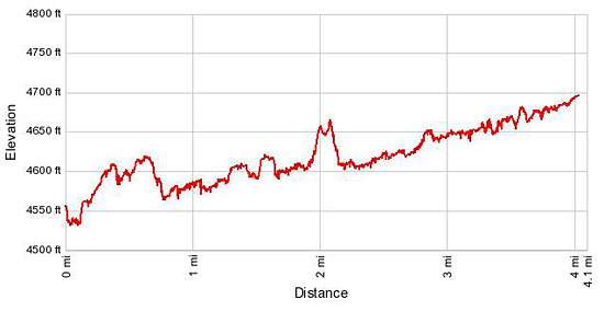
- Elevation: 4,550-ft. - 4,700-ft.
- Elevation Gain: 60-ft. - 210-ft.
- Difficulty: easy-moderate
- Trail Highlights: See Trail Intro
- Basecamp(s): Bluff / Blanding
- Region: Southeast Utah
A moderately-easy hike up a pleasant, shallow canyon with Ancestral Puebloan ruins and a few rock art sites.
To Best Ruins
Distance from Trailhead: 3.6 miles (round trip)
Ending/Highest Elevation: 4,610-ft.
Elevation Gain: 60-ft.
The trailhead for Lower Fish Creek Canyon is located down a spur road off the Comb Wash Road / Utah County Road 235. (See driving directions below.) From the southwest end of the parking area the trail travels through some brush and then drops down and crosses Comb Wash. There is typically very little water in the wash and it is fairly easy to cross without getting your feet wet.
Follow the trail as it climbs out of the wash and heads west/northwest across a scrub covered bench, staying to the right (north) of a fence line. After walking a little over 0.6 miles the trail crosses an old road and then descends into the lower end of Fish Creek Canyon, reaching the bench on the south side of the shallow canyon at 0.75 miles.
In the canyon the trail wanders along the brushy bench on easy grades. At 1.3 miles look for a small ruin (#1), possibly a granary, beneath a ledge at the base of the canyon’s right (north) wall. The ruin is located just before the canyon curves to the northwest. A short distance beyond views open to a ruin (#2) tucked in a shallow alcove and sheltered by a large overhang on the canyon’s southwest facing wall.
Reach a spur trail leading to the ruins (#2) at 1.5 miles. The trail drops down to and crosses Fish Creek wash. Large cottonwoods in the wash offer some much appreciated shade on a hot day.
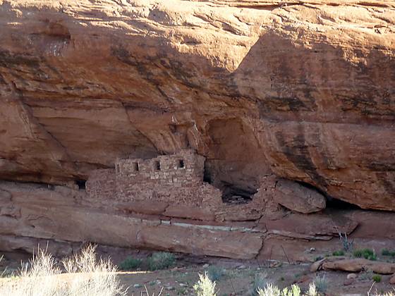
On the north side of the creek follow the trail as it climbs to the bench beneath the ruins (#2). A long, well preserved wall with four windows spans the front of the alcove. Reverse handprint pictographs are visible on the alcove’s ceiling to the left of a missing section of the front wall. Through an opening in the wall it is possible to look into the structure and see an interior wall with a door. The alcove also contains the remains of a few other structures.
Please remember when visiting an archaeology site never climb, sit or walk on the walls and do not enter the rooms. Do not touch the rock art. Oils from your hands can cause the paint to flake from the walls. Stay out of the middens, essentially the prehistoric trash mounds, typically located immediately down slope of an alcove or cliff site. Leave any pot shards, corn cobs or other relic where you found them.
When you are done exploring the ruins return to the main trail and continue hiking up canyon. A tenth of a mile past the first junction you will see an interesting ruin (#3), located in a south facing alcove where the canyon curves to the southwest.
About two-tenths of a mile beyond the spur to the prior set of ruins (#2) the trail crosses the lower Fish Creek wash. On the north side of the wash find a spur trail heading northeast, ascending the slickrock bench beneath the alcove harboring the ruins (#3) in the south facing alcove.
There are several well preserved sections of the ruin’s front wall. Gaps in the wall reveal views of the interior walls with doors leading to small rooms, some with soot coating the ceilings. On the far left side of the alcove are more structures amid piles of rubble.
Above the ruins on the left side of the alcove are reverse hand pictographs. More handprints, some quite faded, are found in the center of the alcove along the back wall. Other faded pictographs include a duck and possibly a snake.
You have now seen the two best ruins in the lower end of the canyon. Many people turn around at this point and return to the trailhead for a total hiking distance of 3.6 miles. I prefer to continue up the canyon searching for more ruins.
To View of Tower Ruin
Distance from Trailhead: 8.0 miles (round trip)
Ending/Highest Elevation: 4,700-ft.
Elevation Gain: 210-ft.
Beyond ruins #3 the trail follows the curve of the canyon as it heads southwest along the north side of the wash. At 2.25 miles (including side trips to the previous ruins), the trail crosses the wash and pass through a gate. The gates on the trail and across the wash are intended to keep cattle from wandering further up the canyon. Please make sure you close the gate behind you.
Back on the south side of the wash the trail briefly passes through a stand of cottonwoods before turning west/northwest. Soon the trail makes an ascending traverse across a scrub covered bench, cutting off a meander in the wash.
At 2.6 miles the trail crosses the wash and then climbs up moderately-steep grades as it cuts across a bench to circumvent another meander. The trail then curves to the north, following a slightly ascending traverse along a ledge high above the wash on the east side of the canyon. As the trail head north, look up at the red rock layer on the wall above the trail to see a small ruin (#4) in an alcove beneath an overhang.
The trail turns to the west at 3.25 miles and drops down to cross the wash. As you climb out of the wash and onto a bench look for a small granary or ruin (#5) stashed in a tiny alcove on the canyon’s north wall. The ruin is hard to spot. It is located in the pinkish rock just below the terracotta rock band on the canyon wall.
The trail now crosses the bench and dips in and out of the wash, repeating the process two more times in a little under four-tenths of a mile, cutting off two long meanders in the wash. Just before crossing the wash for the third time, look across the wash at the canyon wall facing southwest. Near the bottom of the wall is a granary with a horsecollar door (#6). A large flat rock closes off the lower portion of the door.
The trail now crosses the wash and curves to the west. If you have binoculars or a zoon lens on your camera, look west at this point towards two mushroom-shaped rocks atop a cliff jutting north into the canyon. On top of the rock to the left are the remains of a small ruin, possible a lookout tower on the canyon’s south rim (#7).
As you look northwest up canyon, the walls of the canyon are rising in stature. At this point you have walked about 4 miles. For many hikers this is a good turnaround point for a day hike.
Hikers and backpackers can continue wandering up the canyon toward the confluence with McCloyd and Owl Canyons. Along the way keep an eye out for another granary and small ruin on the canyon’s right (north) wall. McCloyd and Owl Canyons, in conjunction with Fish Creek Canyon, offer backpackers a variety of options for overnight trips.
Keep in mind that much of the trail up lower Fish Creek is exposed and can get quite hot in the full mid-day sun. Be sure to carry plenty of water. Check at the Kane Gulch Ranger station before starting your hike/backpack to determine the availability of water in the canyon.
Elevation Profile
Driving Directions
From Bluff: Head west on US 191 S/Main Street for 4.3 miles to the junction with US 163 S. At this point US 191 turns left (south). Continue straight ahead (west) on US-163 S for 3.7 miles and then turn right (north) on Utah County Road 235/Comb Wash Road. The turn is between miles posts 37 and 38. Follow CR-235 for 2.3 miles to a “Y” intersection. Take the right fork, staying on CR-235. Continue heading north for 6.6 miles (total distance on CR-235 is 8.9 miles) and turn left (west) on an unmarked road. There is a hiker registration and information kiosk slightly down the road. Drive 0.6 miles down the road to a parking area on the east side of Comb Wash. Park here. The trail starts at the southwest end of the parking area.
From Mexican Hat: Head northeast on UT 163 N for 16.7 miles and turn left (north) on Utah County Road 235/Comb Wash Road. The turn is between miles posts 38 and 37. Follow CR-235 for 2.3 miles to a “Y” intersection. Take the right fork, staying on CR-235. Continue heading north for 6.6 miles (total distance on CR-235 is 8.9 miles) and turn left (west) on an unmarked road. There is a hiker registration and information kiosk slightly down the road. Drive 0.6 miles down the road to a parking area on the east side of Comb Wash. Park here. The trail starts at the southwest end of the parking area.
From Blanding: Drive south on US 191 S for 4 miles and turn right (west) on UT-95 N. Follow UT-95 for 14.1 miles to and turn right (south) on the Comb Wash Road, UT County Road 235, located between mile posts 108 and 107. (The turn is right before reaching mile post 107.) Follow the dirt road for 9.4 miles and turn right (west) on an unmarked road. There is a hiker registration and information kiosk slightly down the road. Drive 0.6 miles down the road to a parking area on the east side of Comb Wash. Park here. The trail starts at the southwest end of the parking area.
Trail Resources
Trail Intro / Trail Photo Gallery / Trail Map
Basecamp(s) Information:
Bluff / Blanding
Region Information:
Southeast Utah
Other Hiking Regions in:
Utah