Details: Wolfman Panel 
Distance: 0.8 - 1.4 miles (round trip)
BLM, Monticello, Utah office, near Bluff in Southeast Utah
By: Diane Greer
Hike Facts
- Distance: 0.8 - 1.4 miles (round trip)
- Elevation: 4,530-ft. - 4,360-ft.
- Elevation Gain: -170-ft.
- Difficulty: easy-moderate
- Trail Highlights: See Trail Intro
- Basecamp(s): Bluff / Blanding
- Region: Southeast Utah
The Wolfman Panel is fascinating both for its precise artwork as well as its interesting figures. The easy access and short hiking distance make this site a popular spot for rock art enthusiasts passing through the Bluff and Mexican Hat area.
To Wolfman Panel
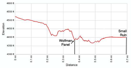
Distance from Trailhead: 0.8 miles (round trip)
Ending/Highest Elevation: 4,387-ft.
Elevation Gain: -143-ft.
The trailhead for Wolfman Panel is located down a spur road off the Butler Wash Road, 5.1 miles from Bluff, UT. From the parking area the route heads west on an old road grade, crossing packed sand and slickrock, marked with rock cairns. Along the way enjoy fine views of Comb Ridge to the west/northwest. In two-tenths of a mile reach the east rim of Butler Wash. Stop here and look across the wash. Tucked in an alcove on the wash’s western wall are a small set of ruins, which are easily visited after viewing the Wolfman Panel.
At the rim the trail curves to the south and follows a traversing descent down a moderately steep ledge along the wash’s east wall. Along the way hikers need to squeeze past a boulder and climb down a low ledge. The obstacles should not pose a problem for most hikers.
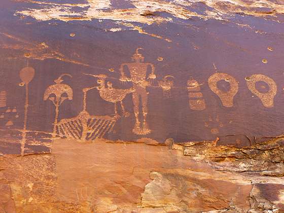
The Wolfman Panel is located in an alcove along the eastern wall, near the point where the trail makes a sharp hairpin curve and switchbacks down to the wash. The petroglyphs on this fascinating panel are precisely chipped and stand out nicely against the dark rock.
The panel includes two well executed birds, a small anthropomorph (human-like) figure with large feet and claws for hands, two small anthropomorphs holding hands and a tall slender anthropomorph with well defined hands and feet. Other figures and shapes are harder to identify. There appears to be shield, a mask and a plant. Beyond that I can only speculate on the remaining images, but that is part of the fun of viewing rock art.
Unfortunately the panel has been damaged, riddled in places with bullet holes. Remember to treat all the rock art you discover with respect so that it may be enjoyed by future generations. Rock art is extremely fragile and easily damaged. Never touch rock panels as the oil on your fingers can speed the erosion of the rock art. Do not vandalize the panels by taking latex mold prints or rubbings from rock art or adding modern additions.
To the Small Ruins
Distance from Trailhead: 1.4 miles (round trip)
Ending/Highest Elevation: 4,360-ft.
Elevation Gain: -170-ft.
If time and energy permit continue following the trail as it turn north, descending to and crossing Butler Wash. On the other side of the wash the trail climbs to an alcove with a small set of ruins. There is also a small panel of rock art within the alcove.
When you are done exploring the ruins, retrace your steps back to the trailhead.
Elevation Profile
Driving Directions
The surface of Utah County Road 262, the Butler Wash Road, is packed dirt with sections of slickrock. The road can be rutted, sandy and rough in place. Under good conditions the road is passable with a 2WD vehicle if driven carefully. High clearance or 4WD is better.
From Bluff: Drive southwest on US-191 S for 4.2 miles. Where US-191 turns south continue straight ahead on US 162 for 0.9 miles and turn right on County Road 262 / Lower Butler Wash Road. The road is located between mile posts 41 and 40 and is across from the Bluff Airport Road (County Road 269A). Almost immediately reach a gate across the road, secured by a chain. Make sure you close the gate after passing through. Drive 1.0 miles north to a spur road on the left [gps coordinates: 37.276258, -109.641381]. The spur is located right before UT CR 262 passes over a cattle guard. Turn left onto the spur and drive a short distance to a parking area.
From Mexican Hat: Drive east on US-163 for 19.6 miles and turn left on County Road 262 / Lower Butler Wash Road. The road is located between mile posts 41 and 40 and is across from the Bluff Airport Road (County Road 269A). Almost immediately reach a gate across the road, secured by a chain. Make sure you close the gate after passing through. Drive 1.0 miles north to a spur road on the left [gps coordinates: 37.276258, -109.641381]. The spur is located right before UT CR 262 passes over a cattle guard. Turn left onto the spur and drive a short distance to a parking area.
Trail Resources
Trail Intro / Trail Photo Gallery / Trail Map
Basecamp(s) Information:
Bluff / Blanding
Region Information:
Southeast Utah
Other Hiking Regions in:
Utah