Details: Amasa Back 
Distance: 8.0 - 10.4 miles (round trip)
near Moab in Southeast Utah
By: Diane Greer
Hike Facts
- Distance: 8.0 - 10.4 miles (round trip)
- Elevation: 4,000-ft. - 4,975-ft.
- Elevation Gain: 612-ft. - 975-ft.
- Difficulty: moderate
- Trail Highlights: See Trail Intro
- Basecamp(s): Moab
- Region: Southeast Utah
The Amasa Back trail offers a challenging, view packed hike to a ridge overlooking the Colorado River and the red rock country beyond.
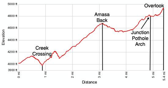
Trailhead to First Overlook
Distance from Trailhead: 8.0 miles (round trip)
Ending/Highest Elevation: 4,612-ft.
Elevation Gain: 612-ft.
Note: While I am not a big fan of hikes along 4WD roads I make an exception for the Amasa Back trail. The big slickrock ledges and challenging obstacles along the road limit the number of 4-wheelers that attempt the route. Mountain bikers now have their own trail up the Amasa Back, called Hymasa, which bypasses much of the jeep road.
My advice is to hike the road on a weekday when 4WD traffic is lightest. Avoid holiday weekends and the Jeep Rally. I only say two jeeps on my last trip up the trail. Their presence did not detract from the hike. Watching them climbing the big ledges was actually quite entertaining.
From the Amasa Back parking area (see driving directions) walk southwest up the road for 0.5 miles to the Amasa Back trailhead, marked by a large, brown BLM sign. The 4WD road (also known as the Cliffhanger) drops steeply down a cascade of ledges while a single track bike trail, the Hymasa, descends on more moderate grades down a series of switchbacks.
Either route works. I personally prefer the bike trail since it is not as steep. The two routes reconnect in 0.3 miles, just before the road crosses the creek. For the remainder of the hike stay on the road.
Cross the creek at 0.9 miles. Typically the creek is shallow and you can cross without getting your feet wet.
On the north side of the creek the trail turns southwest, travels along a dugway and then climbs a few switchbacks. At 1.2 miles, where the road curves to the right (west), look for a small rock cairn to the north of the road. The cairn marks the beginning of a rough trail to an interesting rock art panel.
To see the panel, leave the road and head northwest, climbing steeply up a rocky drainage on a boot beaten path. Near the head of the drainage the trail turns right, crosses the drainage and then ascends along a ledge. From the ledge enjoy great views of the initial section of the Amasa Back trail. Soon you will see two small panels and then a larger petroglyph panel, protected by overhangs, along the wall. The large petroglyph panel includes an owl, bighorn sheep, birds and a human figure.
Please treat all archaeology you discover with reverence and respect so that it may be enjoyed by future generations. It is truly a privilege to view the art of the ancient inhabitants of this area. Remember that rock art is extremely fragile and easily damaged. Never touch rock panels as the oil on your fingers can speed the erosion of the rock art. Do not vandalize the panels by taking latex mold prints or rubbings from rock art or adding modern additions.
(Hikers who do not wish to climb the rough trail to the panel can see the panel with binoculars from the trailhead. While standing near the BLM sign at the start of the trail, look to the left of the large alcove high in the wall across the canyon. The panel is located in the dark rock near the base of a ledge.)
When you are done viewing the panel, retrace your steps back to the road. The side trip to the panel gains over 200-ft. in just under 0.2 miles (0.4 miles round trip). The mileage for the remainder of this description will include the side trip to the rock art panel.
Beyond the switchbacks the road ascends slickrock benches, on easy to moderate grades, up the west side of Kane Creek Canyon. The walking is generally easy, traversing sections of slickrock and pack sand. At times it is necessary to climb ledges, cross rubble fields and skirt other minor obstacles. As you ascend enjoy ever improving views of the sculpted sandstone walls lining both sides of the canyon.
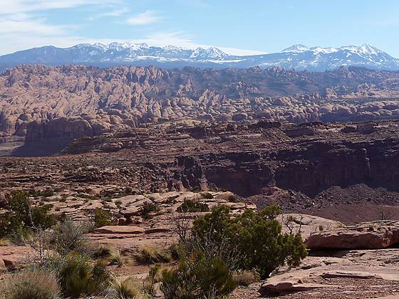
At 2.3 miles the road curves to the west away from the canyon, climbing a broad slickrock bench toward the top of Amasa Back. Massive sandstone formations tower above the landscape to the west. To the south/southeast are panoramic views of the Behind the Rocks, a maze of sandstone fins, domes and arches rising to the southwest of Moab. In the distance are the La Sal Mountains, snow-covered in the spring, offering a vivid contrast to the huge expanses of red sandstone in the foreground.
The road reaches the top of Amasa Back 3.1 miles from the parking area, having gained over 700-ft. from the creek crossing. Amasa Back is a high, elongated mesa bounded on three sides by the Colorado River and to the south by Jackson Hole, an abandoned meander on the Colorado.
The road now descends on easy grades to a junction at 3.3 miles where a spur trail to the right leads north for 0.7 miles to an overlook of the Colorado River. From this loft spot views extend across the river to Poison Spider Mesa, a popular mountain biking and 4WD area. The spur trail is a good option for hikers looking for a shorter day. The total distance out and back to the overlook is 8.0 miles round trip.
To Colorado River Overlook
Distance from Trailhead: 10.4 miles (round trip)
Ending/Highest Elevation: 4,975-ft.
Elevation Gain: 975-ft.
We continue straight ahead on a descending traverse along the “cliffhanger”, a narrow section of the road that travels along the cliff edge high above Jackson Hole. At one point the road drops down narrow, steep ledges. Scrape marks on the walls and road bed attest to the difficulty of driving through this obstacle. Hikers will have no problems drop down the ledges along the road.
To the south Jackson Butte, an isolated sandstone mesa, rises abruptly from the depths of Jackson Hole. Soon views open to the Intrepid Potash Plant across the Colorado River and the red cliffs rising above the west side of the river. Thankfully the plant is only in view for a limited time.
At 3.8 miles the road moves away from the cliffs and begins ascending on easy grades, crossing a gas pipeline providing natural gas to the potash plant across the river at 4.0 miles. A short distance past the pipeline, pass a narrow dirt road to the left (southwest). This is the Jacobs Ladder trail, an old cow path that drops over 440-ft in 0.4 miles into Jackson Hole. At 4.1 miles walk by the junction with a trail branching to the right (north), this is Jackson mountain bike trail.
Continue straight ahead, following the road as it ascends on moderate grades. As you gain elevation views open to Behind the Rock and the La Sal Mountains to the east/southeast. At 4.6 miles the jeep road curves to the right, climbing up a slickrock slopes and over a few ledges.
Where the jeep road turns an alternate, unmarked route branches off to the left. If your eyes are glued to the scenery it is easy to miss the turn on the jeep road and instead follow the alternate trail, suitable for bikers and hikers, that climbs a rise along a narrow slickrock ledge. Soon the trail turns into a single track that traverses packed sand and scrub covered flats before rejoining the main trail at 4.8 miles.
Reach a junction at 4.9 miles. The road straight ahead soon turns into a single track, the Pothole Arch Trail, which heads north along Amasa Back to Pothole Arch in 2.2 mile (one-way). To the left (south) is the continuation of the Amasa Back Road.
Turn left and follow the Amasa Back road as it travels south for half a mile through scrub cover flats and then ascends slickrock slopes on moderate to moderately steep grades to an overlook, 5.4 miles from the parking area (including side trips).
The overlook enjoys panoramic views to the east of Behind the Rocks and the La Sal Mountains. To the south and west are expansive views of the Colorado River and a sea of red rock mesas and buttes. Dead Horse State Park is located atop the high mesas to the west/southwest while the Canyon Rim Recreation area is seen in the distance to the south. As you look to the southwest, try to ignore the Potash Plant across the river.
Either before or after climbing to the overlook you may want to look for a nice rock art panel on the cliff face just to the north of the junction with the Pothole Arch trail. Before you reach the junction you should see a boot beaten trail climbing the sandy slopes to the right (north) of the trail. The trail leads to the southeastern end of the large sandstone formation to the north of the road in 0.1 miles. Here a shallow overhang shelters petroglyphs of a large bighorn sheep and two smaller sheep.
After taking in the scenic vistas at the overlook retrace your steps back to the parking area, enjoying the fabulous views on the return trip.
Elevation Profile
Driving Directions
From Moab: The Amasa Back trailhead is located along the Kane Creek Road. There are two ways to reach Kane Creek from Moab. From the north end of town, head south on US 191 S and turn right (west) on W Center Street. Drive one block and turn right (north) on N 100 W. Travel along N 100 for 200-ft and then turn left (west) on Williams Way. (This will be the second left.)
Follow Williams Way for 0.5 miles and turn left (south) on S 500 W/5th Street. Drive 0.4 miles to the end of the road and turn right (west) on Kane Creek Blvd. Kane Creek Blvd will soon curve southwest and travel along the Colorado River. After 3.8 miles the pavement ends. Continue on the gravel road (know also known as Kane Creek Road) for 0.7 miles to a large parking area along the right (west) side of the road. (There is a large dumpster in the parking lot.) Park here. To reach the trailhead walk 0.5 miles further up the road. There is a large BLM sign marking the Amasa Back trailhead.
From the south end of Moab drive north on US 191 N and turn left (west) on Kane Creek Blvd. The turn is just past the McDonalds. Kane Creek Blvd will soon curve southwest and travel along the Colorado River. After 3.8 miles the pavement ends. Continue on the gravel road (know also known as Kane Creek Road) for 0.7 miles to a large parking area along the right (west) side of the road. (There is a large dumpster in the parking lot.) Park here. To reach the trailhead walk 0.5 miles further up the road. There is a large BLM sign marking the Amasa Back trailhead.
Trail Resources
Trail Intro / Trail Photo Gallery / Trail Map
Basecamp(s) Information:
Moab
Region Information:
Southeast Utah
Other Hiking Regions in:
Utah