Details: Culvert Canyon/Jeep Arch 
Distance: 4.0 miles (round trip)
near Moab in Southeast Utah
By: Diane Greer
Hike Facts
- Distance: 4.0 miles (round trip)
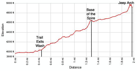
- Elevation: 3,960-ft. - 4,975-ft.
- Elevation Gain: 1,015-ft.
- Difficulty: moderate
- Trail Highlights: See Trail Intro
- Basecamp(s): Moab
- Region: Southeast Utah
Wonderful views of a stunning canyon, solitude and an impressive jeep-shaped arch more than compensate for the difficulty in following a trail, which is poorly defined in places.
Culvert Canyon
Note: Beyond the confluence of Bootlegger Canyon and the Colorado River (just to the south of the Corona Arch parking lot) a railroad track runs above the north/northeast side of the Potash Road. The track is a spur that runs from the Potash plant at the end of Utah 279/Potash Road, up Bootlegger Canyon and through a mile long tunnel to a point just west of US-191 near Moab. Past the tunnel the rail spur connects to the main rail line running north to Crescent Junction. The trail up Culvert Canyon to Jeep Arch starts at a pullout near a culvert going under the tracks, 0.3 miles past the Corona Arch trailhead. See the driving directions for more information on locating the pullout.
From the pullout follow the obvious path climbing to the large culvert. Walk through the culvert, which provides a convenient passage under the railroad tracks, and proceed up canyon beneath towering sandstone walls.
The boot beaten trail initially travels along the sandy wash but soon climbs the bench to the right (east) side of the wash. A trail sign on a brown post marks where the trail exits the wash to the right.
In a little over 0.25 miles a bypass trail climbs to the right (east) of the wash to circumvent a large pool and pouroff. At 0.4 miles a second bypass trail ascends to the right (east) to avoid another large pool and pouroff and then descends back into the wash.
Continue up the bedrock covered wash bottom for a short distance, keeping an eye out for rock cairns on the left (west) side of the wash. The cairns indicate where the trail climbs out of the wash. Note: The trail climbs out of the wash before it reaches a boulder field in the wash. If you hit the boulders turn around and look for the rock cairns.
The route out of the wash ascends ledges, climbing 90-ft. up to a slickrock bench with great views of the impressive canyon walls. Be sure to look around the area and make note of prominent landmarks so that you do not miss spot where the trail drops back into the wash on the return trip.
The cairned / boot beaten route now heads north, following an ascending traverse on easy grades along the bench high above the wash. At first the cairned trail is hard to follow across the slickrock but soon the way becomes clearer as the trail crosses sections of packed sand.
At 0.7 miles the trail curves to the left (west), tracing the contours of the canyon. Soon the trail climbs a switchback and then curves to the right, crossing a drainage and then climbing ledges to the next bench. On the higher bench the trail resumes its ascending traverse up canyon.
As you proceed up the canyon enjoy ever improving views of the canyon’s many branches cutting through a sea of sandstone terraces, cascading from the Gold Bar Rim, the high ridge to the west of Moab. Impressive multihued sandstone walls line both sides of the canyon.
The trail become hard to follow for a brief period as it negotiates a rock slide at 0.8 miles. There are two routes through the slide. Either gets you through the slide and continues ascending along the bench.
A little over a mile from the trailhead the path climbs a small rise on moderate grades and then curves left around a bend. Views open to a sandstone formation jutting from the canyon wall, topped by an impressive sandstone spire and huge fin. Follow the trail as it continues its gentle ascent to the base of the formation. Here a very steep trail climbs to the base of the spire, 1.3 miles from the trailhead. Take a break from the stiff climb to enjoy the great views that stretch east across scenic Culvert Canyon to the La Sal Mountains. To the south/southeast you can see a portion of the Behind the Rocks area to the west of Moab.
After taking in the views work your way around the right side of the spire and descend the slickrock slope to the scrub covered flats below. Here you will pick up a faint boot beaten trail ascending on easy grades to the northwest across the scrub covered flats. A small cairn marks the spot where the trail takes off from the slickrock. If you have trouble locating the trail simply head across the scrub toward the saddle (low point) in the canyon wall to the northwest.
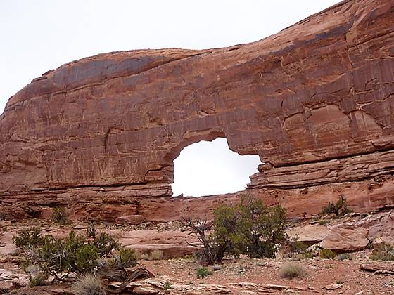
As you travel along the trail keep an eye out for the first views of Jeep Arch to the right (northeast). At 1.7 miles the trail crosses a small drainage and then climbs along the bench to the right (east) of the drainage toward the arch, locate on the southwest facing wall of a large sandstone cul-de-sac. The trail ends at a great viewpoint right beneath the photogenic arch, 1.9 miles from the trailhead.
It is possible to climb up to and stand in the arch. Views from the opening extend north and east to the Gold Bar Rim, a popular 4WD area. Adventurous hikers can walk through the arch and walk down the boot beaten path on the other side, following a route looping to the south and back down the canyon. Otherwise, simply turn around and retrace your steps back to the trailhead, enjoying the beautiful views of the scenic canyon on the return trip.
Plan on devoting more time then indicated by the mileage to do this hike. The fine scenery and route finding along a few sections of the trail will slow you down. Outdoor enthusiasts looking for a full day of hiking should have no problem doing the Culvert Canyon trail and the nearby Corona Arch trail in the same day.
This trail is best enjoyed during the spring and fall when temperatures are mild. Hiking is not recommended in the summer when temperatures often exceed 100 degrees F. There is little or no shade along most of the route. Take plenty of water. Do not depend upon finding any water along the route.
Elevation Profile
Driving Directions
From Moab: Drive north on Highway 191 N for 4.1 miles and turn left (west) on the UT 279 / Potash Road. Follow Potash Road for 10.2 miles and park at the pullouts on the right (north) side of the road near a large culvert going under the railroad tracks. The pullouts are 0.3 miles past the Corona Arch parking area.
Trail Resources
Trail Intro / Trail Photo Gallery / Trail Map
Basecamp(s) Information:
Moab
Region Information:
Southeast Utah
Other Hiking Regions in:
Utah