Details: Hidden Valley 
Distance: 4.9 - 7.3 miles (round trip)
near Moab in Southeast Utah
By: Diane Greer
Hike Facts
- Distance: 4.9 - 7.3 miles (round trip)
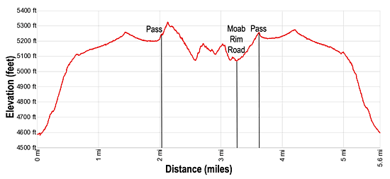
- Elevation: 4,580-ft. - 5,325-ft.
- Elevation Gain: 745-ft.
- Difficulty: moderate
- Trail Highlights: See Trail Intro
- Basecamp(s): Moab
- Region: Southeast Utah
Fine views of the Behind the Rocks and the La Sal Mountains along with the option to see great rock art panels make this a recommended hike.
Hidden Valley
4.9 miles RT – Hidden Valley Trail and the first set of Rock Art Panels 5.6 miles RT – Hidden Valley Trail and both sets of Rock Art Panels 7.3 miles (one-way shuttle hike) – Hidden Valley Trail, first set of Rock Art Panels and the Moab Rim Road to Kane Creek Road
The Hidden Valley trailhead is located 4 miles south of the center of Moab along the base of the Moab Rim (see driving directions below). A kiosk at the south end of the parking area marks the start of the trail. Follow the path as it heads south. Almost immediately the path splits with the Pipe Dream trail, an advanced single track mountain bike trail, branching right. We bear left on the Hidden Valley trail that climbs steeply up the rocky eastern flanks of the Moab Rim.
Soon the trail curves to the right (west) and crosses a wash. Beyond the wash switchbacks facilitate the stiff climb up rugged, boulder-strewn slopes. After walking a half mile the trail swings to the northwest.
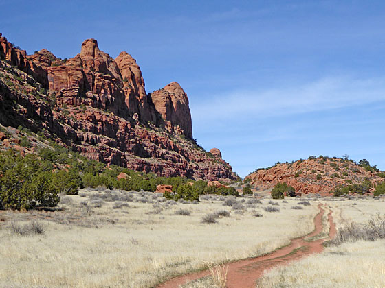
At 0.6 miles the grade abates as the path reaches Hidden Valley, a broad shelf nestled between a low ridge to the northeast and rugged cliffs of the Moab Rim to the southwest. The trail now ascends gradually through a rocky landscape that gives way to lovely grassy flats scattered with junipers and sage.
At 1.4 miles the path climbs over a low rise and then continues along the grassy shelf for a half mile to the end of the valley. Here the path climbs a hill to a saddle at 2.0 miles. From the saddle enjoy fine views of Behind the Rocks, an area of massive fins and domes along the western slopes of the Rim. The La Sal Mountains, snow-capped in the spring, dominate the skyline to the southeast.
At the top of the pass the trail splits. The main trail continues over the saddle, descending 0.25 miles to the Moab Rim Trail, a difficult 4WD dirt/slickrock track that drops steeply over 4.1 miles to the Kane Creek Road along the Colorado River.
The Rock Art Trail
I highly recommend turning right (northwest) on a use trail toward a large sandstone formation. As you near the formation the trail splits again. Bear left here, hiking along the south side of the cliff. Soon you will see a BLM sign attached to a boulder asking you to not to damage the irreplaceable rock art along the trail. Altering, defacing, or damaging the petroglyphs is against the law.
Remember to treat all the rock art you discover with respect so that it may be enjoyed by future generations. Rock art is extremely fragile and easily damaged. Never touch rock panels as the oil on your fingers can speed the erosion of the rock art. Do not vandalize the panels by making rubbing or adding modern additions. If you come across artifacts such as pottery shards, leave them where you find them.
Beyond the boulder with the BLM sign the trail travels along the cliff face, visiting a number of interesting rock art panels that contain depictions of antelope, deer, bear paws, human figures, anthropomorphs and abstract designs. Some of the panels seem to show hunting scenes, others portray groups of people holding hands. One of the most interesting carvings shows an anthropomorph inside the belly of another anthropomorph.
The trail gently descends along the cliff face and at 2.5 miles reaches a junction. The trail to the left drops down to the Moab Rim Road, a dirt track. Upon reaching the road turn left and climb on moderate grades to the end of the road. Here you will find a sign and the beginning of the Hidden Valley trail ascending to the saddle at 2.9 miles. From the saddle retrace your steps on the Hidden Valley trail to the parking lot for a 4.9 miles hike.
If time and energy permit, I recommend continuing straight ahead at the junction, following the use trail as it curve around the end of the cliff and then drops down to the slickrock floor of a short side drainage.
Turn right and travel up the drainage on the slick rock that soon gives way to a use trail. Near the head of the drainage the trail turns north, climbing up the south-facing slopes of the drainage to a ledge running along the base of a cliff face. Here you will find more petroglyph panels by heading west along the ledge.
At 2.8 miles reach the end of the ledge. Turn around and retrace your steps back to the junction where you can drop down to the Moab Rim road, reaching the dirt track at 3.2 miles. Hiker with a car shuttle can turn right at the junction and travel along the Moab Rim road for 4.1 miles to the Kane Creek Road at 7.3 miles. Note: The end of the road drops steeply down slickrock ramps.
To return to the Hidden Valley trailhead, turn left on the Moab Rim Road and ascend the road and then the Hidden Valley trail to the saddle at 3.5 miles. From the saddle, follow the Hidden Valley trail as it descends along the grassy shelf and then drops steeply down to the trailhead parking lot for a 5.6 mile round-trip hike.
Elevation Profile
Driving Directions
From Moab, UT to the Hidden Valley Trailhead: From Center Street and Main Street/US 191 in Moab, head south on Main Street/US 191 S for 3.9 miles and turn right onto West Angel Rock Road. (The turn is just after the Moab Dental Health Center.) Follow Angel Rock for 0.4 miles and then turn right onto Rim Rock Lane. Drive 0.2 miles to the end of the road. Here a spur road branches left to the Hidden Valley and Pipe Dream trailheads. The Hidden Valley trailhead is located at the south end of the parking area.
From Moab, UT to the Kane Creek Trailhead (car shuttle option): From Center Street and Main Street/US 191 in Moab, head west on W Center Street for one block and then run right onto North 100 W Street. Take the second left onto Williams Way. Follow Williams Way for half a mile and then turn left onto S 500 W Street. Drive on S 500 W Street for 0.4 miles to where the road ends at Kane Creek Blvd. Turn right onto Kane Creek Blvd. Follow Kane Creek for 1.9 miles and then turn left into the Moab Rim trailhead and park.
Trail Resources
Trail Intro / Trail Photo Gallery / Trail Map
Basecamp(s) Information:
Moab
Region Information:
Southeast Utah
Other Hiking Regions in:
Utah