Details: Mill Creek Canyon (North Fork) 
Distance: 1.6 - 5.0 miles (round trip)
near Moab in Southeast Utah
By: Diane Greer
Hike Facts
- Distance: 1.6 - 5.0 miles (round trip)
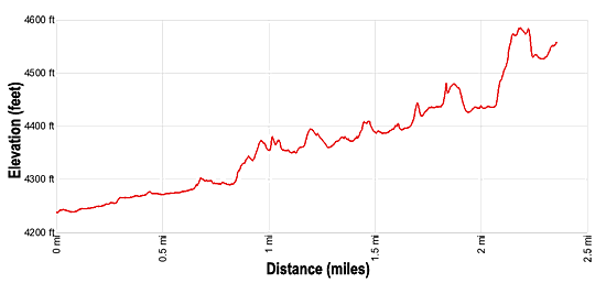
- Elevation: 4,240-ft. - 4,590-ft.
- Elevation Gain: 350-ft.
- Difficulty: moderate
- Trail Highlights: See Trail Intro
- Basecamp(s): Moab
- Region: Southeast Utah
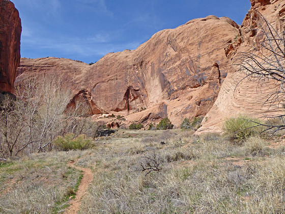
Towering sandstone walls, a perennial stream, waterfalls, swimming holes and rock art are the highlights of this interesting trail exploring scenic Mill Creek Canyon in southeast of Moab.
Mill Creek Canyon
The Mill Creek trail starts at the northeast end of the trail head parking area. (See driving directions below). Head east on the wide dirt path, ignoring any trails branching left toward the creek.
After about 800-ft. arrive at the base of a small waterfall at the site of an old power plant. Bypass the falls on the right (south), using a slick rock ledge to climb around the cement block dam and then walk along a narrow slickrock shelf beside the creek. Some may find the traction along the angled shelf problematic. If this is the case, wade in the creek.
Soon the canyon widens and a good path travels through grass and sage covered flats along the south side of the creek. Ahead make note of the shallow alcove with the dark background midway up the north canyon wall.
At 0.5 miles the canyon curves to the right. Look up at the shallow alcove to see petroglyphs pecked into the dark desert patina covering the interior of the alcove. A camera with a zoom lens or binoculars will help you get a better view.
The canyon narrows as it comes to the confluence of the South Fork of Mill Creek, branching to the right, with the North Fork of Mill Creek. Find a place to cross the north side of the creek and continue heading east up the North Fork of Mill Creek. A short distance past the confluence, there are some large boulders with petroglyphs on the south side of the creek.
Remember to treat all the rock art you discover with respect so that it may be enjoyed by future generations. Rock art is extremely fragile and easily damaged. Never touch rock panels as the oil on your fingers can speed the erosion of the rock art. Do not vandalize the panels by making rubbing or adding modern additions. If you come across artifacts such as pottery shards, leave them where you find them.
A well-used trail now travels up the north side of the creek leading to large pool beneath a high sandstone ledge at 0.8 miles. A pretty waterfall cascades down the right side of the ledge. The pool is popular with the locals offering a great place to relax and cool off, so don’t expect solitude.
It’s not possible to climb around the falls at this point, instead turn around and backtrack about 100-yards to a trail leading through the trees and up slickrock ledges along the north side of the canyon. This is the bypass trail for the falls.
Follow the bypass trail as it climbs up and along slick rock ledges, passing a nice overlook above the falls. Past the falls you leave the crowds behind as the trail continues up the north side of the canyon.
After about a mile you will see a large alcove along the north side of the canyon. Hikers comfortable ascending slick rock ramps should be able to climb up into the alcove that contains both pictographs and petroglyphs. Across from the alcove are more petroglyphs.
At 1.5 miles reach a second large pool blocking forward progress. To circumvent the pool, backtrack a short distance and find a bypass trail on the north side of the canyon that climbs around the obstacle. About 0.4 miles past the second pool look for pictographs in a low alcove on the north side of the canyon. Here you will find red handprints and a few other figures.
Around the 2.0 miles mark the canyon curves to the southeast. As you navigate the curve, look for a short slot canyon along the north wall. Climb slickrock ledges to explore the slot and a nearby alcove devoid of rock art. The next half mile is a scenic section of the canyon with soaring sandstone walls. This is a good turn around point.
Hikers looking for a longer day can continue exploring up the canyon. The trail now crosses benches, staying away from the stream bed except to cross to the other side. The canyon widens and the walls are lower here. At 4.0 miles reach the confluence of Mill Creek with Rill Creek. This is another good turn around point.
Look for more petroglyphs along the canyon walls on the way back to the trailhead. By now it is probably warm enough to justify a quick dip in one of the pools or to simply stop and rest in the shade along a ledge while enjoying the beautiful canyon.
Elevation Profile
Driving Directions
From Moab, UT: From Center Street and Main Street/US 191 in Moab, head south on S Main Street/ US 191 S for one block and turn left onto E 100 S Street. Follow E 100 S Street for 4 blocks (0.4 miles) and turn right on Fourth East Street. Head south on Fourth East Street for 0.3 miles and turn left onto S Mill Creek Drive. (Dave’s Corner Market is at the corner where you turn.) Follow South Mill Creek east for 0.5 miles and then bear right to stay on South Mill Creek Drive. Continue on South Mill Creek Drive for 0.5 miles and then turn left on Powerhouse Lane. Drive 0.6 miles to the end of the road and the parking area for the Mill Creek Trailhead. The trail starts at the northeast end of the parking area.
This is a popular area and the parking lot fills early on a nice day.
Trail Resources
Trail Intro / Trail Photo Gallery / Trail Map
Basecamp(s) Information:
Moab
Region Information:
Southeast Utah
Other Hiking Regions in:
Utah