Backpack: Cook - Island Lakes Loop 
Distance: 32.6 miles (loop)
Bridger Wilderness, Bridger-Teton National Forest, near Elkhart Park in Wyoming's Wind River Range
By: Diane Greer
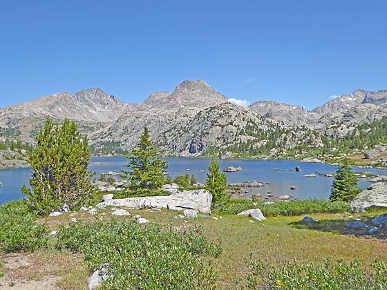
Mount Lester from the south end of Upper Cook Lake
The Pole Creek Trail, in conjunction with a segment of the Highline trail, is used to create an interesting and highly scenic loop that explores the Cook Lakes, crosses panoramic Lester Pass, visits the stunning Island Lake area and then returns to the trailhead via the Seneca Lake and Pole Creek trails.
- Distance: 32.6 miles
- Elevation: 9,340-ft. at Elkhart Park Trailhead
10,090-ft. at Junction Miller Lake Trail
10,350-ft. at Photographers Point
10,300-ft. at Junction Seneca Lake Trail
10,400-ft at Marys Lake
9,730-ft. at Lower Pole Creek Crossing
10,040-ft. at ridge above Pole Creek Lakes
9,960-ft. at middle Pole Creek Crossing
10,060-ft. at Junction Highline/Fremont Trails (Cook Lakes East Access)
10,170-ft. at Upper Cook Lake
10,060-ft. at Junction Highline/Fremont Trails (Cook Lakes East Access)
10,175-ft. at Lake 10175
10,565-ft. at Tommy Lake
11,060-ft. at Lester Pass
10,400-ft. at Junction Seneca Lake and Highline Trails
10,640-ft. at High point of trail to Island Lake
10,410-ft. at Island Lake
10,400-ft. at Junction Seneca Lake and Highline Trails
9,995-ft. at Low point west of Seneca Lake
10,300-ft. at Junction Pole Creek Trail
10,350-ft. at Photographers Point
10,090-ft. at Junction Miller Lake Trail
9,340-ft. at Elkhart Park Trailhead - Difficulty: strenuous
- More Hikes in:
Elkhart Park / Wyoming's Wind River Range
Introduction
Backpackers looking for a more leisurely and scenic trip to Island Lake should consider this lollipop loop that travels through pretty lake basins to the Pole Creek Lakes, visits the beautiful Cook Lakes, climbs over panoramic Lester Pass -- the highest point along the Highline trail, and then visits stunning Island Lake. The return to the trailhead is along the traditional Island Lake “highway”.
The backpack initially follows the standard route to Island Lake along the Pole Creek Trail, predominately through viewless forest. The monotony of this section of the trail is broken briefly by distant view of the high peaks from the meadows of Millers Park and at the aptly named Photographer’s Point, an overlook offering an impressive vista of the high peaks rising above the Upper Fremont Valley and Island Lake vicinity.
After 5.6 miles the trail reaches a junction where the hordes traveling to Island Lake turn left on the Seneca Lake trail. We continue on the Pole Creek Trail that turns right (southeast), traverses the western shores of Eklund Lake and then climbs moderately graded switchbacks to the Top Lakes. The ascent is accompanied by great views of the high peaks to the north seen from Photographer’s Point.
The path now travels by the Top Lakes and Mary’s Lake before descending through a succession of small, pretty lake basins to a junction with the Highline trail at the Pole Creek Lakes. Here we turn left (northeast) on the Highline Trail toward and Cook Lakes. Just beyond the junction the Highline crosses Pole Creek and then ascends through a beautiful area of meadows and forested knobs to the southeast of Pole Creek.
After climbing over a low ridge the trail reaches an unmarked junction at the middle crossing of Pole Creek. We don’t cross the creek but instead continue along the Highline to a junction with the Fremont Trail. Turn right on the Fremont and follow the trail for a short distance to the signed junction with the trail climbing along the eastern side of the Cook Lakes basin.
Turn onto the Cook Lakes trail and follow the scenic path as it ascends along the east side of the two Cook Lakes, separated by a timber-clad ridge. The beautiful basin is set amid a backdrop of Mount Lester (12,342-ft.) and the high summits rising above the upper Pole Creek Valley. Beyond the upper lake a use-trail leads to an overlook above the south end of photogenic Wall Lake, set beneath the soaring granite slopes of an unnamed peak to the west. From the overlook a route travels above the lake’s eastern shores to the head of the lake and the spectacular upper Pole Creek Valley.
After exploring the Cook Lakes, return to the Highline and head northwest toward Lester Pass. Almost immediately the trail crosses the knee-deep Pole Creek and soon passes a junction with a second trail that climbs along the west side of the Cook Lakes. The trail now climbs towards Lester Pass.
The climb to the pass ascends through forest which gives way to pretty meadows with views of Mount Lester (12,342-ft.) and Peak 11740. Along the way pass Lake 10175 and Tommy Lake (10,565-ft.). A final steep climb up talus slopes leads to Lester Pass (11,060-ft.), the highest point along the Highline Trail. The pass, a broad saddle clad in alpine meadows, sits atop the ridge extending southwest from Mt. Lester. As you cross to the south side of the saddle a breathtaking scene springs into view. To the north a sea of jagged peaks towering above Titcomb Basin, Island Lake and the Fremont Valley fills the skyline.
The trail now drops down rocky meadows along the south side of the pass and then descends through a pretty lake basin to a junction with the Highline and the Seneca Lake trails. Turn right (northeast) on the Highline trail which climbs steep switchbacks up a rocky draw to the top of a ridge where great views open to Fremont Peak (13,745-ft.) and Jackson Peak (13,517-ft.).
Descend from the ridge to a junction. Here the Highline trail turns left (northwest) toward Fremont Crossing and the Jean Lakes. We continue straight ahead (downhill) toward Island Lake on the Indian Pass trail, which crosses a small pass with great views of the high summits towering above Titcomb Basin and upper Fremont Creek.
The trail now climbs over a second ridge and descends to a viewpoint above Island Lake with a jaw-dropping panorama of the high peaks rising above Titcomb and Indian Basins. From the viewpoint a steep descent leads to shores of Island Lake, one of the most popular destinations in the Winds.
Try to allocate time in your schedule for day hiking around Island Lake. Favorite destinations include the scenic trail to stunningly Titcomb Basin and the terrific walk to Indian Pass that climbs through the starkly beautiful Indian Basin. Parties looking for an easier day can wander around Island Lake, visiting waterfalls and the pretty lake basin to the northeast of the lake.
From Island Lake, the heavily trafficked exit route back to Elkhart Park uses a combination of the Indian Pass, Highline, Seneca Lakes and Pole Creek Trails. Due to numerous ascents and descents, the 12.1 miles (one-way) route is more strenuous then the mileage and net elevation loss might imply. Some parties take two days to reach Elkhart Park, camping at one of the many lakes long the way.
Backpack Segments
- Segment 1: Pole Creek and Highline Trails to Cook Lake Junctions
- Segment 2: Cook and Wall Lakes
- Segment 3: Pole Creek to Little Seneca Lake via Lester Pass
- Segment 4: Little Seneca Lake to Island Lake
- --- Side Trip: Titcomb Basin
- --- Side Trip: Indian Basin and Pass
- --- Side Trip: Island Lake Waterfall Day Hike
- Segment 5: Island Lake to Elkhart Park
Elevation Profile
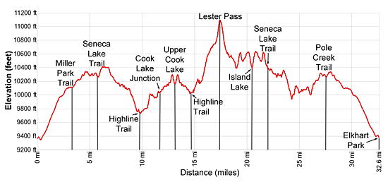
Mileage and Elevation Detail
| Miles | Elevation | Destination | |
|---|---|---|---|
| 0.0 | 9,340-ft. | Elkhart Park Trailhead | |
| 3.3 | 10,090-ft. | Junction Miller Lake Trail | |
| 4.6 | 10,350-ft. | Photographers Point | |
| 5.6 | 10,300-ft. | Junction Seneca Lake Trail | |
| 6.5 | 10,400-ft. | Marys Lake | |
| 9.8 | 9,730-ft. | Lower Pole Creek Crossing | |
| 10.7 | 10,040-ft. | Ridge above Pole Creek Lakes | |
| 11.2 | 9,960-ft. | Middle Pole Creek Crossing | |
| 11.7 | 10,060-ft. | Junction Highline/Fremont Trails (Cook Lakes East Access) | |
| 13.1 | 10,170-ft. | Upper Cook Lake | |
| 14.5 | 10,060-ft. | Junction Highline/Fremont Trails (Cook Lakes East Access) | |
| 15.5 | 10,175-ft. | Lake 10175 | |
| 16.3 | 10,565-ft. | Tommy Lake | |
| 17.4 | 11,060-ft. | Lester Pass | |
| 19.1 | 10,400-ft. | Junction Seneca Lake and Highline Trails | |
| 20.5 | 10,410-ft. | Island Lake | |
| 21.9 | 10,400-ft. | Junction Seneca Lake and Highline Trails | |
| 22.9 | 9,995-ft. | Low point west of Seneca Lake | |
| 27.0 | 10,300-ft. | Junction Pole Creek Trail | |
| 28.0 | 10,350-ft. | Photographers Point | |
| 29.3 | 10,090-ft. | Junction Miller Lake Trail | |
| 32.6 | 9,340-ft. | Elkhart Park Trailhead |
Trailhead Driving Directions
Directions from Pinedale: From the intersection of Pine Street (US 191) and North Tyler Ave (the Pinedale Tourism office is located on the northeast corner) in Pinedale, WY, drive east on Highway 191 (East Pine Street) for 0.3 miles and bear left onto Fremont Lake Road. Follow this road for 14.3 miles and turn right into the large parking area for the Elkhart Park/Pole Creek Trailhead. After the first 3.0 miles the road will turn into Skyline Drive/Forest Service Road 370740. The trailhead is located at the northeast end of the parking lot between the outhouse and the trailhead kiosk. It should take about 25 minutes to drive the trailhead. The last section of the road has some holes and uneven spots.
Trail Resources
Trail Photo Gallery / Trail Map
Basecamp(s) Information:
Elkhart Park
Region Information:
Wyoming's Wind River Range
Other Hiking Regions in:
Wyoming