Backpack: Green River Lakes to Island Lake & out Elkhart Park
Side Trip: Peak Lake
Distance: 1.8 miles (one way)
Bridger Wilderness, Bridger-Teton National Forest, near Green River Lakes in Wyoming's Wind River Range
By: Diane Greer
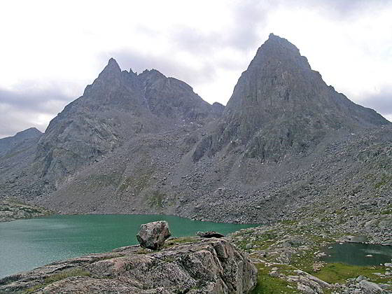
Stroud Peak
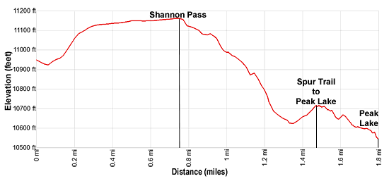
- Distance: 1.8 miles
- Elevation: 0.0 miles at Junction Shannon Pass/Highline (10,950-ft.)
0.7 miles at Shannon Pass (11,160-ft.)
1.8 miles at Peak Lake (10,515-ft.) - Difficulty: moderate
- Basecamp: Green River Lakes
- Region: Wyoming's Wind River Range
Peak Lake Description
From the junction of the Highline and Shannon Pass trails at the head of the Elbow Lake basin, turn left (northwest) on the Shannon Pass trail toward the pass and Peak Lake. The trail descends on easy grades to cross a stream and then climbs on moderate to moderately steep grades through rocky meadows towards the obvious saddle on the ridge between Mount Oeneis (12,232-ft.) and Stroud Peak (12,198-ft.). Behind you are nice views of Elbow Peak (11,948-ft.) towering above the Elbow Lake Basin to the southwest. To the southeast Henderson Peak, G17 and the other high peaks rising above Upper Jean Lake dominate the view.
After 0.3 miles the grade abates as the trail now ascends gradually across a broad plateau clad in alpine tundra strewn with rocks. This area can be quite soggy early in the season. At 0.7 miles the trail crests Shannon Pass (11,160-ft.) as it passes to the right (east) of two ponds. Stroud Peak soars above the east side of the broad saddle.
Descend on moderately-steep to steep grades rocky switchbacks down the north side of the pass. Along the way you will skirt the east side of another small pond. Views soon open to beautiful Peak Lake, cradled in a rocky bowl surrounded by rugged peaks. As you near the lake the trail actually climbs a bit to a junction at 1.5 miles with the continuation of the Shannon Pass Trail to Cube Rock and Vista passes. A short climb to the left (west) leads to Cube Rock Pass and Dale Lake (10,685-ft.). We turn right (northeast) on a spur trail dropping down to the northwest shore of Peak Lake (10,515-ft.) at 1.8 miles.
Peak Lake, a turquoise jewel, lies at the foot of a magnificent cirque of jagged 12,000- and 13,000-ft. peaks. From the western shore views extend west to a trio of captivating peaks; G4 (12,845-ft.), Split Mountain (13,155-ft.) and Twin Peaks (13,185-ft.). Knapsack Col, a pass on the route crossing to Titcomb Basin, lies to the south of Twin Peaks. Photogenic, pyramid-shaped Stroud Peak and Sulphur Peaks dominate the view along the lake’s southern shore.
The headwaters of the Green River, emanating from the Stroud Glacer tucked into a bowl beneath the east facing slopes of Stroud Peak, flows into the east side of Peak Lake. The lake’s outlet stream along the north shore, cascades down a steep gully lined with talus slopes into Stonehammer Lake, which drains into the Green.
Scenic, albeit exposed, campsites are located above Peak Lake’s western shore. More camping is available at Dale Lake.
The Route to Knapsack Col: A very strenuous route travels through the talus slopes above the north side of Peak Lake and then ascends a rugged cirque, initially along the lake’s inlet stream, to Knapsack Col. The final climb to the Col is up steep scree slopes. Backpackers making it to the top of the Col, a saddle on the ridge between Twin Peaks and Winifred Peak (12,775-ft.), are rewarded with breathtaking views of the high peaks towering above the head of Titcomb Basin. On the east side of the pass the route descends on extremely steep grades down Twins Glacier and talus slopes to the basin.
Note: This route should only be attempted by experienced parties comfortable with route finding and climbing/descending steep scree slopes, which may be partially covered with snow and/or ice. This route can be quite hazardous depending on the condition of the glacier and/or if a snow cornice is present at the top of the pass. Carry an ice axe and crampons for safety. Check on current condition at the ranger station or the Great Outdoor Store, both located in Pinedale. Be prepared to turn around if conditions are unfavorable.
Return to Segment 2: Highline: Trail Creek Park to Elbow Lake
Go To Segment 3: Highline: Elbow Lake to Indian Basin Trail
Elevation Profile
Backpack Segments
- Introduction: Green River Lakes to Island Lake & out Elkhart Park
- Segment 1: Highline: Green River Lakes to Trail Creek Park
- Segment 2: Highline: Trail Creek Park to Elbow Lake
- --- Side Trip: Peak Lake
- Segment 3: Highline: Elbow Lake to Indian Basin Trail
- --- Side Trip: Island Lake Backdoor
- Segment 4: Indian Pass Trail to Island Lake
- --- Side Trip: Titcomb Basin
- --- Side Trip: Indian Basin and Pass
- --- Side Trip: Island Lake Waterfall Hike
- Segment 5: Island Lake to Elkhart Park
Driving Directions to New Fork Lakes Trailhead
Green River Lakes Trailhead: Located just off the northwest shore of scenic Green River Lake, the trailhead offers access to several trails including the Highline Trail, which is part of the Continental Divide National Scenic Trail, Clear Creek Trail, and the Roaring Fork Trail.
Directions from Pinedale: From the intersection of Pine Street (US 191) and North Tyler Ave (the Pinedale Tourism office is located on the northeast corner) in Pinedale, WY, drive west on Highway 191 (West Pine Street) for 6 miles and then turn right on WY-352 toward Cora. Follow WY-352 for 25.3 miles to the National Forest boundary, where the pavement ends. Continue straight ahead on Green River Lakes Road (Forest Service Road 600). (Stay along the east side of the river, ignoring any roads branching to the left.)
Follow Green River Lakes Road for 18.5 miles to a signed intersection for the Green River Lakes campground and trailhead. The road to the right leads to the campground. We bear slightly left, staying on the Green River Lakes Road. Continue on the road for 0.2 miles and then turn left at the signed intersection for the trailhead parking area. Drive along the spur road for 0.1 miles to a “Y” intersection and turn right into the trailhead parking area. The road to the left leads to the equestrian parking lot. The trailhead is located at the southwest end of the parking area.
The 50 mile trip should take about 1 hour and 45 minutes. Passenger cars can typically make it to the trailhead. Check at the forest service office in Pinedale for current road conditions.
Elkhart Park Trailhead: From the intersection of Pine Street (US 191) and North Tyler Ave (the Pinedale Tourism office is located on the northeast corner) in Pinedale, WY, drive east on Highway 191 (East Pine Street) for 0.3 miles and bear left onto Fremont Lake Road. Follow this road for 14.3 miles and turn right into the large parking area for the Elkhart Park/Pole Creek Trailhead. After the first 3.0 miles the road will turn into Skyline Drive/Forest Service Road 370740. The trailhead is located at the northeast end of the parking lot between the outhouse and the trailhead kiosk. It should take about 25 minutes to drive the trailhead. The last section of the road has some holes and uneven spots.
Trail Resources
- Backpack Intro
- Segment Photo Gallery
- Segment Map
- Trailhead(s) Information: Green River Lakes
- Region Information: Wyoming's Wind River Range
- Other Hiking Regions in: Wyoming