Details: Green River Lakes Day Hike 
Distance: 6.2 - 10.6 miles (round trip)
Bridger Wilderness, Bridger-Teton National Forest, near Green River Lakes in Wyoming's Wind River Range
By: Diane Greer
Hike Facts
- Distance: 6.2 - 10.6 miles (round trip)
- Elevation: 8,040-ft. - 8,130-ft.
- Elevation Gain: 90-ft.
- Difficulty: easy-moderate
- Trail Highlights: See Trail Intro
- Basecamp(s): Green River Lakes
- Region: Wyoming's Wind River Range
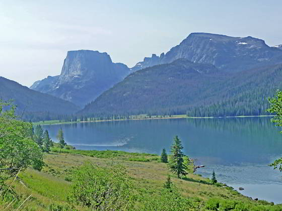
This easy, popular day hike features terrific views of the Green River Lakes, the Green River and Squaretop Mountain.
Green River Lakes
The Highline Trail starts at the southwest end of the Green River Lakes trailhead parking lot near an old cabin. Follow the trail as it curves to the left (east) and descends on easy grades through trees. Soon the horse trail joins from the left as the trail curves to the right and drops down to meadows along the northwest side of the Green River. Here views open to Squaretop Mountain (11,695-ft.), framed by the White Rock cliffs, rising to the east, and the high plateau formed by a trio of 11,000-ft peaks to the west.
In the meadows ignore the use trail branching right toward the lakeshore. At 0.3 miles the path briefly turns to the left (north) as it crosses a good wood bridge over the Green River and then curves back to the right (east/southeast), swinging around the foot of lower Green River Lake (7,961-ft.). In route, pass the old cabins from the historic Osborn homestead and the junction with the Highline Trail heading north toward the Roaring Fork Basin.
Along the east side of the lake the trail travels through a rolling landscape of grasslands and sage covered slopes scattered with aspen, cottonwood and pines trees. Squaretop Mountain dominates the view at the head of the lake while Sheep Mountain towers above the west side of the lake.
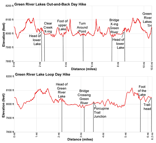
Enter the Bridger Wilderness at 0.7 miles and reach the southeast end of the lake at 2.1 miles. Beyond the lake the path skirts the edge of soggy meadows choked with willow thickets, passing the junction with the Clear Creek Canyon Trail branching left at 2.2 miles. We continue straight ahead on the Highline trail toward Three Forks Park.
At 2.3 miles the path crosses Clear Creek on a bridge and then travels through meadows along the edge of the forest before entering the trees at 2.7 miles. At 3.1 miles the trail reaches a trail junction at a wood bridge spanning the Green River.
Here you need to make a decision. To hike the loop, cross the bridge to the west side of the river and then follow a spur trail across meadows for 0.3 miles to a “T” intersection. At the intersection the Porcupine Trail to Porcupine Pass heads left (southeast). We turn right (north/northwest) on the Lakeside Trail. The trail soon enters a spruce-pine forest and travels along the west side of the lower Green River Lake on easy grades. Overlooks along the lake offer views of the peaks towering above the Clear Creek Valley to the east. Reach the foot of the lake at 5.9 miles and then follow the dirt roads back to the trailhead parking area for a 6.2 mile loop hike.
For the out-and-back hike, continue on the Highline Trail along the east side of the river. Beyond the bridge the Highline swings to the left (east), travels through trees and then lush grasslands above the north end of upper Green River Lake (7,968-ft.). Fine views extend south to Squaretop Mountain and the distinctive Bottle (11,457-ft.), a tower rising to the west of the Squaretop.
At 3.6 miles the path curves to the right (south) and begins a traverse through meadows and spruce-pine forest along the east side of the upper lake. The lake’s beautiful turquoise tint is the result of rock flour, fine grained silt suspended in glacial meltwater that flows into the lake.
Halfway along the lake the trail climbs over a rock outcropping. A few small streams trickle down the slopes above the trail. Near the head (south end) of the upper lake great views open to the limestone cliffs of White Rock towering above the east side of the lake. Reach the head (south) end of the upper lake at 4.75 miles.
Beyond the upper lake the trail skirts the forested fringe along the east side of the valley. The turquoise Green River meanders down emerald green meadows along the valley floor. Squaretop Mountain, flanked by the Bottle to the west, fills the skyline to the south. Travel as far up the valley as time and energy permit. The scenes along this section of the trail are sublime. Pick a scenic spot for lunch and then retrace your steps to the trailhead.
Elevation Profile
Driving Directions
To Green River Lakes Trailhead: From the intersection of Pine Street (US 191) and North Tyler Ave (the Pinedale Tourism office is located on the northeast corner) in Pinedale, WY, drive west on Highway 191 (West Pine Street) for 6 miles and then turn right on WY-352 toward Cora. Follow WY-352 for 25.3 miles to the National Forest boundary, where the pavement ends. Continue straight ahead on Green River Lakes Road (Forest Service Road 600). (Stay along the east side of the river, ignoring any roads branching to the left.)
Follow Green River Lakes Road for 18.5 miles to a signed intersection for the Green River Lakes campground and trailhead. The road to the right leads to the campground. We bear slightly left, staying on the Green River Lakes Road. Continue on the road for 0.2 miles and then turn left at the signed intersection for the trailhead parking area. Drive along the spur road for 0.1 miles to a “Y” intersection and turn right into the trailhead parking area. The road to the left leads to the equestrian parking lot. The trailhead is located at the southwest end of the parking area.
Trail Resources
Trail Intro / Trail Photo Gallery / Trail Map
Basecamp(s) Information:
Green River Lakes
Region Information:
Wyoming's Wind River Range
Other Hiking Regions in:
Wyoming