Details: Blue Lake 
Distance: 6.0 miles (round trip)
Uncompahgre National Forest, near Telluride in Southwest Colorado
By: Diane Greer
Hike Facts
- Distance: 6.0 miles (round trip)
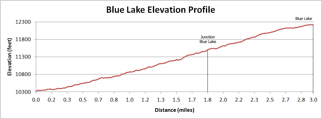
- Elevation: 10,400-ft. - 12,220-ft.
- Elevation Gain: 1,820-ft.
- Difficulty: moderate-strenuous
- Trail Highlights: See Trail Intro
- Basecamp(s): Telluride
- Region: Southwest Colorado

This nice hike up pretty Bridal Veil Basin leads past waterfalls and wildflowers to Blue Lake (12,220-ft.) nestled in a glacial cirque littered with mining relics.
Trailhead to turnoff to Blue Lake
Distance from Trailhead: 3.4 miles (round trip)
Ending/Highest Elevation: 11,472-ft.
Elevation Gain: 1,072-ft.
A hike to Bridal Veil Basin starts with a walk or a drive up the 4WD jeep road that starts just past the Pandora Mill at the east end of Telluride (see driving directions). The road features stunning views of Bridal Veil Falls, Telluride and the restored historic power plant at the top of the falls.
Bridal Veil Falls, the tallest freefalling waterfall in Colorado, plunges 365-ft. from just beneath the power plant to a stream feeding the San Miguel River running through Telluride. An excellent viewpoint at the base of the falls is located 1.2 miles up the jeep road at a hairpin curve on one of the switchbacks. The viewpoint is often enveloped in mist from the water thundering over the rock face and hitting a small pool at the base of the falls.
Beyond the viewpoint it is a 0.8-mile walk or drive up the road to the gate blocking further vehicle access and the start of the hike. This section of the road enjoys wonderful views of the steep cliffs forming the head of the Telluride valley and the town in the distance. Along the way dramatic views open to the power plant perched on a ledge just above the falls. The building, restored in the 1990’s, is listed on the National Register of Historic places.
The power plant, the second oldest AC generation facility in the country, was built in 1907 to supply the Smuggler’s Union Mine. Water driving the generators is piped from Blue Lake, our destination.
If you plan to walk up the road add 4.0-miles to the round trip hiking distances and get an early start. Walking the road turns this into a 10-mile round trip hike to Blue Lake gaining 3,200-ft. in elevation. For more details on walking the road see the Bridal Veil Falls trail description.
The trail into Bridal Veil Basin starts at the gate blocking vehicle access to the power plant. Duck through the gate and stay on the seldom used mining road as it swings to the left (south) and enters the basin. In a few minutes you will pass above the power plant building (on the right). The building and the area around the plant is private property.
Follow the rocky road as it ascends on moderate grades along the left (east) side of the creek, past picturesque cascades and waterfalls. Switchbacks help ease the way up a few steep sections.
During mid-July to early-August the hillsides along the trail are awash in wildflowers. As you climb the trees thin and views open to the north (behind you) to the mountains forming the northern wall of the Telluride valley.
An unmarked intersection is reached after walking 1.7 miles and gaining 1,072-ft. Ahead you will see the top of a distinctive pyramid shaped mountain peeking over the steep hillside. Turn left at the junction to reach Blue Lake. The road continuing straight ahead (the road on the right) leads to upper Bridal Veil basin and the turn off to the Lewis Mill and Lake. (See the Lewis Mill and Lake trail description for more information.)
To Blue Lake
Distance from Trailhead: 6.0 miles (round trip)
Ending/Highest Elevation: 12,220-ft.
Elevation Gain: 1,820-ft.
Beyond the turnoff the trail gets rougher as it ascends a few steep pitches. When you hit a second intersection go right. (Turning left leads to Mud Lake.)
Old tram towers and other evidence of past mining activity is evident along the trail. At 2.6 miles the trail reaches the top of a hill and passes an old wood building with a metal roof.
The grade abates and the trail now climbs gently towards the lake. Several wood mining buildings with metal siding and roofs are seen to the right (west) in the flower-filled meadow below the trail. (Stay on the road. The area around Blue Lake is private property.)
Straight ahead the craggy ridge forming the head of East Basin fills the skyline while to the west you will see La Junta Peak (13,472-ft.) and Wasatch Mountain (13,555-ft.).
Follow the road for another 0.4 miles as it winds through meadows to a rocky overlook above the lake. Blue Lake (12,220-ft.) lies nestled in the rocky East Basin surrounded by peaks towering over 13,000-ft. From this vantage point you can see pipes and other mining debris strewn around the lake.
After taking a break return the way you came, enjoying the wildflowers, waterfalls and views to the north of the peaks rising above the Telluride valley.
Elevation Profile
| Buy the BookThis opinionated guide includes all the hikes in the Ouray, Telluride, Silverton and Lake City sections of the website plus info on local services and nearby attractions. |

Driving Directions
Driving directions from Telluride: Drive east through Telluride on Colorado Avenue for a little over 2.0 miles past the Pandora Mill to a large unmarked parking area. Park here if you are driving a 2WD vehicle. High clearance AWD / 4WD is recommended beyond this point.
If you are in a high clearance AWD / 4WD follow the dirt road, marked as Forest Road #636 on maps, for 2.0-miles up a series of switchbacks to the Bridal Veil Power plant. The road gets rougher and rockier as you climb.
Parking is VERY limited at the top and fills up early in the morning. Be sure not to block the gate. If there is no available parking, turn around and go back down the road until you find a safe, wide spot to park out of the flow of traffic and not on private property. A good place to park is at the base of the waterfall. From the waterfall walk 0.8-miles up the road.
Note: Two-way traffic is permitted between the Pandora Mine and the power plant. The road above the power plant, the notorious Black Bear Road, is one-way downhill toward Telluride. [The Black Bear road, starting south of Red Mountain Pass on Highway 550, goes over Black Bear Pass (12,840-ft.) and descends Ingram Basin on dangerous and difficult switchbacks to meet the 4WD road coming up from Telluride.]
Trail Resources
Trail Intro / Trail Photo Gallery / Trail Map
Basecamp(s) Information:
Telluride
Region Information:
Southwest Colorado
Other Hiking Regions in:
Colorado