Hickman Bridge 
Distance: 1.8 miles
Fruita District, Capitol Reef National Park, near Capitol Reef in South Central Utah
Hickman Bridge
This scenic hike to an impressive natural bridge features fine views of Navajo Dome, Capitol Dome and Pectols Pyramid. Along the way view the foundation of a pit house, spot a granary in a high alcove and discover a small natural bridge, a favorite with kids of all ages.
- Distance: 1.8 miles (RT)
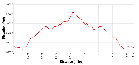
- Elevation: 5,330-ft. at Trailhead
Maximum elevation - 5,730-ft. - Elevation Gain: 400-ft.
- Difficulty: moderate
- Basecamp: Capitol Reef
- Region: South Central Utah
Trail Description - Hickman Bridge
Note: A metal box at the trailhead holds self-guided trail brochures that point out the location of a pit house and granary along the trail as well as describing the area’s geology, plants and animals.
The trail leaves from the northeast end of the Hickman Bridge trailhead. (See driving directions below.) The trail heads east along a low cliff, briefly following the Fremont River as it heads downstream. Soon the path curves left (north/northwest), climbing 120-ft. up moderately-steep switchbacks through a break in the cliff and then grass covered hillsides. Along the way you will pass a marker pointing to a short spur trail leading to ring of black boulders that once formed the foundation for a pit house.
At 0.3 miles reach a trail junction. Bear left at the junction to continue to Hickman Bridge. (Right will take you to the Rim Overlook and Navajo Knobs). The trail now ascends on easy grades through grassy scrub to the top of a small knoll with views of Navajo Dome and Walker Peak to the north and Pectols Pyramid (6,526-ft.) to the south/southeast. Distinctive Capitol Dome rises to the east.
From the top of the knoll the path descends through scattered junipers, pinyon pines and sage to a sandy wash. Here the trail curves to the left (west) and ascends up the left (south) side of a small canyon. Along the way a marker points to a granary used by the Fremont people located in a high alcove on the north (right) side of the trail. Nearby is a rock art panel of red hand prints. A pair of binoculars or the zoom lens of a camera will help you see the granary and pictographs.
Shortly beyond the granary you will see a small natural bridge in the wash off to the right. Kids love climbing around this small formation.
Soon the trail climbs a slickrock slope to the start of the loop section of the hike. Bear right on the loop toward Hickman Bridge, which is now visible.
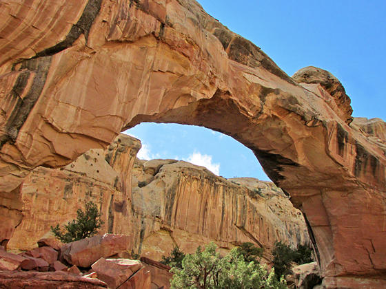
Reach Hickman’s Bridge at 0.9 miles. The impressive 125-ft. tall natural bridge with a span of 133-ft. was carved by water out of the Kayenta formation. The graceful span was named after a local educator, Joseph Hickman, who advocated and worked to preserve Capitol Reef as a National Park. Photographers will have fun using the bridge’s opening to frame the surrounding rock formations.
The trail now passes directly under the bridge and then turns left, walking behind the formation containing the arch to a nice overlook with fine views the Fremont Valley to the southwest. Turn left at the overlook. In a short distance the path rejoins the main trail heading back to the trailhead for a 1.8 mile round-trip hike.
This is a very popular hike, so don’t expect solitude. The trail is best hiked in the Spring and Fall when temperature are cooler. If you go during the summer be sure to take plenty of water and wear a hat.
Elevation Profile
Driving Directions
Capitol Reef Visitor Center: Turn left out of the Visitor Center on Campground Road and after 100-ft. turn right onto UT 24 East. Drive 1.9 miles and turn left into the Hickman Bridge/Rim Overlook/Navajo Knobs trailhead parking lot. The trail starts on the northeast side of the parking area. This is a very small parking lot and can be very busy. There is a fair amount of turnover since most people only hike to Hickman Bridge.
Trail Resources
- Trail Photo Gallery
- Trail Maps
- Basecamp(s) Information: Capitol Reef
- Region Information: South Central Utah
- Other Hiking Regions in: Utah