Escalante River Trail 
Distance: 5.0 - 14.0 miles (round trip)
Grand Staircase-Escalante National Monument, near Escalante in South Central Utah
By: Diane Greer
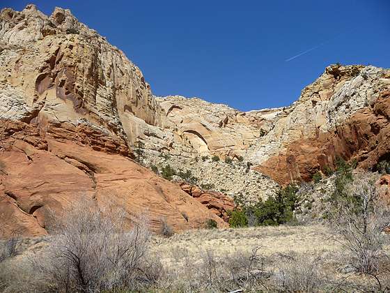
The colors of the canyon walls contrast nicely with the clear blue sky
This beautiful hike, one of my favorites in the Escalante area, travels through a gorgeous canyon beneath towering white Navajo and red Wingate sandstone walls.
See Trail Detail/Full Description
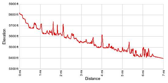
- Distance: 14.0 miles (round trip) to Death Hollow
14.0 miles (one way) to Escalante River Bridge - Elevation: 5,760-ft. at Trailhead
5,390-ft. at Death Hollow
5,190-ft. at Escalante River Bridge - Elevation Gain: -370-ft. to Death Hollow
-570-ft. to Escalante River Bridge - Difficulty: moderate
- More Hikes in:
Escalante / South Central Utah
Why Hike Escalante River Trail
This is one of my favorite hikes in the Grand Staircase-Escalante National Monument. The Escalante River trail traverses a stunning canyon with soaring white Navajo and red Wingate sandstone walls. As you progress down canyon the scenery gets better and better.
The canyon can be explored on a day hike – going as far as you wish and then turning around -- or as a point-to-point backpack. Both options are extremely worthwhile and make for a memorable trip. Backpackers will want to allocate extra time for side trips up Death Hollow and Sand Creek.
Be forewarned that the hike requires frequent river crossing so be prepared to get your feet wet. That being said the walking is generally easy leaving you plenty of time to appreciate the scenic canyon.
Elevation Profile
Trail Resources
Trail Detail/Full Description / Trail Photo Gallery / Trail Map
Basecamp(s) Information:
Escalante
Region Information:
South Central Utah
Other Hiking Regions in:
Utah