Details: Handies Peak 
Distance: 2.3 - 5.4 miles (round trip)
Gunnison BLM, near Lake City in Southwest Colorado
By: Diane Greer
Hike Facts
- Distance: 2.3 - 5.4 miles (round trip)
- Elevation: 11,600-ft. - 14,048-ft.
- Elevation Gain: 1,320-ft. - 2,448-ft.
- Difficulty: strenuous
- Trail Highlights: See Trail Intro
- Basecamp(s): Lake City
- Region: Southwest Colorado
This terrific hike wanders through beautiful American Basin, visits scenic Sloan Lake and then ascends to the summit of Handies Peak (14,048-ft.) with spectacular panoramic views of the San Juan Mountains.
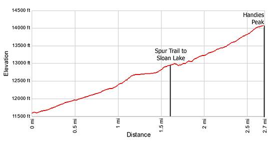
Trailhead to Sloan Lake
Distance from Trailhead: 2.3 miles (round trip)
Ending/Highest Elevation: 12,920-ft.
Elevation Gain: 1,320-ft.
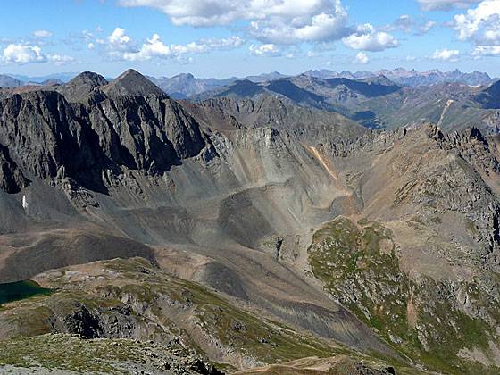
Few trailheads boast the impressive scenery at the start of the hike to Handies Peak. From the parking area views extend south across the basin’s emerald green meadows to the rugged 13,000-ft. ridge towering above the head of the valley. The scenery is especially impressive during late July and early August when a showy display of wildflowers carpets the valley floor.
The Handies Peak trail leaves the southeast end of the trailhead parking area and ascends the hillside on the left (east) side of the valley, heading south into the basin through pretty meadows. At 0.7 miles the path crosses a stream and then continues the moderate ascent toward the head of the basin.
At 1.0 mile the trail splits. The path to Handies Peak turns left (southeast), leaving the valley floor and climbs 325-ft. up a moderately steep hillside. At the top of hill the path descends into a shallow basin, crosses the outlet stream for Sloan Lake and then climbs gently across rocky meadows. Soon the path turns south, climbing steep switchbacks, gaining 200-ft., up to a junction with the trail to Sloan Lake at 1.6 miles. At the junction a short spur trail drops south to the shores of Sloan Lake (12,930-ft.) while the trail to Handies Peak veers left.
The short side trip to Sloan Lake is well worth your time. The aquamarine lake lies cradled in a rugged cirque, anchored to the southeast by American Peak (13,806-ft.). An imposing jagged ridge rises above the lake’s south shoreline.
Sloan Lake to Handies Peak
Distance from Trailhead: 5.4 miles (round trip)
Ending/Highest Elevation: 14,048-ft.
Elevation Gain: 2,448-ft.
To continue hiking to the summit return to the Sloan Lake junction and follow the trail as it curves to the northeast, traversing the talus slopes beneath an unnamed peak on the ridge extending south from Handies Peak. The traverse leads to the southwest facing flank of Handies Peak where a series of steep switchbacks ascend grassy meadows to the 13,490-ft. saddle on the peak’s south ridge, gaining 460-ft. in 0.5 miles.
The way to the summit is now evident. Follow the trail is it steeply ascends the south ridge on scree covered slopes, gaining 560-ft in 0.4 miles.
The panoramic views from the top are some of the best in the area. To the southwest the jagged peaks of the Grenadiers and the Needles Mountains extend to the horizon. To the north are the distinctive summits of the Uncompahgre Wilderness, including Wetterhorn, Matterhorn and Uncompahgre Peaks. To the northeast is the La Garita Range while to the west/northwest the peaks of the San Juan Mountains near Silverton and Ouray, including the Mt. Sneffels Range, fill the skyline.
After taking in the views retrace your steps back to your car. Alternatively, combine the Handies Peak trail with the Grizzly Gulch trail to form a long, strenuous loop. The loop can be hiked in either direction. Many people start at the Grizzly Gulch trailhead and hike up to Handies Peak. From the top follow the Handies Peak trail down through American Basin to the main road and back to the Grizzly Gulch Trailhead. This 10 mile loop gains 3,592-ft.
Elevation Profile
| Buy the BookThis opinionated guide includes all the hikes in the Ouray, Telluride, Silverton and Lake City sections of the website plus info on local services and nearby attractions. |

Driving Directions
Driving Directions from Lake City: Take Highway 149 south for 2.5 miles and turn right (south) on County Road 30 toward the Lake San Cristobal. Follow the paved road approximately 4 miles and then continue on the dirt road for about 16.3 miles. The American Basin road begins at a fork where a sign reads "Cinnamon Pass/American Basin.” American Basin is to the left and Cinnamon Pass is to the right. Turn left and follow the rough 4WD road, with one stream crossing, for 0.9 miles to the trailhead.
Under good conditions, high clearance passenger cars should be able to make it to the American Basin turnoff. Check with the tourism office in Lake City on current road conditions before starting your journey.
Trail Resources
Trail Intro / Trail Photo Gallery / Trail Map
Basecamp(s) Information:
Lake City
Region Information:
Southwest Colorado
Other Hiking Regions in:
Colorado